– Nufenen closed after landslide at pass Severe weather warning for both Basel
A severe storm is expected this weekend. We will keep you updated.
Published today at 11:27
Warning of hail, heavy rain and hurricane-force gusts – a storm will reach Switzerland on Saturday
After the storm in Misox: In the valley, people huddle together – and ask themselves: What’s next?
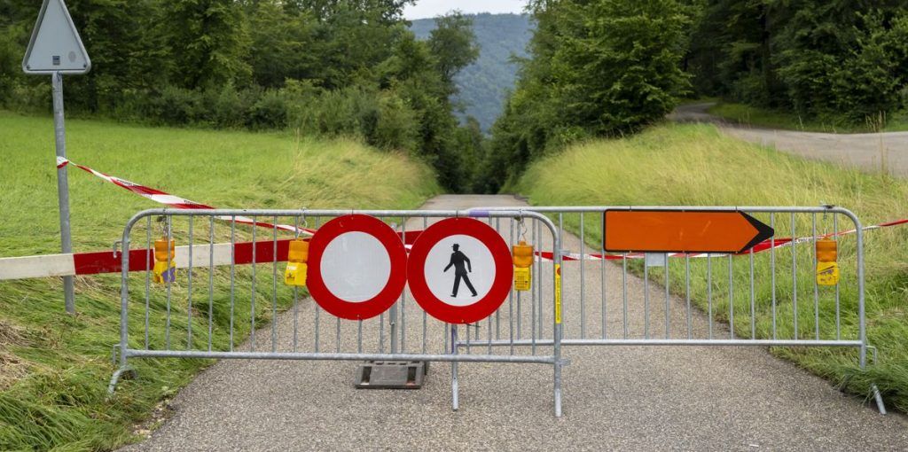
The Nufenen Pass road between Upper Valais and Ticino was interrupted by a landslide on Saturday afternoon. According to the Touring Club of Switzerland (TCS), the incident occurred at the top of the pass.
The closure will continue in both directions until further notice, according to the TCS traffic information. A media spokesperson for the Valais cantonal police said when asked that no cars were affected by the landslide.
According to radar images from meteorological stations such as Meteoschweiz, thunderstorms have been moving across Valais since Saturday morning. The police media spokesperson could not say whether the landslide had anything to do with this precipitation. (SDA)
16:26
The city of Biel and the organizing committee of the Bieler Braderie and the Barbarie jointly issued a storm warning on Saturday afternoon.
According to MeteoSwiss, gusts of wind, thunderstorms, hail and rain are expected in the area.
Visitors to the events are advised to follow the loudspeaker announcements and, if necessary, to seek safety immediately. The operators of market stalls and bars are instructed to secure their infrastructure and prevent loose objects from flying away.
Alertswiss has issued a severe weather warning for the entire region of Biel, Seeland, Bernese Jura and the surrounding area. They recommend, among other things, avoiding open areas and not going into the forest. (law)
3:45 p.m.
Altertswiss has also issued a severe weather warning for the canton of Basel-Stadt. As in other cantons in western and northwestern Switzerland, there is a “high risk of thunderstorms”. The risk is now at level 4. “Hail, rain, strong gusts and lightning strikes must be expected,” according to the federal government’s warning.
The authorities recommend that you do not stay near bodies of water that are flooding. “Flood waves could surprise you and banks could collapse.” You should not go into the forest, avoid open areas, trees, towers, masts and watch out for flying objects. Anyone who is still out in open areas should crouch down if lightning strikes.
Drains and shafts must remain clear so that the water can drain away. In addition, movable objects outdoors should be secured and electrical devices should be unplugged to protect them from overvoltage. (ith)
15:31
The canton of Basel-Landschaft has also published a warning on Alertswiss. The canton is calling on the population not to go into the forest and to avoid open areas, trees and towers. To ensure that rainwater can drain away, drains should be kept clear and movable objects such as garden furniture should be secured against the gusts. Similar warnings were previously issued in the cantons of Aargau, Ticino, Geneva, Vaud, Neuchâtel, Basel-Stadt and Jura. (SDA)
Here you will find additional external content. If you agree that cookies are set by external providers and that personal data is thereby transmitted to external providers, you can allow all cookies and display external content directly.
Allow cookiesMore info
13:16
The canton of Vaud has banned all outdoor events on Saturday afternoon and evening due to the risk of severe weather. It also strongly advises against boat trips on the upper part of Lake Geneva.
In a statement on Saturday afternoon, the Vaud cantonal police stated that meteorologists were predicting an exceptional weather situation on Saturday afternoon. There could be strong winds with speeds of over 100 kilometers per hour, as well as lightning, hail and heavy rain.
According to the communiqué, the decision was made after a meeting of the cantonal management team, which was also attended by meteorologists. The events will be banned until Sunday morning, 8 a.m.
The canton of Vaud also advises avoiding journeys if possible and not going into forests or parks. (SDA)
The canton of Valais is warning of flooding and mudslides in tributaries of the Rhone on Saturday afternoon and overnight into Sunday. The water levels in the Rhone are also expected to continue to rise.
On Saturday afternoon and into the night on Sunday, numerous thunderstorms will cross the Valais. According to the weather forecasts, large, very dynamic thunderstorm cells with “locally violent events” can develop, as the Cantonal Management Body (KFO) announced on Saturday morning.
Precipitation could be very high locally, especially in the side valleys of the left bank of the Rhone. The Entremont, the Val d’Hérens, the Goms, the Binntal and the Simplon region are expected to be particularly affected. However, according to the KFO, other regions could also be affected.
Do not film or take photographs
The melting snow and the waterlogged soil will also lead to a significant rise in the tributaries and the Rhone, which is likely to lead to mudslides and flooding. There is a significant risk of flooding from the mouth of the Saltina to Lake Geneva.
The KFO therefore warns against staying near watercourses. Drivers should not park on bridges, and filming and photographing storms should be avoided in order not to put themselves in danger. The population should generally “restrict their freedom of movement”. (SDA)
11:43 am
A flood warning level 4 is currently in effect for Lake Constance and the Obersee in north-eastern Switzerland. The population is asked to stay away from bodies of water. (SDA)
11:33 am
The canton of Geneva is cancelling all permits for events planned on public land from 2 p.m. on Saturday. The reason for this is a weather warning that a violent storm is expected in the region from late afternoon.
According to Communication from the Geneva Cantonal Administration On Saturday afternoon, there is a high probability of stormy gusts with speeds of up to 100 km/h in Geneva. There may also be large hailstones, lightning strikes and heavy rain showers.
The cancellation particularly affects the fan zone in the Plainpalais area, where 15,000 spectators were expected at 6 p.m. for the start of the European Football Championship match between Switzerland and Italy.
Already on Friday, Meteo Switzerland had warned of an “explosive weather cocktail” that was brewing late on Saturday afternoon, especially in western Switzerland: There was a threat of heavy thunderstorms, which – due to their possible supercell structure – would encourage strong gusts of wind and hail.
The arrival of warm and very humid air in Switzerland with temperatures of up to 21 degrees at around 1,500 meters above sea level, coupled with the daytime warming during the afternoon, will lead to strong instability, according to meteorologists. (SDA)
On Friday, the federal government issued a thunderstorm warning and declared the second highest to highest danger level for Saturday. From the afternoon, severe weather is expected to come from the southwest, some with heavy thunderstorms and hail. The focus is on the Bern region and northwestern Switzerland. In the mountains, strong to stormy southerly winds are to be expected. (van)
Here you will find additional external content. If you agree that cookies are set by external providers and that personal data is thereby transmitted to external providers, you can allow all cookies and display external content directly.
Allow cookiesMore info
The reason for the repeated thunderstorms this summer is that the weather over the Alpine region is practically always dominated by low pressure areas. This is likely to reach a new peak at the weekend. A relatively small low pressure area currently over Spain moved towards the Alpine region on Friday.
A low pressure area over Spain directed thunderstorm-prone air to Central Europe.
Graphics: Fabian Röthlisberger
Just last weekend, storms in Valais and Misox caused devastating damageOn Tuesday it was the turn of western Switzerland and the Basel region. Very slowly moving thunderstorm cells discharged enormous amounts of water, which led to flooding. On Wednesday, thunderstorms on the northern edge of Switzerland caused heavy rain and power outages, and intense thunderstorm cells also formed on Thursday. (mst/van)
A cluster of individual thunderstorms is likely to form over France over the course of Saturday. The German Weather Service (DWD) predicted that the cluster will move eastwards and intensify. The western half of Switzerland, i.e. French-speaking Switzerland, the Bern and Basel regions, is in its path.
Such thunderstorm clusters are quite something. They can “pull out all the relevant accompanying phenomena of thunderstorms to the limit,” says the DWD bulletin. That means: heavy rain, large hail, hurricane-force gusts. (mst/van)
On Saturday, temperatures will be 50 or more, especially in northwestern Switzerland. This means that there will be widespread heavy thunderstorms.
Image: Weather map of the European Meteorological Service ECMWF
Found an error? Report it now.
- -


