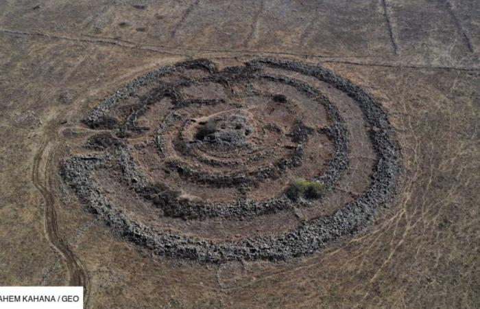
In the middle of the immense plain of the Golan Heights, east of the Sea of Galilee, a region disputed between Israel and Syria, lies one of the most enigmatic structures of the Bronze Age: Rujm el- Hiri, also called the “Wheel of Spirits”. Ceremonial site, burial site, astronomical calendar… Since its discovery in the 1960s, the exact function of the megalithic monument and its several concentric circles of stones surrounding a mound has not been clearly determined.
Just like its counterpart in the south of England – the site is also nicknamed the “Stonehenge of the Levant” – the structure of Rujm el-Hiri has long suggested that it served as an astronomical observatory in its time, around 3500-2500 BC. The results of a new study, published in the journal Remote Sensing on November 14, 2024 and carried out by researchers from the Israeli universities of Tel Aviv and Ben-Gurion, however, seem to definitively rule out this long-standing hypothesis.
Movements and alignment of Rujm el-Hiri
To reach this conclusion, scientists combined geophysical analyses, geomagnetic measurements and advanced remote sensing technologies. They thus discovered that under the Golan Heights, the ground has been subject to tectonic movements – around 8 to 15 millimeters per year – for around 150 million years. After standing for thousands of years, Rujm el-Hiri has therefore undergone a significant reorientation.
By reconstructing the tectonic history of the region, the study authors were able to calculate how the radial walls and entrances of the original structure were aligned when it was believed to have been built, at least 4,500 years ago.
However, they discovered that these elements were not placed in such a way as to allow precise astronomical observations and follow celestial events (solstices, equinoxes). They therefore conclude that from the start, the site was probably not designed for this purpose.
A site at the heart of an old network?
At the same time, the researchers carried out a detailed survey of the surrounding region, mapping an area of 30 kilometers around Rujm el-Hiri. Advanced satellite images have made it possible to identify dozens of previously unknown structures: thick linear walls; circular enclosures approximately 20 meters in diameter; dozens of tumuli, stone mounds which could once have served as burial sites, shelters or warehouses. Such findings suggest that the “Stonehenge of the Levant” may have been part of a larger sociocultural or ritual landscape.
“This research not only challenges previous theories, it also deepens our understanding of ancient life in this region“, its authors enthuse in a press release.
During the Bronze Age, Rujm el-Hiri may have been a huge gathering place for local tribes. Or even a funerary complex, as evidenced by the tombs identified in its central mound. But given the lack of evidence, this remains only speculation.
If this publication rekindles the debate on the function of a unique construction, it also highlights the importance of interdisciplinary research. By combining advanced geophysical analysis techniques and traditional archaeological methods, experts have made crucial advances.
Future studies could explore the connections between Rujm el-Hiri and other ancient structures in the region. And finally, perhaps, to unlock the secrets of this extraordinary monument.


