This Saturday
At 10:30 p.m., the situation is still worrying in the east, from the Meuse to Haute-Marne where the torrential rains continue. Daily rain records for the month of June were also broken. These rains cause the reaction of some watercourses. Flooding is reported in the center of the Meuse department.
© The Weather Channel
At 9:30 p.m, an intense stormy axis stretches from the north of Rhône-Alpes to Lorraine. It demarcates the very warm air which resists in Alsace from the cooler air of Atlantic origin.
At 9:20 p.m., hailstorms sweep across Lorraine and Champagne. These storms are violent, occasionally accompanied by hail.
At 9 p.m., violent storms break out between the north of Rhône-Alpes and Lorraine via Burgundy. More than 50 mm of water fell locally in 1 hour, corresponding to 3 weeks of rain.
À 19 h 50, cIt is between Burgundy, Champagne and the Vosges that stormy and rainy activity is most intense. Be careful if you are traveling between Verdun, Saint-Dizier, Troyes, Auxerre, Dijon and Dole.
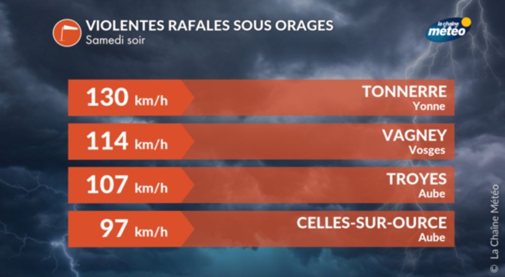
At 7:10 p.m., Storms continue to strengthen in Burgundy and Champagne. A gust of 130 km/h has just been recorded in Tonnerre.
At 6:30 p.m, the situation is deteriorating very quickly. Storm activity is increasing in many regions, from the Cévennes to Auvergne to Limousin and Poitou. It is especially in the east that the storms are expected to be the most violent after the heat accumulated during the day (30°C in Strasbourg and Dijon).
Thunderstorms also form very quickly between the Lyon region, Jura, Burgundy, Berry and the Center-Val de Loire to the south of Paris, towards Essonne and Seine-et-Marne.
At 5:30 p.m., the Midi-Pyrénées region returns to calmer weather after the bad weather. In the Tarn, nearly 100 mm of water fell in Lasfaillades from 2 to 5:30 p.m. On the other hand, the Cévennes and the Massif Central are under heavy and stormy rain. Other storms travel from the Lyon region to the Loire Valley, crossing Berry.
© The Weather Channel
At 5 p.m., While the Tarn returns to calmer weather after the torrential rains of the afternoon, the main rain and thunderstorm activity extends from the north of Languedoc to the south-east of the Massif Central, going up towards Burgundy to Berry and Gâtinais. These storms progress towards the south of Paris, towards Essonne and Seine-et-Marne.
At 4:15 p.m., storms in Occitania are losing strength. These are good stormy rains without any real aggravating character from now on. On the other hand, between Rhône-Alpes and Burgundy as far as Berry, storm activity strengthens very quickly in a heavy and moist air mass.
At 3:30 p.m., most of Occitanie is under storms. It is between Tarn, Aveyron and Lozère that they are the most violent. In Dourgne (81), a storm has just dumped 61 mm of rain in 30 minutes, which corresponds to 3 weeks of rain in the month of June.
These storms move quickly towards Auvergne and Cher. Other storms broke out north of Paris, between the north of Yvelines and the north of Val-d’Oise without any damaging character.
At 2 p.mstorm instability increases. In a very dynamic southerly flow ahead of the cold drop, the air becomes very unstable and storms multiply from Occitanie towards Burgundy via the west of Auvergne. Other storms break out between Sarthe and Normandy. West of Paris, thunder rumbles in the Yvelines.
At 1:30 p.m., the cold drop moves north. It is located on the Massif Central. Behind it, under the rain, the coolness is marked with 15 to 18°C on the Atlantic regions. In front of the depression, the southerly wind makes the temperature rise to almost 30°C east of the Rhône and the Saône.
At 12:45 p.m., A stormy axis stretches from Charentes to Eure-et-Loir. The south of the Paris region is beginning to be affected by brief but heavy showers in Essonne. Another line of storms is moving up from Allier towards Nièvre.
The main storm activity is located in Occitania. Strong storms break out between Carcassonne, Toulouse and Montauban. Other storms come up from Spain and affect the east of the Pyrenees mountain range. Hail is reported in the Cérêt area (66).
At 11:45 a.m., The strongest storms are currently observed between Poitou, Touraine and the south of Sarthe. Other storms, more scattered for the moment, are observed in Midi-Pyrénées. Ahead, the turbulent southerly wind brings heat to the east (between 25 and 28°C) and a dusty tint to the sky linked to the rise of sand from the Sahara.
At 10:30 a.m., Rainstorm activity is weakening in southern Aquitaine while it is increasing in northern Aquitaine, Poitou, Charentes and Vendée as well as in Midi-Pyrénées. Ahead of this deterioration, it is already hot in the east, from Strasbourg to Clermont-Ferrand and Lyon with 25°C.
At 09 hthe stormy deterioration linked to the cold drop which crosses France this Saturday is in place.
It brings heavy rainstorms to Aquitaine. In the Biarritz area, the rains were particularly intense last night, causing some occasional flooding.


