As at the start of each month, we offer you a new climatological report. Now place for the mapped balance sheet of DECEMBER 2024 in terms of temperature, rainfall and sunshine over a panel of 73 stations*. The anomalies presented are calculated from the climatic averages of the reference period 1991-2020 over all the stations in the panel.
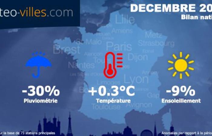
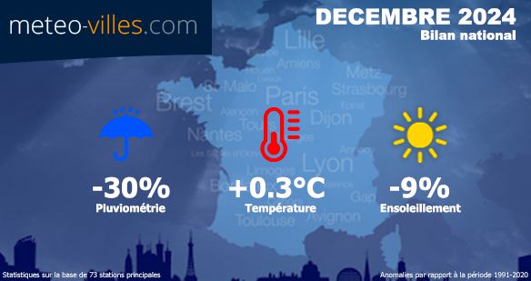
For the month of December, temperatures were very slightly above seasonal averages, with a thermal excess reaching +0.3°C nationally.
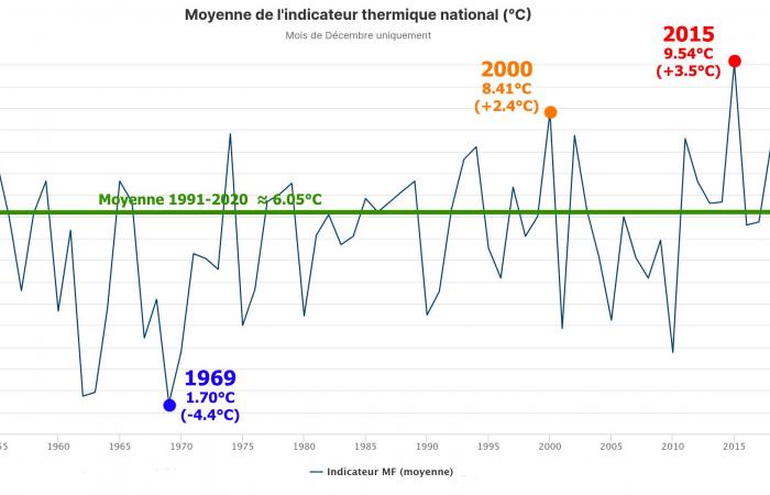
We remain far from the records held by December 2015 (+3.5°C) followed by December 2000 (+2.4°C). However, we really have to go back to 2010 to find any trace of a particularly cold month of December in the country, and only the month of December 2015 was very slightly below the averages over the last 14 years.
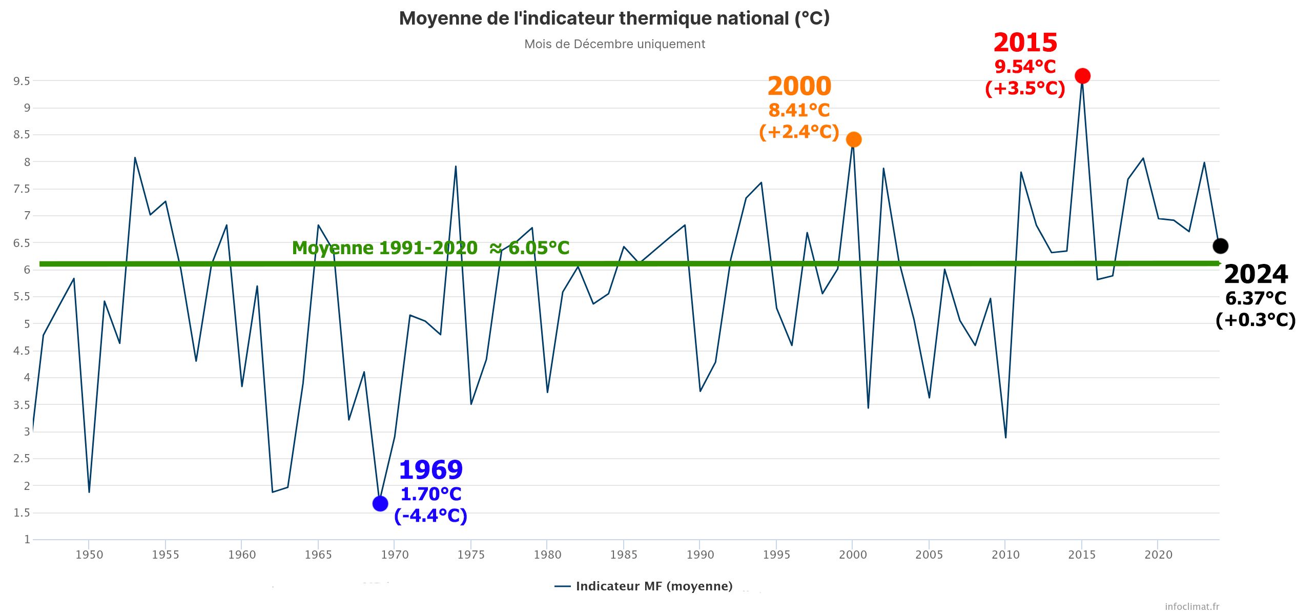
National heat indicator for December 2024 since post-war (1946) – Infoclimat
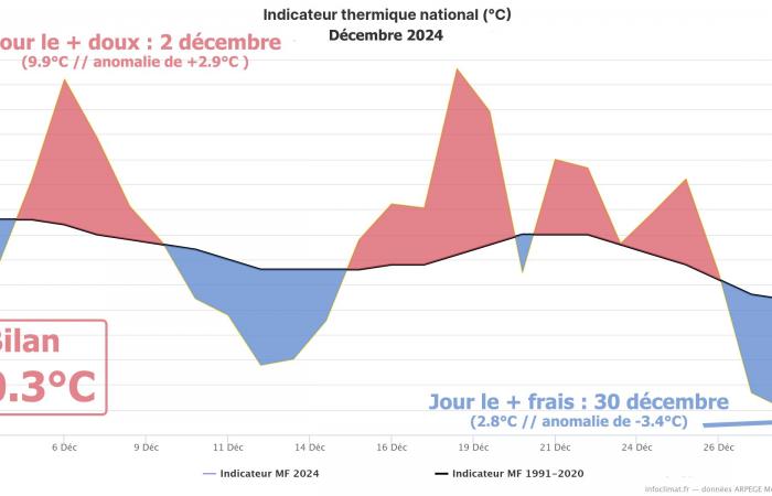
This assessment of +0.3°C does not, however, allow us to highlight certain contrasts according to the periods, which have alternating sweetness and freshness or even coldness. This month of December has indeed started overall in gentleness during most of the first decade. After the passage of storm Darragh, a fresher air took over between December 9 and 14… without being really cold due to the presence of numerous low clouds limiting the formation of frost on the plains (>>).
From December 15 and until the Christmas period, the temperatures are ironed above season averageswith values often above 10°C at the best of the day in the northern half, and sometimes more than 15°C in the southern half. But between Christmas and New Year,The cold has reappeared in the plains under low clouds (certain towns having not experienced a thaw for several days, particularly in the Lyon metropolitan area and the Saône Valley). A striking contrast to the particularly mild air mass which prevailed at the same time at altitude (temperatures above 10°C above 1000m altitude on most massifs).
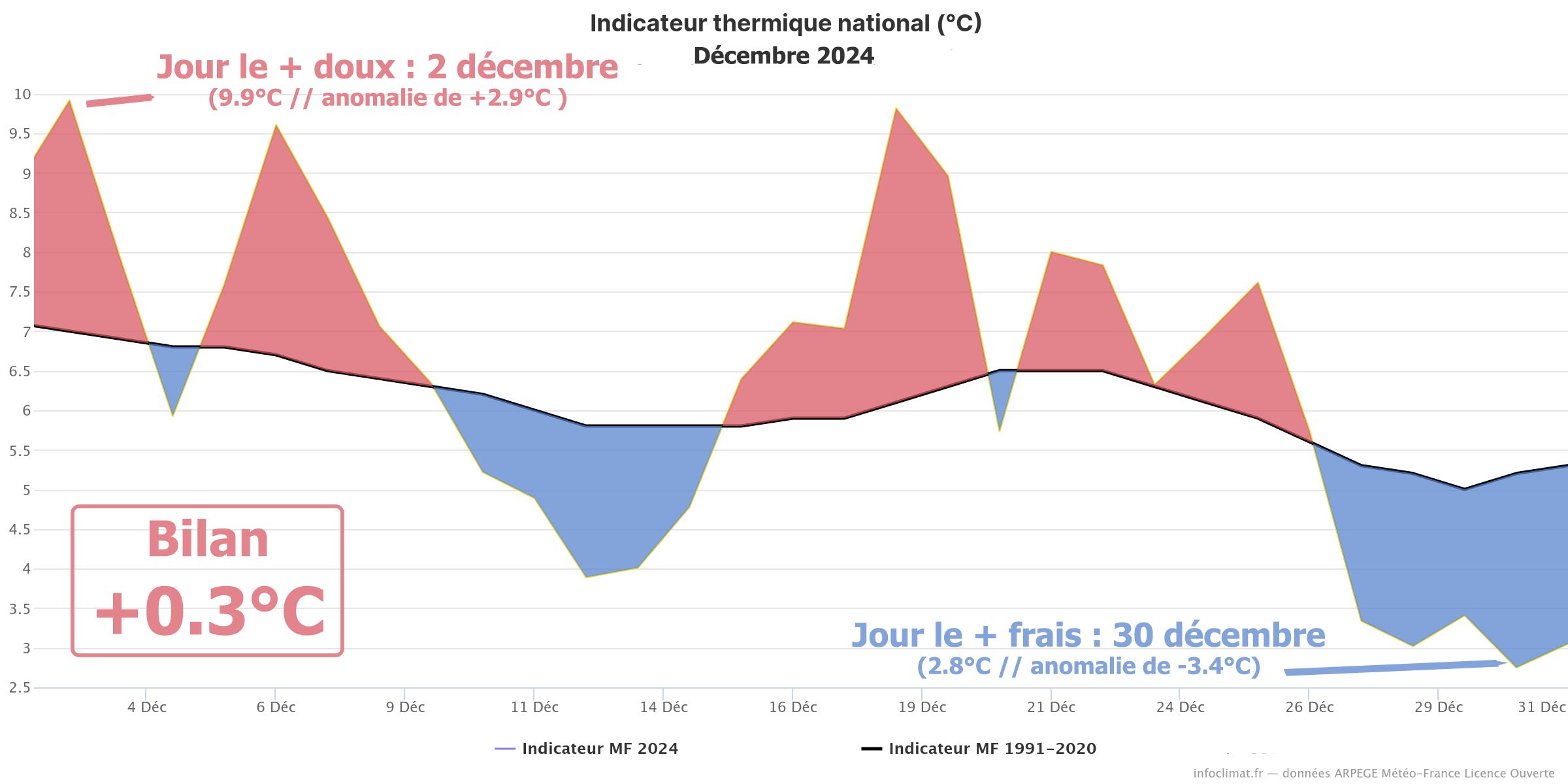
Evolution of daily temperatures in France during December 2024 and deviation from the 1991-2020 average – Infoclimat
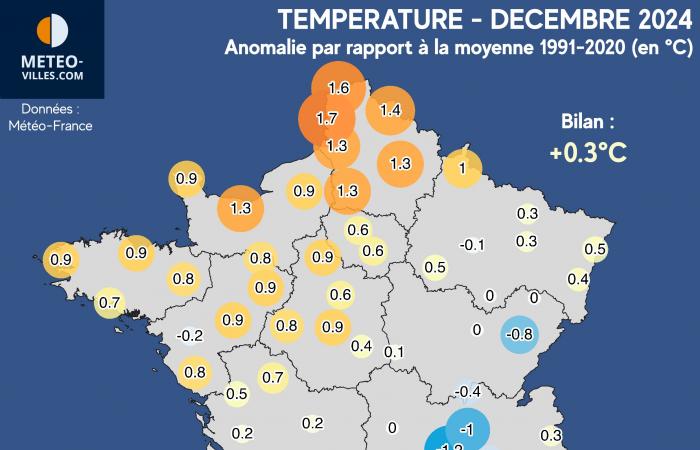
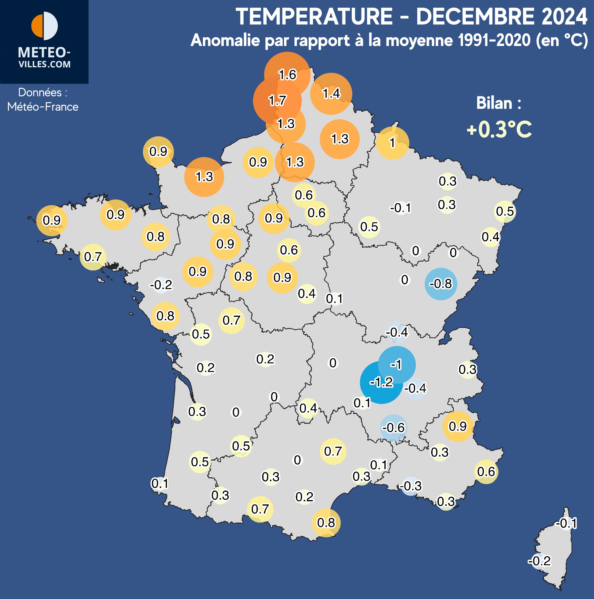
And these contrasts depending on the day are also found depending on the regionwhich were not all in the same boat. First observation: temperatures rather sweet for a month of December for the entire North-West quarter and especially in the Hauts-de-France region where the anomaly is greater than +1°C (+1.3°C in Beauvais or Saint-Quentin, +1.4°C in Lille, +1.6°C in Calais, and up to +1.7°C in Le Touquet). However, the most significant anomalies on the secondary network, greater than +2°C, are at the Breton station of Pommerit-Jaudy (+2.0°C), in the mountains in the Hautes-Alpes Jausiers-Saint-Anne (+2.2°C)and in the Alpes-Maritimes in Valbonne – Sophia-Antipolis (+2.3°C).
Of the Pyrenees to Alsace via Auvergne and New Aquitainethe temperatures were a little more compliant to averages (between 0°C and +0.5°C). The capital and more generally Ile-de-France is more or less in this situation with a surplus of +0.6°C (in Paris and Melun).
To iron below average season, it was necessary to live in this month of December in Corse on the one hand, but especially in an area going from Doubs in the Saône Valley and the Rhône Valleywhere the low clouds and fogs were omnipresent and tenacious, blocking cold air on the ground: the anomalies went down to -0.8°C in Besançon, -1.0°C in Lyon or even -1.2°C in Saint-Etienne. On the secondary network, the most marked deficits are found in these aforementioned regions, with -1.6°C in Pontarlier (Doubs) or -1.6°C in Figari (Southern Corsica), and up to –1.7°C in Valdrôme (Drôme).

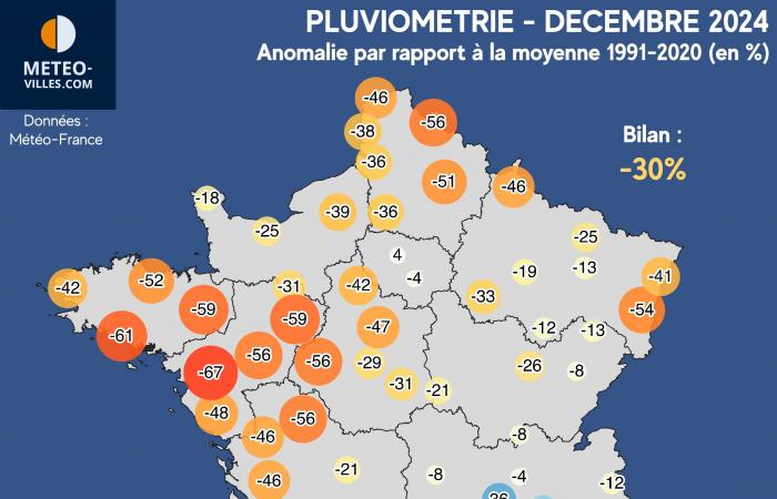
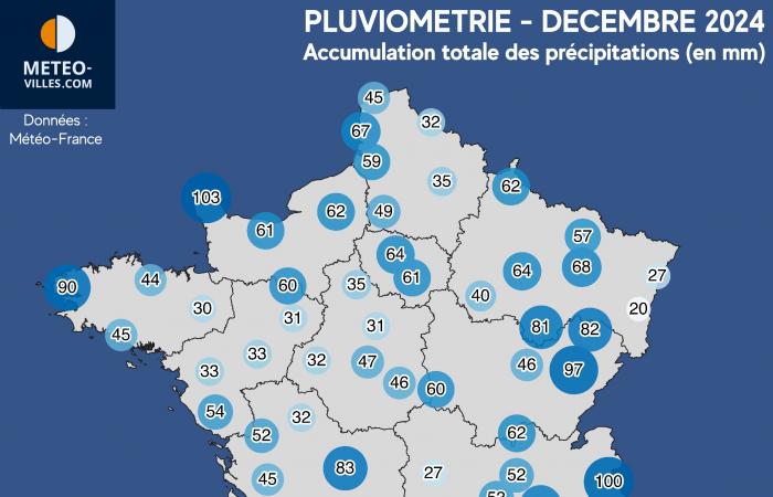
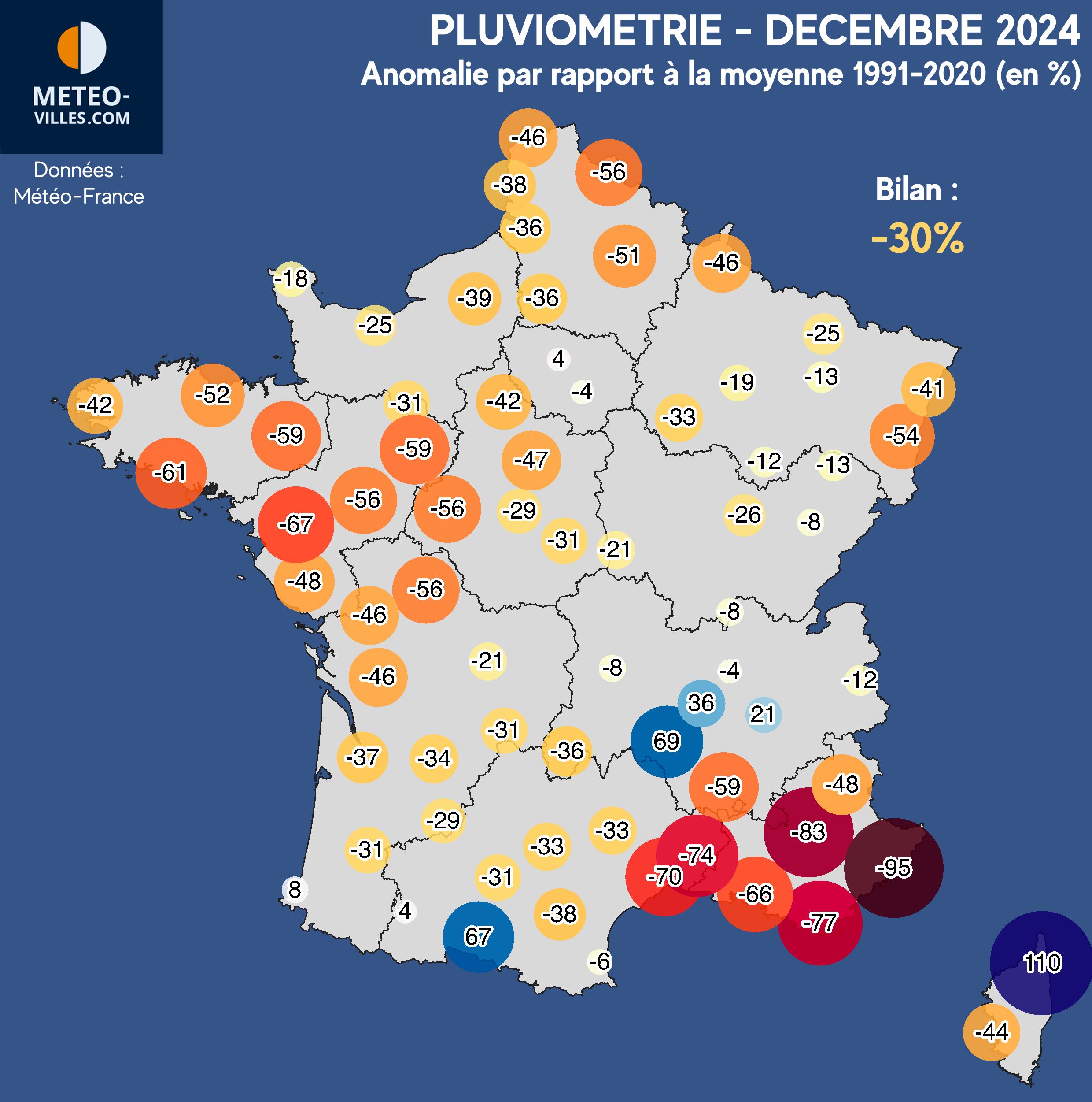
In terms of rainfall, this month of December markedly contrasted with the particularly humid previous months. In fact, the rainfall balance on our panel of stations is deficit of around -30% for December 2024.
The reason is simple: the frequent presence of high pressures over the country, stopping the recurrence of recent months (flow of oceanic origin). The rains were therefore scant, concentrating mainly during the passage of storm Darragh around December 7 (stormy winds over the entire Atlantic coast, the Channel coasts, Roussillon and Corsica, and return of snow in the mountains >>), during the end of the second decade, or even between December 22 and 24 with heavy snow across all mountain ranges (>>).
The end-of-year holiday week between Christmas and New Year then took place without precipitation under the anticyclone, and far too often under low clouds and fog (>>).
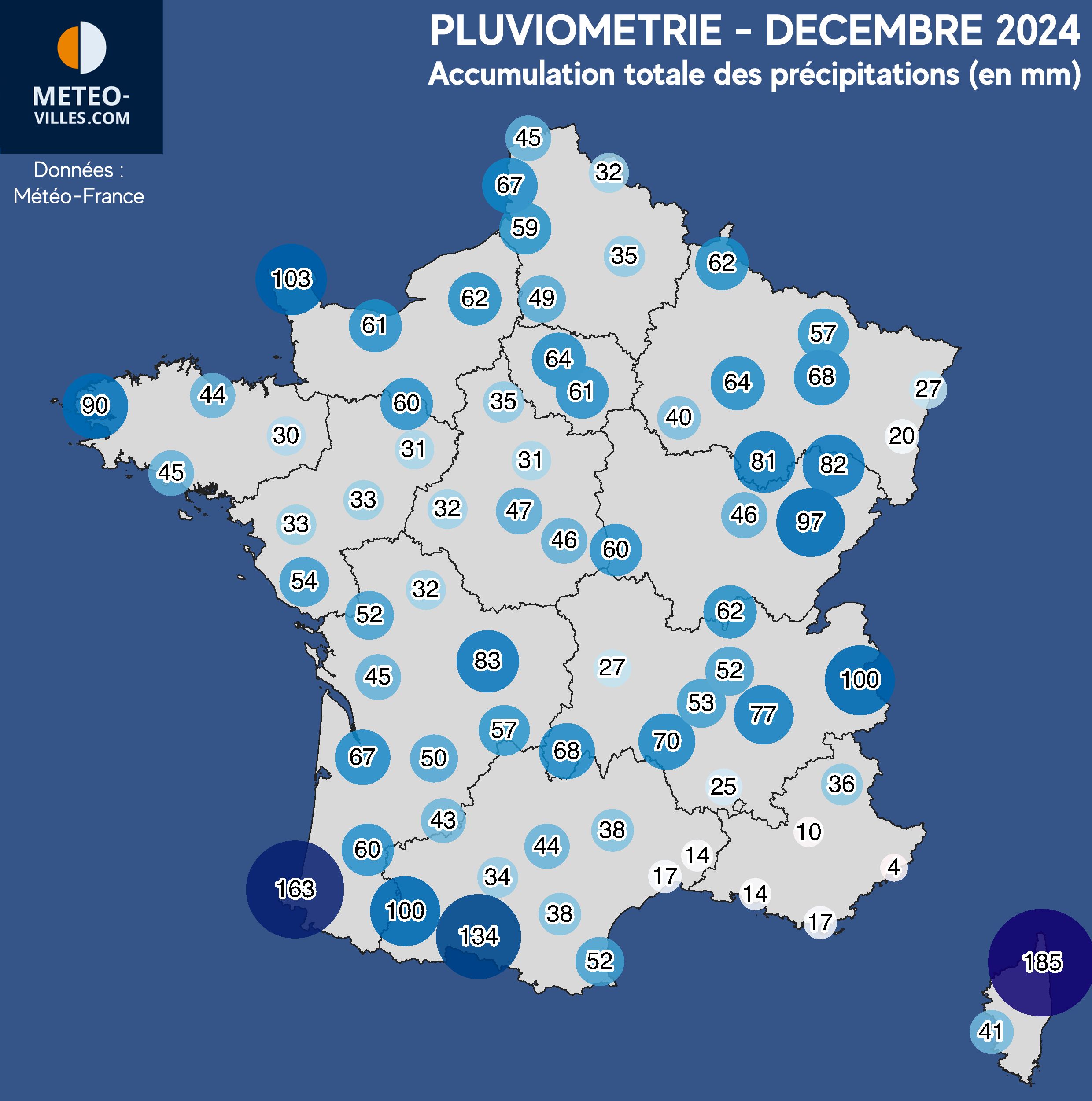
Few areas have exceeded their monthly rainfall norm. They mainly focus on the Pyrenees chain (up to +67% in Saint-Girons, and even +138% in Caixas near the Pyrenees-Catalans), on theEast and South of Auvergne (+36% in Saint-Etienne, +69% in Puy-en-Velay), or even on the Upper Corsica (+110% in Bastia and even +171% on the secondary network in Oletta). Paris is also an exception with a very slight surplus of around +4%.
Everywhere else, the deficit appears significant, between -10 and -30% in the North-East or even up to -50% in Alsace (-54% in Colmar), -20 to -40% on the South-West plains (-31% in Toulouse, -37% in Bordeaux), or even -40 to -60% in the North-West (-56% in Châteauroux and Lille, -59% in Rennes and Laval, -61% in Lorient, -67% in Nantes).
The precipitation was even very low on the Languedoc and all of Provence with -70 to -90% (-74% in Nîmes, -77% in Hyères, -83% in Saint-Auban, and even -95% in Nice). This is indeed the Côte d'Azur and the Alpes-Maritimes department who have deficits close to 100% over this month (-98% in Ascros, -97% in Péone and Mandelieu, -96% in Cannes).
In all these deficit regions, the cumulative rainfall only exceeds rarely 50mm during this month of December. In the Northwestwe are even around 30mm only in eastern Brittany, in Loire" rel="tag">Pays de la Loire, Center-Val-de-Loire (30mm in Rennes, 31mm in Orléans, 33mm in Nantes). Even lower precipitation on the coast of Limagne (27mm in Clermont-Ferrand) and on the Alsatian plain (27mm in Strasbourg, 20mm in Colmar).
On the Languedoc and Provencethe rains were fairly anecdotal, around 10 to 15mm on average (14mm in Nîmes and Marseille-Marignane, 17mm in Montpellier) or even almost zero in the Alpes-Maritimes (4.4mm in Nice, 3.2mm in Mandelieu, 2.0mm in Ascros).
On the side of cities and surplus regionsthe accumulations on our panel only very locally manage to reach 100mm (up to 100mm in Bourg-Saint-Maurice, 103mm in Cherbourg, 134mm in Saint-Girons, 163mm in Biarritz and 185mm in Bastia). The highest values on the secondary network are to be put for the stations of the Pyrénées-Atlantiques and Haute-Corse with in places more than 250mm : 290mm to Scata (2B) et 295mm for the Banca (64) and Laruns (64) stations.

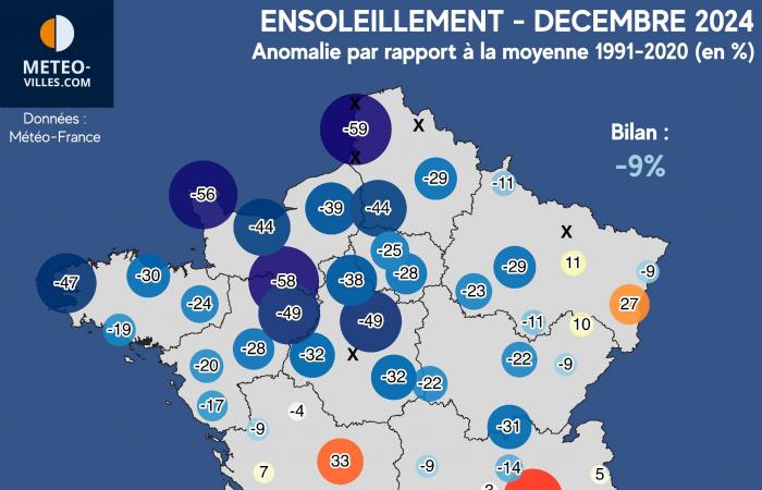
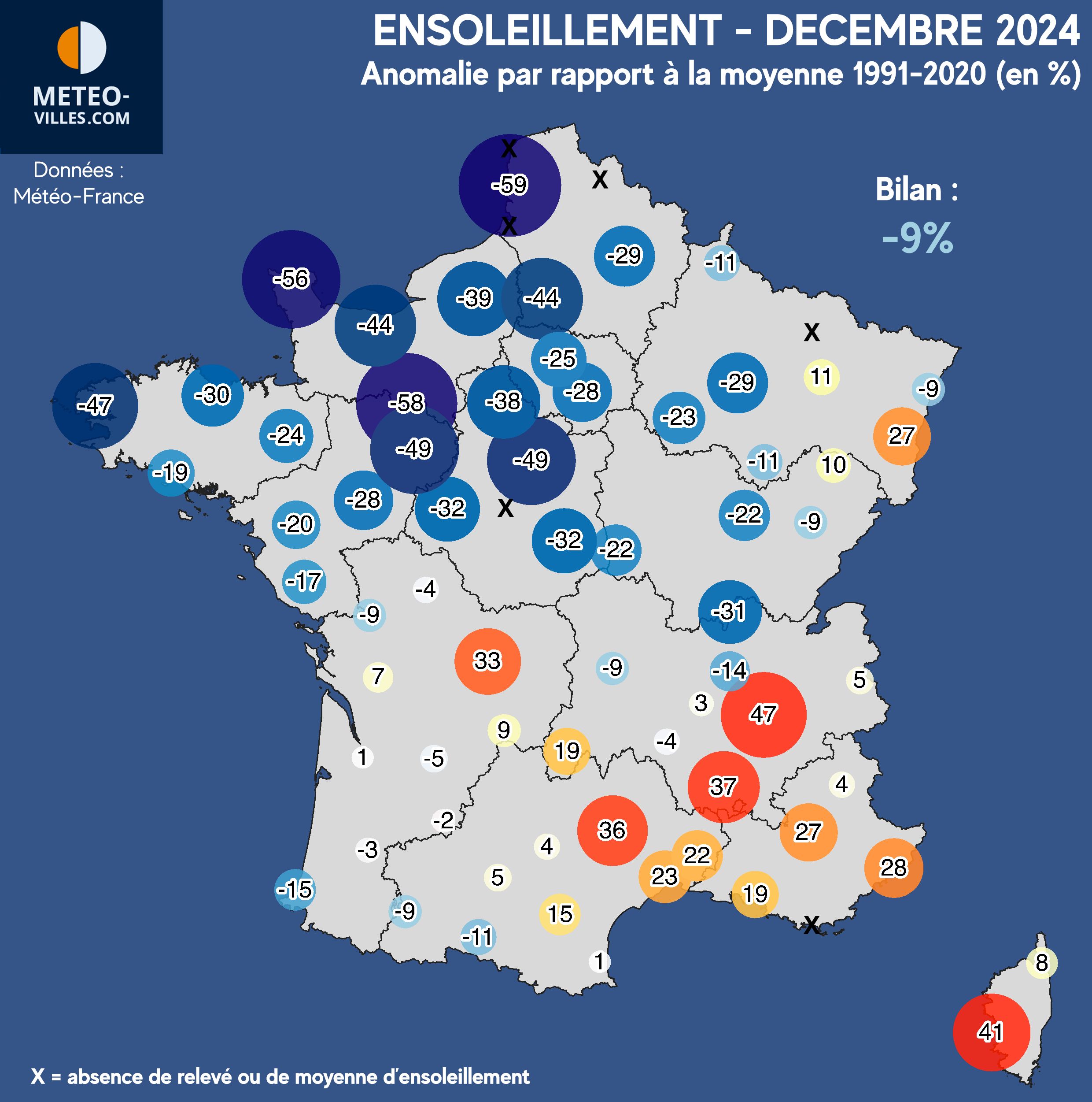
Let's end this monthly assessment on the side of sunshine, which, although contrasting, is hardly encouraging with a deficit on our national panel having reached -9% this month of December 2024.
This month was indeed marked by several anticyclonic sequencesespecially during the week between Christmas and New Year when more than 2/3 of the country was under lockdown. grayness and fog (>>). Outside of these periods, the rare more low-pressure spells (such as the Darragh storm at the end of the first decade) obviously did not bring more sunshine to our regions (>>).
With such a global synoptic, the sunshine rates were particularly low over almost the entire northern half of France under these low clouds. On the North-West quarterthis deficit is remarkable, reaching on average -25 to -50% in most cities, or even less: up to -56% in Cherbourg, -58% in Alençon and -59% in Le Touquet station. Paris comes out with a balance sheet also clearly in deficit of -25%.
The stations at foot of the Pyreneesor even some valleys (Saône Valley, Rhône Valley, Limagne) also experienced a very gray and gloomy month: -31% in Macon, 15% in Biarritz, -14% in Lyon, -9% in Clermont-Ferrand…
Despite this sad record, the South-East quarter was, on the contrary, able to benefit from much sunnier conditions with +20 to 40%the low clouds not having reached these sectors during the month (+23% in Montpellier, +28% in Nice, +37% in Montélimar, +41% in Ajaccio). Often above these low clouds, the mountain towns, the pre-Alps or even Limousin were also able to enjoy generous sunshine: up to +33% in Limoges, +36% in Millau and even +47% in Grenoble-Saint-Geoirs. The Haut-Rhin is also doing quite well, with +27% in Colmar (unlike its neighboring city of Strasbourg and its -9%).
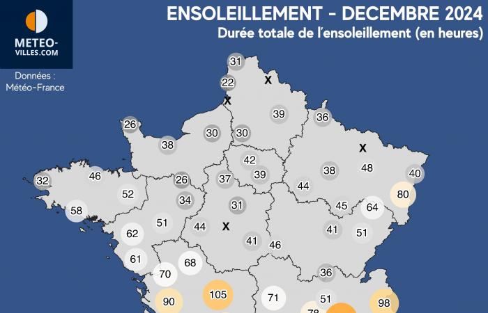
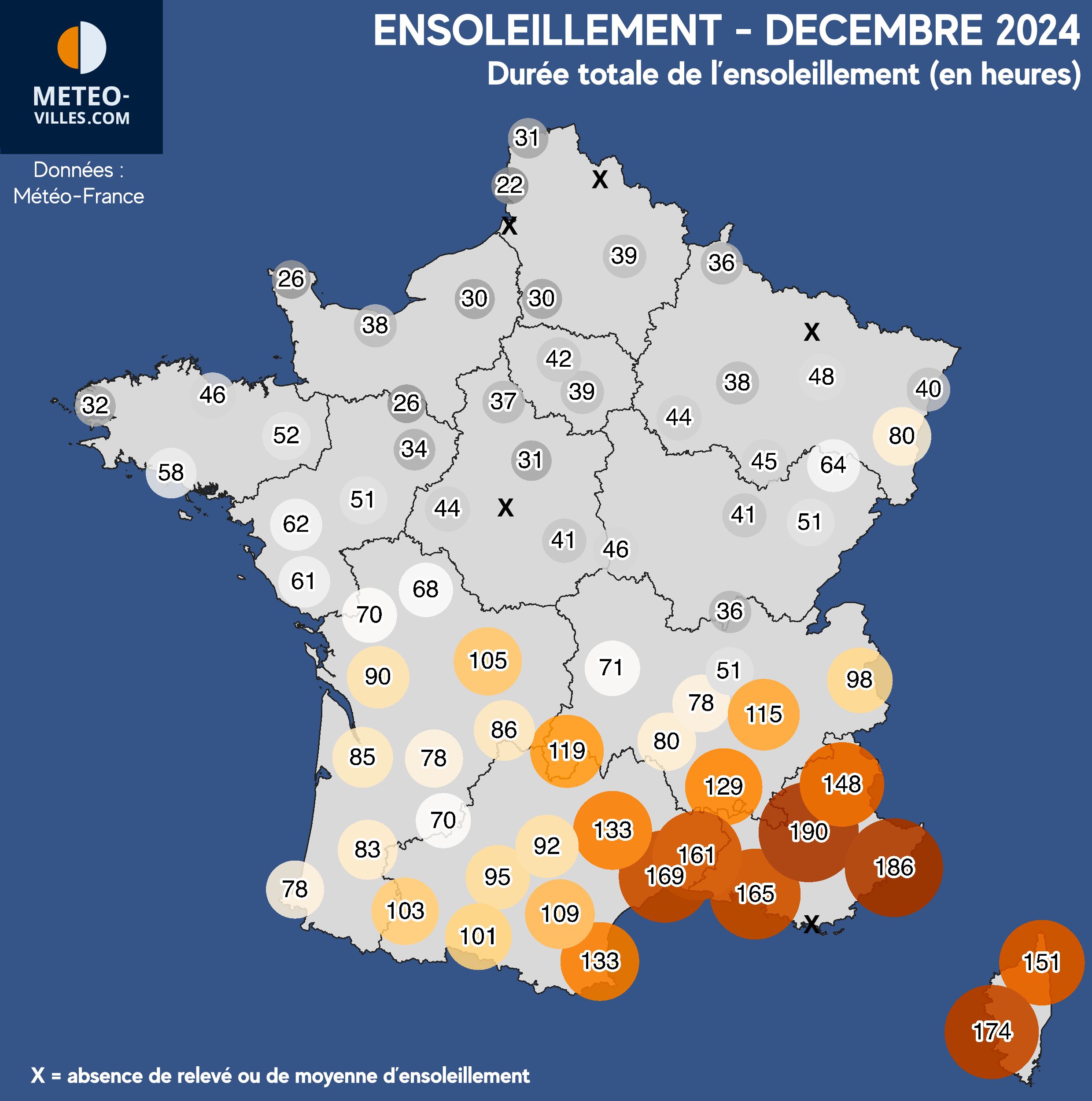
Such a deficit over the entire northern half results in overall sunshine durations less than 50 hours for this month of December north of the Loire (i.e. less than 2 hours of sunlight per day on average). Some cities are even less well off with 30 hours or less: only 30 hours in Rouen and Beauvais, 26 hours in Cherbourg and Alençon, and a poor record of 22 hours at Le Touquet (national minimum). As for Paristhe capital station is closing this month with 42 hours.
In the quarter Southwestthe sunshine values oscillate on average 80 to 100 hours, or even slightly beyond (103 hours in Tarbes, 105 hours in Limoges, 119 hours in Aurillac). But it is indeed in the South-East and near the Mediterraneanas so often, where this sun has been the most generous with often more than 150 hours of sunshine : up to 169 hours in Montpellier, 174 hours in Ajaccio, 186 hours in Nice and a maximum of 190h in Saint-Auban. On the secondary network, the Péone station (Alpes-Maritimes) climbs to 194 hours.
Summary:
* PANEL OF 73 STATIONS
Temperature – rainfall – sunshine:
Agen, Ajaccio, Albi, Alençon, Angers, Aurillac, Bastia, Beauvais, Bergerac, Besançon, Biarritz, Bordeaux, Bourges, Bourg-Saint-Maurice, Brest, Brive, Caen, Calais, Carcassonne, Charleville-Mézières, Chartres, Château- Arnoux-Saint-Auban, Châteauroux, Clermont-Ferrand, Cognac, Colmar, Dijon, Embrun, La-Roche-sur-Yon, Langres, Le Mans, Le-Puy-en-Velay, Le Touquet, Limoges, Lorient, Luxeuil, Lyon-Bron, Mâcon, Marseille-Marignane, Melun, Millau, Mont-de- Marsan, Montélimar, Montpellier, Nancy-Essey, Nantes, Nevers, Nice, Nîmes-Courbessac, Niort, Orléans, Paris-Montsouris, Perpignan, Poitiers, Rennes, Saint-Brieuc, Saint-Etienne, Saint-Dizier, Saint-Geoirs (Grenoble), Saint-Girons, Saint-Quentin, Strasbourg, Tarbes, Toulouse-Blagnac, Tours, Troyes.
Temperature – rainfall (absence of sunshine data):
Abbeville, Hyères, Lille, Metz, Romorantin.


