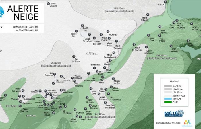
We're starting the new year strong! As anticipated in the winter forecast published in mid-November, everything now indicates that the heart of the meteorological winter, i.e. the period from January to mid-February, will actually be marked by normal or slightly below temperatures. these as well as above-normal precipitation. In other words, it’s like pressing the “reset” button on winter and it starts on New Year’s Eve…
Indeed, after a few centimeters fell locally in the mountains in the last hours, a disturbance coming from the central United States will move up towards the south of the Great Lakes during the day of the 31st, then give rise to a new depression near New York on Wednesday. January 1st. This depression will intensify rapidly as it slowly continues its course towards the northeast towards the mouth of the river. This system will bring abundant amounts of snow to places in Quebec as well as strong winds that could cause blowing snow where the mercury remains below zero…
Please note that heavy snow or winter storm warnings could be issued by Environment Canada if the situation requires it. When the precipitation arrives, the mercury will still be above freezing, so we will have a small period of mixed precipitation before switching to flakes. One thing is certain, travel for New Year's Day is likely to be difficult and cold weather conducive to snowfall will definitely settle in at the back of the system, starting Thursday and Friday.
Even if the stations of the Laurentians will receive around ten centimeters, the regions most spoiled by snow will be part of the Laurentians, Lanaudière, Mauricie and Charlevoix for the north of the St. Lawrence, and in the south, the accumulations will be especially marked at altitude, notably in the Eastern Townships up to Chaudière-Appalaches. These regions could win the jackpot with accumulations exceeding 25cm locally. However, the washout experienced at the beginning of the week will be difficult to forget… The system will continue its path eastward until Thursday; An update of the map above is planned for January 1st.
We invite you to follow the evolution of the situation by regularly consulting the updates made by your favorite stations over the coming hours. There is still uncertainty regarding the exact trajectory and intensity of this system, such that we could receive more or less precipitation than anticipated.
Zone.Ski and Météo Laurentides take no responsibility for any consequences that could result from an incorrect forecast.


