End of year 2024 calm but meteorologists are carefully monitoring the evolution of the forecasts for the first half of January 2025. There is a risk of a more marked cold snap over Europe, or of a cold wave, even if uncertainties still remain significant. We explain everything to you below.
1) Evolution of the atmospheric context between the end of 2024 and the beginning of 2025:
As we have been indicating for several days in our articles, France remains at the end of December under the influence of an anticyclone which stretches from the Azores to our country via the Iberian Peninsula. It protects us from disturbances and also promotes marked thermal inversions since it is cold at night and very mild during the day. We are certainly heading towards a redistribution of 'weather maps' at the beginning of January. As always, this will be done in several stages.
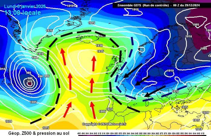
At the beginning of January, we see the anticyclonic cell strengthening near the Azores. At the same time, the ocean current (the westerly winds) will definitely slow down. For the moment, we will not speak of a reversal of the zonal winds, but the loss of dynamism of the westerly flow will have the consequence of favoring the rise of the anticyclone towards Greenland and Iceland. Around January 3, we could then have two large atmospheric groups in our hemisphere: the formation of an anticyclonic block in the West and the start of a polar shift in northern Europe:
2) How to understand the rest of the program?
The future configuration is in itself classic and presents the usual uncertainties. The rise of high pressure towards high latitudes between Greenland and Iceland is generally a marker of the establishment of a northerly flow over Europe. France is then concerned, but the “winter pattern” remains very modest with snow at very low altitude only in the north and the reliefs, while the cold is much more modest in the south and the weather is dry (mistral & tramontane around the Mediterranean).
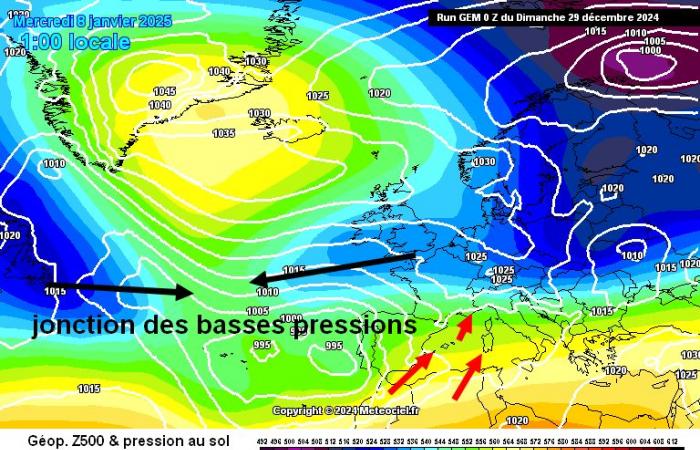
Everything will depend on the future of the depressions coming from Labrador and Newfoundland (see on the map below). In the triggering phase of the “cold waves” there is always this timing where the models see the depressions coming from Newfoundland making a junction with the European low pressures, then cutting off the supply of the anticyclone over the Atlantic and aborting any attempt at a cold snap. Perfect illustration with the GEM model today (see map below). In this case, it is mild in the south and cool in the north of France. The cold air remains on the fringes of our country in general (Germany / Poland) even if temporarily a conflict of air masses approaches.
3) Sometimes, the low pressure junction does not occur and this develops into an Icelandic blockage:
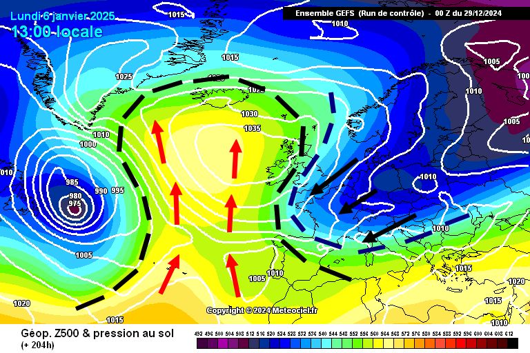
This will be the scenario to watch because it is generally relayed by short-term seasonal models. In this case, the low pressure junction between the low pressures coming from Newfoundland and Europe does not occur and the anticyclonic block continues to strengthen over the Atlantic. Little by little, high pressures migrate towards Iceland. We are then in a configuration where the polar shift is becoming widespread in Europe, including France, with a flow which is oriented more towards the North-East.
In this scenario, not only do we have frankly wintery temperatures EVERYWHERE but on top of that there is a risk of depressions over the Mediterranean and therefore of a snowy episode at very low altitude. Below, we find the illustration of this scenario with the GEFS model.
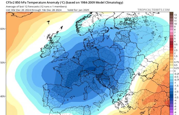
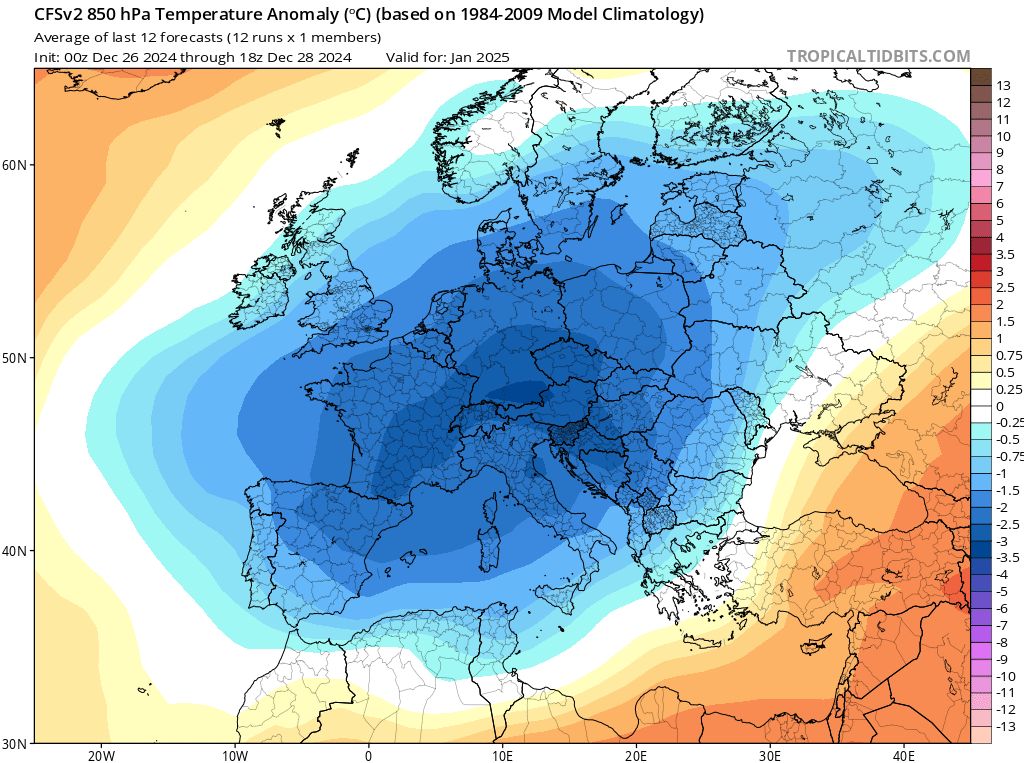
CONCLUSIONS : It is still too early to say that a cold wave will affect Europe and France during the first decade of January. However, the situation is under surveillance because the signal tends to strengthen, supported by seasonal modeling which sees temperatures below seasonal norms for 15 days. It is important to remember that in the past it has happened that seasonal models have gone completely wrong, particularly here in France because we are often at the crossroads of influences.
We believe a moderately wintry pattern is becoming likely. The “snowy cold wave” option is still in the minority, but that is normal at such deadlines. The CFS seasonal model below, in its monthly version, speaks for itself:
Facebook
Twitter
Google+


