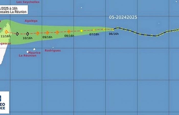
A disturbed area (No. 5) has been identified to the east of the Mascarenes. This convective activity is located 2,910 km from Reunion, at points 14° 1 South and 82° 4 East. It could become a moderate tropical storm on Wednesday. The cloud cluster is moving towards the West at 22 km/h. It does not present any danger for the next 72 hours.
The cyclone activity bulletin published by Météo-France La Réunion, Monday January 6, 2025 at 4:48 p.m., draws our attention to the presence to the east of the Mascarenes of a disturbed zone (n°5 of the 2024/2025 season) . This remarkable activity is located 2,910 km from Reunion and moves westward at 55 km/h.
It was located, finally on Monday afternoon, by points 14° 1 South and 82° 4 East. Maximum winds, estimated at sea, were 35 km/h and maximum gusts, estimated, 55 km/h.
However, it is possible that this phenomenon will develop into a moderate tropical storm this Wednesday, January 8, 2025.
According to meteorologists' first estimates, the system should continue its route towards the West, hitting Saint-Brandon, then Tromelin before landing in the north of Madagascar.
“The extent and location of the degradation remain to be clarified.write the forecasters.
- Moderate tropical storm,
- Center positioned on 8/01 at 14° 8 South and 68° 5 East.
- Moderate tropical storm,
- Center positioned on 9/01 at 15° 2 South and 61° 7 East.
- Severe tropical storm,
- Center positioned on 10/01 at 15° 5 South and 55° 5 East.
- Moderate tropical storm,
- Center positioned on 11/01 at 14° 9 South and 48° 8 East
“Attention : The previous trajectory and intensity forecasts should be considered with the greatest caution given their uncertainty. They only concern the position of the center of the phenomenon, without consideration of its extension.
France


