As the world’s oceans have moved into their 12th consecutive month as the warmest on record, a new NASA Earth-observing satellite mission has come online to monitor the health of the oceans and the particles in the atmosphere.
The PACE satellite (Plankton, Aerosols, Clouds, ocean Ecosystem) launched from Florida’s Kennedy Space Center on Feb. 8 and has begun to send data and images back to the ground.
The data will help atmosphere, ocean and Earth scientists get a more precise look at microscopic life in the oceans and small particle matter in the air. In turn, this will enhance our understanding of these impacts on fisheries, contributions to harmful algal blooms and detection of small air pollution particles.
People are also reading…
New on the PACE satellite is its Ocean Color Instrument, built and managed at NASA Goddard Space Flight Center in Maryland. In addition to picking up more precise differences in color in the ocean below, it also examines both the atmosphere and surface in ultraviolet and infrared light — using detectors in more than 200 separate wavelengths of light.
This higher precision allows the scientific community to identify specific areas of phytoplankton in oceans and large lakes. These tiny oceanic plants take in carbon dioxide and produce oxygen through photosynthesis. While microscopic in individual size, the number is colossal — enough to produce about half of the oxygen in our atmosphere.
Also known as microalgae, some of these phytoplankton can grow rapidly and uncontrollably, causing health problems for humans and animals. Early detection of the difference between the two is important in understanding and managing our oceans and lakes.
Infamously, red tides are one example of these harmful algal blooms and are responsible for contaminating shellfish, closing beaches and killing fish. The satellite gives us an extra set of eyes in the sky to help identify where these blooms occur, when they are most likely, and how long they will last. The data from the satellite will enable us to make better decisions to minimize these blooms in the future.
Two other instruments on the satellite will measure the polarized light that bounces off of clouds and impurities in the atmosphere — called aerosols. These particles, like sea spray and elements of wildfire smoke, are so small that they remain suspended in the atmosphere. This improved detection will enable better air quality forecasts and increase our understanding of how these particles influence the formation and evolution of clouds, which are important for improving weather forecasts and strengthening our understanding of the climate system.
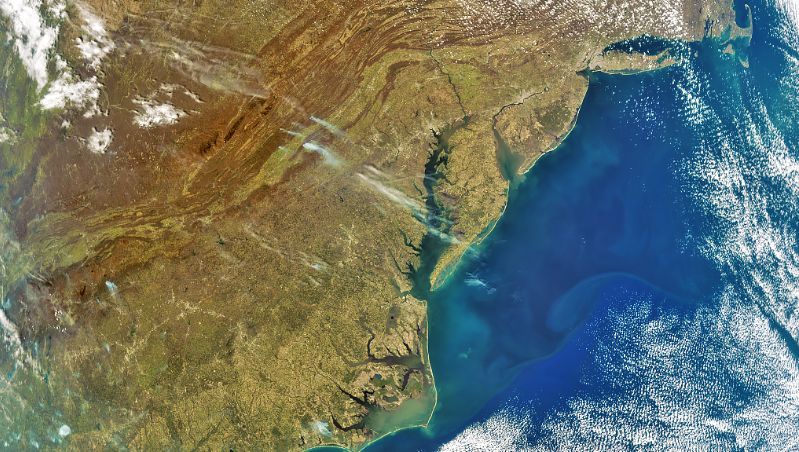
NASA PACE Image, March 2024. Wildfire smoke plumes are visible in the central Appalachians.
Unlike most weather satellites, which monitor conditions over one specific location, PACE is in a much lower orbit around Earth, racing from pole to pole as Earth rotates beneath it. As a result, it has complete coverage of surface conditions on Earth after about two days of orbits.
The mission has a minimum design life of three years, but has more than 10 years of propellant, so it is likely to provide data well into the 2030s.
Local Weather
Get the daily forecast and severe weather alerts in your inbox!


