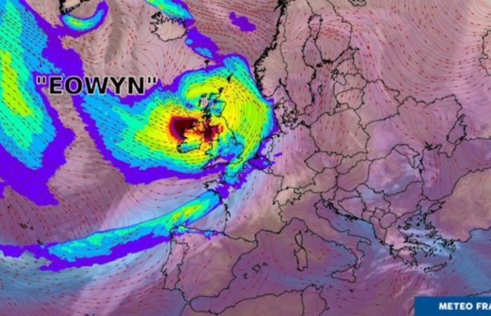
Storm Éowyn is described as a “weather bomb”. For what ? Where does she come from? What will be its consequences?
Winds of 130 hm/h to 150 km/h on the British coasts and reliefs: storm Éowyn will violently hit Ireland, England and Scotland from this evening, on the night of Thursday 23 to Friday January 24, 2025, then all weekend. What consequences in France and the United Kingdom?
Storm Éowyn in France
Storm Éowyn will not have as powerful an effect in the metropolis. Météo-France announces gusts of 80 to 90 km/h on the North-West coasts on Friday, which is relatively high, but far removed from the British winds at the same time. There are no notable alerts at this time.
The temperature in France should even cool down in the coming days with values higher than those we experienced last week. Rainy episodes are to be expected.
The risk in the United Kingdom
This storm, however, is indeed worrying the British authorities. In Ireland, the weather service issued a red alert for winds, warning of gusts ” severe » et « destructive ”, risking causing damage. In England, the Met Office – government meteorological office – warns that there could be “ a danger to life » because of flying debris carried away by strong winds.
Why a “weather bomb”?
Storm Éowyn is described as a “weather bomb”. This is a term that describes a very specific situation. “ Certain depressions have the particularity of deepening very quickly and very strongly (typically more than 24 hPa in less than 24 hours), we then speak of explosive cyclogenesis. », Explains Météo-France. However, storm Eowyn will see its pressure increase from 970 hectopascals (hPa), Thursday 12 p.m., to 940 hPa, Friday 6 a.m., during its passage in Ireland. This is why we talk about a “deepening” depression. And such a rapid dip qualifies as a weather bomb.
This is the result of cyclogenesis – the process of developing a depression -, to which is added a rapid jet which will absorb this depression and direct it towards Ireland and Scotland. “ A link exists between the cold air currently present over the United States and the formation of the depression leading to storm Éowyn », Adds Météo-France. Temperatures are indeed freezing, due to arctic air, over the South, East and Central United States this week. This arctic air spreads over the western part of the Atlantic. This generates significant temperature contrasts. “ These thermal contrasts on the horizontal and vertical scale will considerably strengthen the zonal wind current (the famous rail of depressions) in which Éowyn will evolve. », concludes Météo-France.
-

This content is blocked because you have not accepted cookies and other trackers. This content is provided by YouTube.
To be able to view it, you must accept the use carried out by YouTube with your data which may be used for the following purposes: allowing you to view and share content with social media, promoting the development and improvement of products from Humanoid and its partners, display personalized advertisements to you in relation to your profile and activity, define a personalized advertising profile, measure the performance of advertisements and content on this site and measure the audience of this site (find out more more)
By clicking on “I accept all”, you consent to the aforementioned purposes for all cookies and other trackers placed by Humanoid and its partners.
You can withdraw your consent at any time. For more information, we invite you to read our Cookies Policy.
I accept everything
Manage my choices


