
And Cévennes episode is underway this Monday, October 7 in Occitania. It strengthens tonight and this Tuesday, October 8 in the morning and adopts a “Mediterranean” phase (Mediterranean episode) with a extension of precipitation towards the plains interiors of the Gard and the east of Hérault. Follow the evolution of the weather situation live with InfOccitanie. Article updated regularly this night and Tuesday morning.

10h – LIVE FROM ALÈS IN Gard:
Update at 9:15 a.m.:
The Gard Departmental Council informs that 6 submersible bridges are closed this October 8, 2024, at 9 a.m.:
- RD906 Chamborigaud temporary bridge
- RD284a Pont des Massiès in Thoiras
- RD284 Eastern access bridge in Corbès
- RD129a Anduze submersible footbridge
- RD386 Pont des Drouilhedres in Bessèges
- RD187C to Rochegude
The list is likely to grow. Check the road conditions on www.inforoute30.fr. Regarding precipitation, it leaves the Alésien basin after evacuating the Cévennes. They have returned to moderate intensity, currently affecting Gardonennque and Uzège. They finished evacuating towards Gard Rhodanien during the morning. The episode is therefore coming to an end. On the other hand, river flooding continues. Caution is essential on the roads.
The weather update at 8:45 a.m.:
The rain-storm system is now crossing the Gardonnenque and wins towards the Nîmes basin. It also crosses the Cèze valley then heads towards the Rhône valley. THE Cévennes gradually return to dry weather. In Hérault, the episode is over. Regarding the Gardthe rainy episode fades by the end of the morning, with the return of good weather this afternoon across the entire region. THE floods of rivers Cévennes continue and spread downstream throughout the morning. Be careful, the Gardon bridge in Massanes near Vézénobres will probably be submerged shortly. Below, the Vigière (Ganière) bridge at Gagnières in the Gard, largely submerged.
The weather update at 8:10 a.m.:
The rainy system shifts into the Alésien basin and reaches the Gardonnenque also. The precipitation is sustained but less heavy than last night. Floods in Cevennes rivers continue to spread downstream. Fording should be avoided. Accumulated precipitation now reaches 200 mm since the beginning of the episode on the Piedmont of the Cévenneson an axis going from Mialet/Saint-Jean-du-Gard going back towards Portes et Bessègespassing through The Grand Combe.
The weather update at 7:30 a.m.:
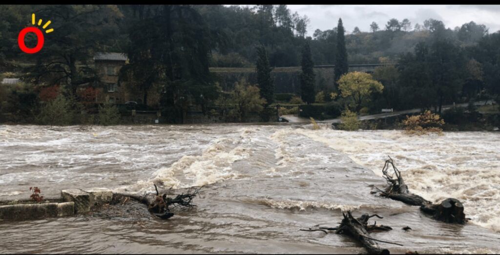
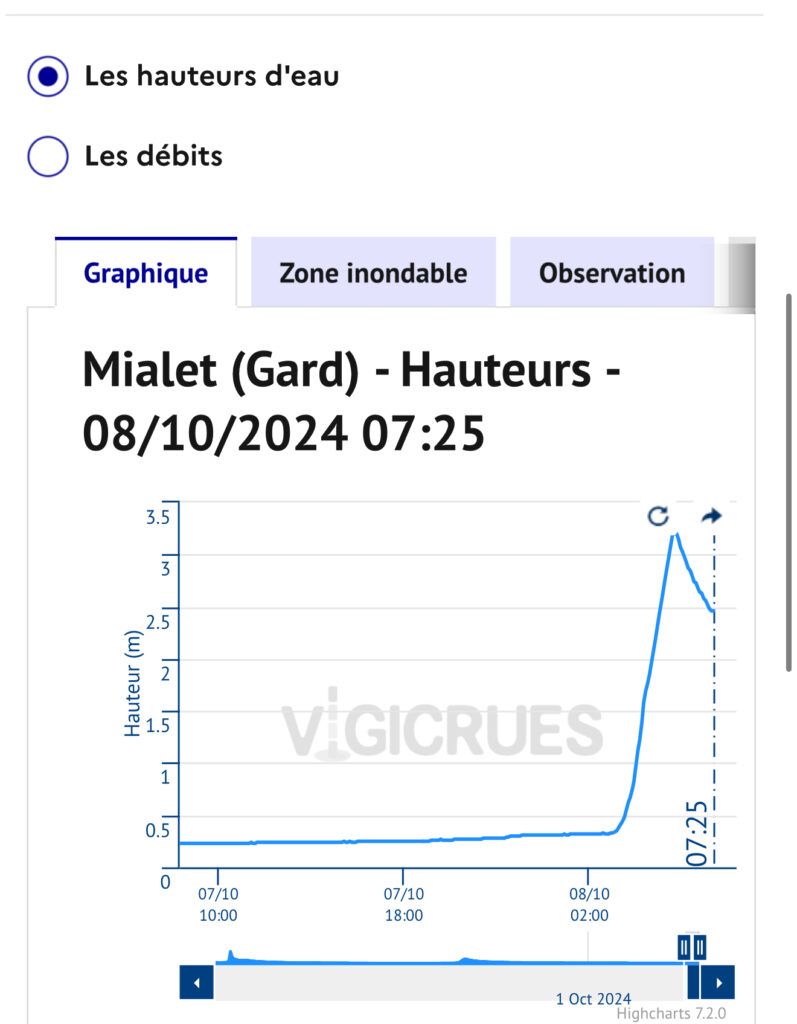
Heavy precipitation still in progress in Piedmont Cévennes where the accumulations reach the 150 à 180 mm from the beginning of the episode. This is particularly the case in the surroundings of MialetSaint-Jean-du-Gard and La Grand Combe. THE Roach reached its peak at the end of the night with a level of 3.2 meters in Mialet after a flash flood. The flood is spreading downstream in the Anduze sector. The Gardon d’Alès is also in flood. Several submersible bridges are closed to traffic by the roads department of the Gard Departmental Council.
The Cèze is also in flood this Tuesday morning with propagation downstream from Bessèges to Saint-Ambroix at the moment. The rain-storm system crosses the Gard plains this Tuesday morning. It arrives in the Alésien Basin by 8:00 a.m., then shifts towards Gardonnenque by around 9:00 a.m. and rather by 9:30 a.m. in Nîmes. During its passage, high rainfall intensities.
Update at 6:30 a.m.:
Little development. The axis of heavy stormy rain is well in place over the Piedmont of the Cévennes. It slowly shifts towards the plains during the morning. River flooding continues.
Update at 5:30 a.m.:
The nouveau rain-storm system is gradually organized from the Hauts-Hérault cantons to Cévennes. Precipitation will increase in the Cévennes Piedmont and Alésien basin in the next hour. This system will sweep east of Hérault and the Gard (including the plains) during the morning this Tuesday. We are still expecting locally significant amounts of rain and runoff as it passes. The Gardon is experiencing a fairly significant flood near Mialet and the surrounding area. Stay informed.
The weather update at 4:30 a.m.:
The first burst of rain and storms is coming to an end (persistent stormy rains in the Nîmes basin and Rhône valley) but be careful, the episode is not over. Rainstorm activity will resume late night or early morning. A new rain-storm line will form, in the same sectors of the East of Hérault a you Gard. She will cross the Languedoc slowly during the morning, from West to East. Rainfall accumulations have already reached, locally, 100 à 150 mm near the Cévennes. Be careful in the foothills of the Cévennes where rivers in flood can submerge submersible bridges and ford crossings.
Weather update at 3:45 a.m. – 4:05 a.m.
And torrential and not very mobile storm hits the Piedmont of the Cévennes (St Jean du Gard, Mialet, La Grand Combe, Bessèges, etc.). Very high rainfall intensities and significant accumulations in a short time. Be careful in this area, river floods to come. Heavy stormy precipitation extends towards Ardèche, the Alésien Basin and the plains of Gard. In Héraultonly the extreme east of the department is affected by the rains (near Vidourle). HAS 4h05precipitation settles between Petite-Camargue, the Nîmois basin, Vaunage and Gardonnenque. Between Lasalle, Saint-Jean-du-Gard et Mialethe fell 80 to 100 mm over the last hour ! Be careful of the very rapid reactions of the Gardons and their tributaries, in progress (fording to be avoided).
Update at 3:00 a.m.:
A very intense, linear rain-storm system is currently stretching from the east of Hérault to the Cévennes via the Cévennes Piedmont. It will gain towards the Alésien basin in the next hour. The precipitation is particularly intense under this storm with torrential intensities. Heavy showers are also circulating in Montpellier.
Update at 2:00 a.m.:
Rainstorm activity is clearly increasing in the north of the Hérault department as well as in Lozère. Thunderstorms are also circulating in the center of Hérault and heading towards the east of the department (and towards the north-west of Gard). At the same time, heavy stormy showers quickly formed in the Gard plains. Stay informed of developments. Below, real-time radar images.
Update at 1:00 a.m.:
Thunderstorms are progressing over the west and center of Hérault at the moment after having crossed locally part of Aude. And windy phenomenon intense very localized hit the commune of Lézignan-Corbières to the passage of a particularly virulent isolated storm cell. A burst has 158 km/h was recorded at 00:42! Rainfall intensities are high. The episode gets stronger little by little.
Forecast update at 9:00 p.m.
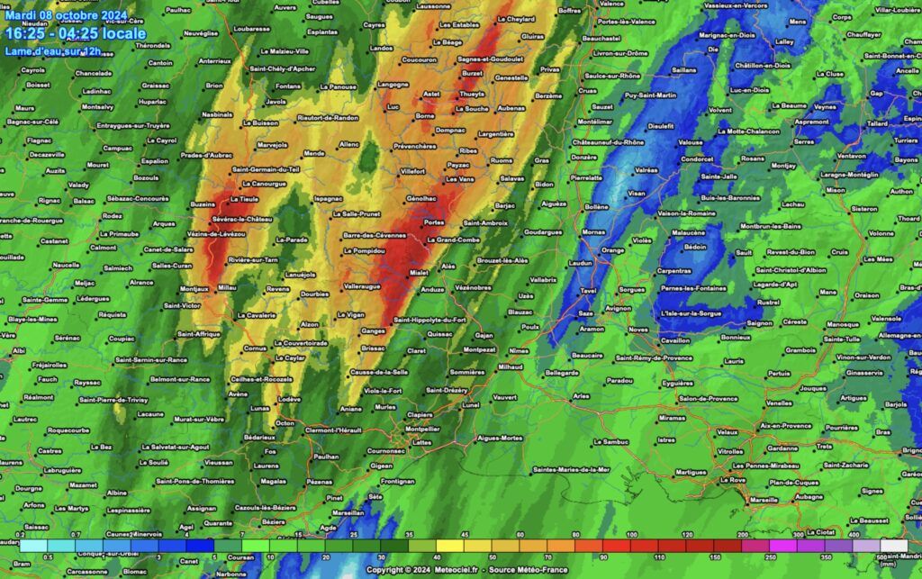
The initial weather forecasts are confirmed. During the evening, the precipitation increases. In the second part of the next night, they will become very strong on the Cévennes and gradually extend to the foothills then to the plains. Between 3/4 a.m. and 10 a.m. this Tuesday, October 8, torrential storms circulate slowly between eastern Hérault and Gard. They hit the Gard plains, all of the Cévennes and Ardèche, as well as the south of Lozère. In a few hours (3 hours to 6 hours), the rainfall totals reach 80 to 120 mm or locally 150 mm. By accumulation, the 200 mm can be reached or exceeded at the heart of the relief cévenol between Gard and Ardeche notably.
Of the floods of Cevennes rivers and their tributaries are to be feared. With a risk of submersion of ford crossings and submersible bridges. These must absolutely be avoided over the next few hours. Of the intense runoff are possible on the road network and in urban areas, particularly tonight and very early Tuesday morning. Indeed, there is a risk of torrential storms which could dump 50 to 80 mm of precipitation in just 1 hour in the plains of Gard. The episode ends late Tuesday morning for our region. Stay informed of weather developments live on our media.
Live precipitation radar