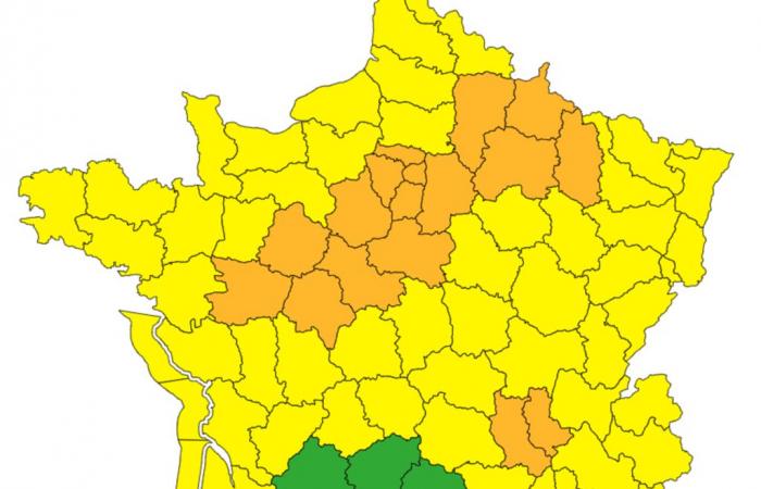
Twenty departments in France are on orange alert for the wind on Monday January 6, in connection with the Floriane disturbance on the Atlantic coast, according to Météo-France.
“With the approach of a disturbance on the Atlantic coasts, associated with the depression named Floriane, the wind will strengthen from Sunday evening in the Rhône valley until the end of Monday,” according to the bulletin from the weather forecast agency, which specifies that “Storm Floriane will circulate quickly but intensely during the day on Monday along an axis starting from Vendée [où la vigilance orange a été levée lundi matin] to the Ardennes via Ile-de-France ».
Are affected by orange vigilance: Maine-et-Loire, Indre-et-Loire, Sarthe, Loir-et-Cher, Loiret, Eure-et-Loir, Yvelines, Essonne, Val-d'Oise, Seine-Saint-Denis, Val-de-Marne, Hauts-de-Seine, Paris, Seine-et-Marne, Aisne, the Marne, the Meuse, the Ardennes, as well as the Loire and the Rhône.
Read also | Article reserved for our subscribers What will the climate look like in France at +4°C?
Read later
Storm Floriane was expected to enter the territory early Monday morning from the coast of Vendée with gusts of around 90 to 100 km/h, locally at 110 km/h. “It shifts towards the Paris region at midday then the North-Eastern regions at the start of the afternoon, before quickly evacuating towards Belgium”adds Météo-France.
According to Météo-France, “in the departments bordering the departments placed on orange alert, the wind could blow strongly without however requiring a change of alert color for the time being. It is therefore advisable to remain cautious and keep informed of the development of the next vigilance maps.”
Rail traffic disrupted
The SNCF announced a series of measures for the departments concerned, ranging from slowdowns on certain lines to the absence of service to certain stations, including “traffic stops” – preventive stops to prevent trains from being blocked in the middle. track, particularly due to falling trees. In Hauts-de-France, the SNCF will shut down certain portions of lines for a few hours at midday on Monday. The Paris-Laon lines (between Crépy and Laon), Tergnier-Laon, Creil-Beauvais and Boulogne-Dunkerque (from 11 a.m. to 1 p.m.) are affected.
“There will be no direct Paris-Limoges-Toulouse trains before 4 p.m., four direct Nantes-Bordeaux trains will be canceled, there will also be no TGV from Tours and Saint-Pierre-des- Body until 4 p.m. and no TGV service until 2 p.m. from Poitiers and Châtellerault stations »details a press release from SNCF Réseau.
The preventive “traffic stops” will also concern the Limoges-Angoulème lines until 1 p.m., Limoges-Vierzon until 5 p.m., Poitiers-La Rochelle, Etampes-Orléans, and Tours-Poitiers, at least part of the day. , as well as Nancy-Bar-le-Duc from 11 a.m. to 4 p.m.
In Ile-de-France, departing from Paris-Est, trains to Coulommiers, Provins, Esly, Crécy-la-Chapelle will be canceled between 11 a.m. and 4:30 p.m. “Reconnaissance runs by empty trains with SNCF Réseau agents on board equipped with chainsaws will be carried out at the end of this meteorological episode in order to allow the resumption of traffic in complete safety”specifies the SNCF. According to Météo-France, “in the vicinity of the Aisne, it is not excluded, at this stage, that the gusts could even locally reach 110 km/h”.


