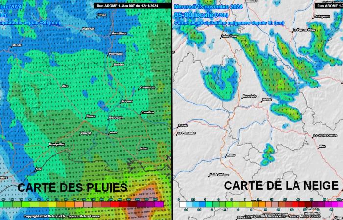
A return from the east with rain and snow is confirmed between this Tuesday afternoon and Wednesday morning. It will affect a large part of the region, causing snowfall on our mountains and moderate rain on our plains. Roussillon could be more watered, on its coastal part once again.
1) The first continental cold drop “in an easterly flow” of the season
We experienced an anticyclonic and exceptionally warm first decade of November. This Tuesday, a strong anticyclone stretches between the Azores and Great Britain. The atmospheric pressure is above 1040 hPa over Ireland. During the coming week, the anticyclone will pick up slightly towards Iceland. At the same time, the continental cold drop which formed at the start of the week over Germany passes over our Mediterranean regions this Tuesday.
It will then sweep Spain this Wednesday, then Portugal on Thursday. Good news: unlike the previous cold drop which turned out to be not very mobile, this one moves very quickly which allows the rain to not stay too long. We will still monitor the situation this Wednesday morning on the coast of Roussillon, due to watering which could prove significant. Here are the detailed forecasts for the next 24 hours regarding expected rain and snowfall.
2) A return from the East which begins with Gard and Lozère this afternoon:
The morning is calm. This Tuesday afternoon, the rains which affect Vaucluse and Bouches-du-Rhône approach Gard from the east (Rhône valley) then reach the entire department by the end of the day. The rains are moderate and cold since the thermometers will gradually drop to 7°C at the end of the afternoon in the hinterland. Precipitation reaches the Aigoual massif, the Cévennes, Mont-Lozère and Margeride at the end of the afternoon. It snows from around 1100 m altitude. The rains are gradually overflowing towards eastern Hérault: Montpellier, Lunel, Pic Saint-Loup and as far as Larzac.
This evening, the rains gradually stop in the East Gard but persist for a longer period in the South and West of the department, but also in the East of Hérault. It continues to snow on Aigoual and Mont-Lozère, but also more irregularly on Aubrac and Margeride. A few centimeters are likely above 1200 m, probably 5/10 cm on the Aigoual + Mont-Lozère summits. On our plains, watering often reaches 5/10 mm, but sometimes 15/25 mm in the south of Gard and Est Hérault. Below, the maps of rainy totals + snowy totals (not to be taken PERFECTLY literally) :
3) Continuation of the episode between the night and this Wednesday morning:
During the evening and ESPECIALLY during the night, the rains weaken but reach West Hérault and the coast of Aude, notably between Biterrois, Minervois, Espinouse, Montagne Noire, Corbières maritimes / Narbonnais and as far as Leucate. The Audois interior is not or only very little concerned. A new activation phase is possible in the Pyrénées-Orientales this Wednesday morning. As in the previous episode: the further we go towards the seaside, the more the accumulations can be copious (very heterogeneous range, but several tens of millimeters are possible).
Conversely, the further inland we go, the less plentiful they will be despite widespread watering. It snows temporarily from 1500/1700 m then the rain/snow limit rises during the morning around 1900/2000 m (Cerdagne, Capcir/Puymorens, Canigou). Rain may persist near the border until early/mid afternoon. There are uncertainties about the expected accumulations in the area which vary greatly from one model to another but we are retaining the option of generous watering on the coastal plains and the border range, less from Conflent to Fenouillèdes.
Facebook
Twitter
Google+


