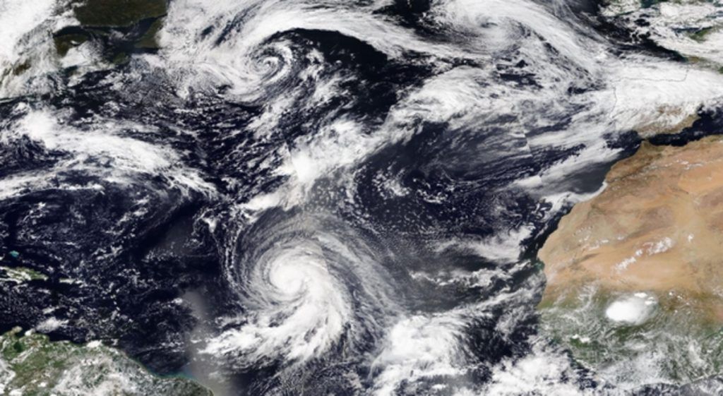
While the hurricane season has remained modest so far in the Atlantic despite the violence ofHelene At the end of September, activity regained strength with numerous phenomena forming in the middle of the ocean: Isaac, Joyce, Kirk and now Leslie. These go directly north, so that they remain in the open sea and do not threaten any land. But as they continue to head north, they encounter the westerly flow which crosses the Atlantic, which will propel them towards Western Europe next week.
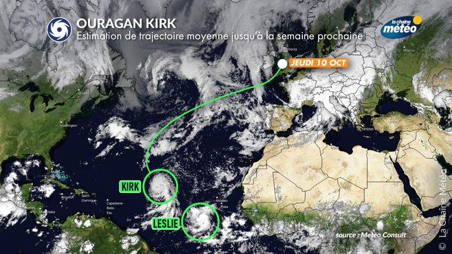
Current path of Hurricane Kirk © The Weather Channel
A parade of former hurricanes of which Kirk is said to be the strongest in Europe
Among the hypotheses, Hurricane Kirk could head towards the British Isles © The Weather Channel
The first ex-phenomenon to hit Europe will be Joyce in Ireland on Monday. Having once again become a simple depression in temperate latitudes, Joyce will cause a southerly flow which will bring great sweetness on our country as well as heavy rains in the southeastcoming up from the Mediterranean.
Then, Kirk will slowly arrive at the rear, passing north of the Azores on Monday, in category 1 or 2, causing heavy rain and large swells on this archipelago. Also progressing towards the British Isles, it could cause a strong storm over Ireland and England on Thursday. This situation will need to be monitored, because the low pressure core would be very hollow (between 965 and 970 hPa).
What effects to expect in France?
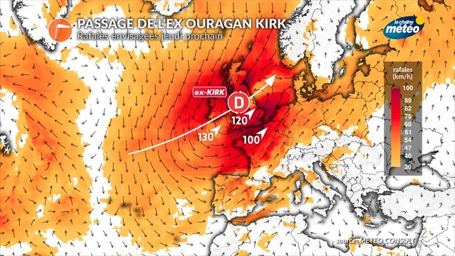
Ex-Hurricane Kirk passes next Thursday © The Weather Channel
If the trajectory does not change between now and then, the north-west quarter of France would be the most exposed next Thursday, with rain and a strong gale. The threshold of the storm could be reached along the coast of the English Channel.
The intensity of the winds will depend on two factors: the deepening of the depression (its minimum pressure) and especially the trajectory of the passage of the depression core. If it goes further north on the British Isles, our country would be less affected, because it is further away. But if it circulates across the Channel, our country would then experience stronger winds.
To date, and taking into account the modeling, the most likely trajectory would be from Ireland to the north of England. This intermediate scenario would then cause a strong gale from Brittany to Nord-Pas-de-Calais with gusts from the southwest sector reaching 120 to 130 km/h on the coasts, and around 100 km/h in the land in these areas. This strong gale, even storm, will be accompanied by heavy rain and heavy downpours. The sea will be rough with the arrival of cyclonic swells of 8 to 10 m in the Bay of Biscay. The tidal coefficients will be very low (around 40), which will minimize the risk of coastal submergence. The fact remains that at this deadline, many uncertainties persist, with certain scenarios seeing a trajectory towards Spain, others rather towards France and others towards the British Islands, reliability is therefore still very limited. We will specify the evolution of this tropical system in the updating of our next bulletins.
History on the British Isles
Remember that the return of old hurricanes to the British Isles is not uncommon at this time of year. The last strongest is Ophelia in October 2017 et Item in October 2023. Further afield, In 1961, Hurricane Debbie hit Ireland as a category 1/5, killing 18 people and causing millions of dollars in damage.
The north-west of France had been devastated by “the hurricane of 1987” in mid-October. But it was in reality a usual Atlantic depression which exploded on contact with a remnant of an old tropical storm under the influence of a jet stream very powerful. This is not the same system that is expected next week.


