Christophe Glass: French-speaking Switzerland can be divided into several zones. The first includes Geneva, western Lake Geneva, the Vaudois Jura and part of the Neuchâtel Jura. First, you have to prepare to face hail and gusts of more than 100 km/h. Then, between mid-afternoon and late evening, very heavy accumulations of rain are expected. The Valais Alps will also be exposed to heavy precipitation. In this zone, it is more the accumulations of rain that will pose a problem since they are added to the melting ice. This situation risks causing rivers to overflow by this evening. Finally, the canton of Jura and the north of the canton of Fribourg will, for their part, be more heavily affected by hail and gusts of wind. On the other hand, there is no major risk of flooding in this sector.
This Saturday, June 29: No fan zones this Saturday afternoon: Geneva cancels all event permits
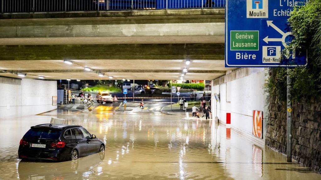
Many people still have in mind the spectacular images of the floods in Valais last week or of Morges on Tuesday evening. Should we fear the worst?
We must prepare ourselves to relive this type of situation, perhaps even worse. I’m not saying that it will necessarily be in Morges but every town in the Lake Geneva region must be ready. Between Lausanne and Geneva everything is possible. There are extreme scenarios that predict between 100 to 150 millimeters of precipitation.
Which could result in…
Widespread flooding, cellars and car parks buried by water in built-up areas, rivers like the Morges or the Venoge that could burst their banks… But at the moment, we have to imagine a jet of water heading north. The band is narrow and the precipitation will occur somewhere between eastern France and Lausanne. If it suddenly hits nearby, we could escape the worst and therefore brush against Geneva. There is a margin of uncertainty that must be taken into account. But for the regions that will be under this band, it is almost certain that there will be damage, given the amount of humidity in the air, the instability and the dynamism that we are experiencing.
Why are we faced with extreme flood risks several times in such a short time?
When we look at a weather situation, we have to look a little further than the end of our noses. In June 2021, there were floods of this type in Germany. If we zoom out a little, these phenomena are much less rare. What is true is that if we look at instability, we are in extreme values that we do not see often. However, it is difficult to make a link with global warming when we are talking about one-off extreme events such as storms. Projections indicate that we are heading towards stronger events. Are we there already? I don’t know.
Can you reassure people that summer won’t be completely ruined by the weather?
In the next ten days, we don’t see the good weather settling in for a long time. There is no lasting anticyclone on our radars. We’re heading back to an improvement in the middle of the week and then a new deterioration. Afterwards, I still think that by the end of August the good weather will finally arrive. Afterwards, you have to know that when an anticyclone sets in, we might be in another extreme with heatwave and drought. These are often systems that can set in for weeks.
What advice do you give people for tonight?
You should avoid walks in the forest and near watercourses. Especially streams in the Alps and Pre-Alps, as their level can increase drastically in just a few seconds. We also see that the authorities are taking measures and issuing a certain number of recommendations and I think that the best advice to give to the population is to refer to them and respect them.


