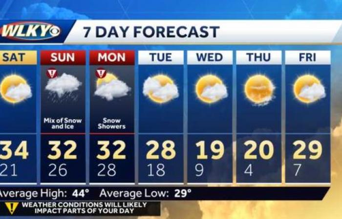
Follow live updates here: 2:30 p.m. – There are only 6 flights still scheduled to depart from SDF today, and they have all been delayed. Every other flight has been cancelled.2:10 p.m. – Mayor Greenberg tweets out update on emergency services. 1:44 p.m. – Gov. Beshear provides update on winter weather response from the Emergency Operations Center in Frankfort.12:15 p.m. – JCPS calls out school for Monday.12:05 p.m. – TARC service to Indiana is suspended for now.10:52 a.m. – At least 30 flights out of SDF have been canceled, 7 have been delayed. Check status here.10:41 a.m. – Reminder, snow is expected to fall for several more hours. 10:19 a.m. – LMPD advising anyone in a non-injury collision to use an online form, instead of calling 911. Click here.10:08 a.m. – NWS reports 3 inches of snow has fallen at SDF airport in Louisville.10 a.m. – Roads are snow covered and treacherous, several accidents reported.9:05 a.m. – TARC is now operating on its Winter Weather Detours. Updated information can be found here.8:30 a.m. – From Jay Cardosi: “An intense snowfall band is developing, we have upped the amounts a little bit for areas to the south of Louisville. If this band is as intense as what a couple of models are advertising, wouldn’t be a bit surprised to see upwards of a foot in a few locations from near I-64 and points north.”8:15 a.m. – Snow is already starting to stick across the region.Road conditions: Kentucky & Indiana7:43 a.m. – We’re already starting to see light accumulations in the Louisville Metro region.A winter storm warning is in effect from early Sunday to Monday evening. CLOSURES | INTERACTIVE RADAR | ACTIVE WEATHER ALERTSThe season’s first major winter storm is here, with a wide range of potentially treacherous impacts, including dangerous ice and a lot of snow over a two-day period.Emergency officials are asking people to stay off the roads unless necessary.Snow is expected to start in the early to mid morning hours. This band of snow will likely be moderate to heavy and could bring several inches of snow. Sunday afternoon into the evening, the snow will change to sleet and then freezing rain. A large zone of freezing rain is expected over southern Indiana and north central Kentucky, including the Louisville Metro area where substantial icing will be possible. With winds expected to become rather gusty, power outages are on the table. Check power outages: Duke | LG&EAs temperatures continue to warm, any freezing rain will change over to rain especially across southern parts of Kentucky Sunday night. As we move into Monday, areas of drizzle and freezing rain will be common, but as the upper energy of this system moves through, another band of light to at times, moderate snow will develop Monday morning and continue into the midday hours. Download the WLKY app for up-to-date weather alertsStream weather from WLKY anytime on Very LocalThis band will have the potential to produce a couple of more inches of snow. TOTALS: When you add up the snow/sleet that we’re expecting Sunday and Monday, 5 to 6 inches looks like a pretty good bet in the metro with heavier totals to the north and lighter amounts as you head south. In terms of ice, the greatest concern of this whole storm is going to be near and south of the I-64 corridor. A 1/4 of an inch to a 3/4 of an inch is expected. The ice has the potential to cause power outages and road issues. And what falls will stick around, as temperatures will stay well below freezing in the days following — we’re talking bitter cold, sometimes in the single digits — so you can expect the impacts to last.
Follow live updates here:
2:30 p.m. – There are only 6 flights still scheduled to depart from SDF today, and they have all been delayed. Every other flight has been cancelled.
2:10 p.m. – Mayor Greenberg tweets out update on emergency services.
This content is imported from Twitter.
You may be able to find the same content in another format, or you may be able to find more information, at their web site.
1:44 p.m. – Gov. Beshear provides update on winter weather response from the Emergency Operations Center in Frankfort.
This content is imported from Twitter.
You may be able to find the same content in another format, or you may be able to find more information, at their web site.
12:15 p.m. – JCPS calls out school for Monday.
12:05 p.m. – TARC service to Indiana is suspended for now.
10:52 a.m. – At least 30 flights out of SDF have been canceled, 7 have been delayed. Check status here.
10:41 a.m. – Reminder, snow is expected to fall for several more hours.
10:19 a.m. – LMPD advising anyone in a non-injury collision to use an online form, instead of calling 911. Click here.
10:08 a.m. – NWS reports 3 inches of snow has fallen at SDF airport in Louisville.
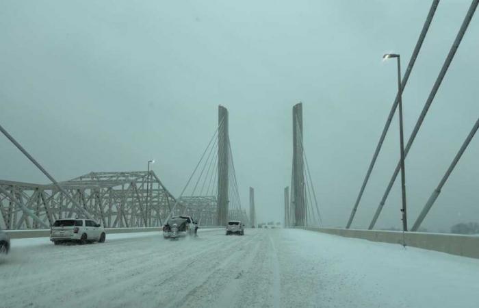
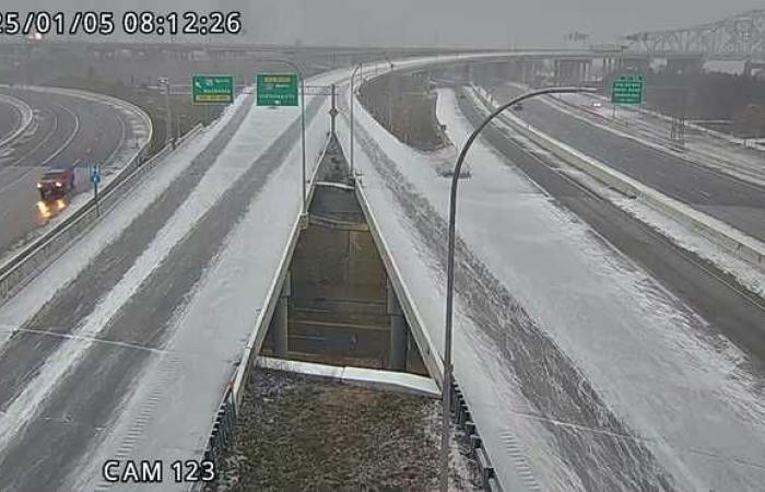
10 a.m. – Roads are snow covered and treacherous, several accidents reported.
9:05 a.m. – TARC is now operating on its Winter Weather Detours. Updated information can be found here.
8:30 a.m. – From Jay Cardosi: “An intense snowfall band is developing, we have upped the amounts a little bit for areas to the south of Louisville. If this band is as intense as what a couple of models are advertising, wouldn’t be a bit surprised to see upwards of a foot in a few locations from near I-64 and points north.”
8:15 a.m. – Snow is already starting to stick across the region.
TRIMARC
Road conditions: Kentucky & Indiana
7:43 a.m. – We’re already starting to see light accumulations in the Louisville Metro region.
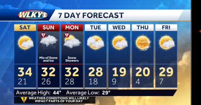
A winter storm warning is in effect from early Sunday to Monday evening.
CLOSURES | INTERACTIVE RADAR | ACTIVE WEATHER ALERTS
The season’s first major winter storm is here, with a wide range of potentially treacherous impacts, including dangerous ice and a lot of snow over a two-day period.
Emergency officials are asking people to stay off the roads unless necessary.
Snow is expected to start in the early to mid morning hours.
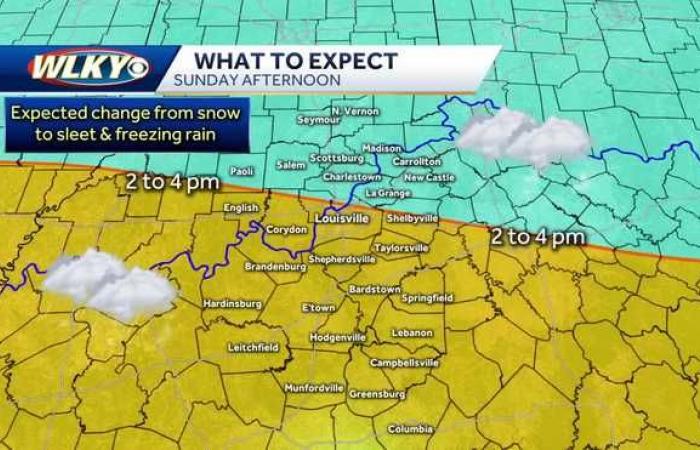
This band of snow will likely be moderate to heavy and could bring several inches of snow. Sunday afternoon into the evening, the snow will change to sleet and then freezing rain.
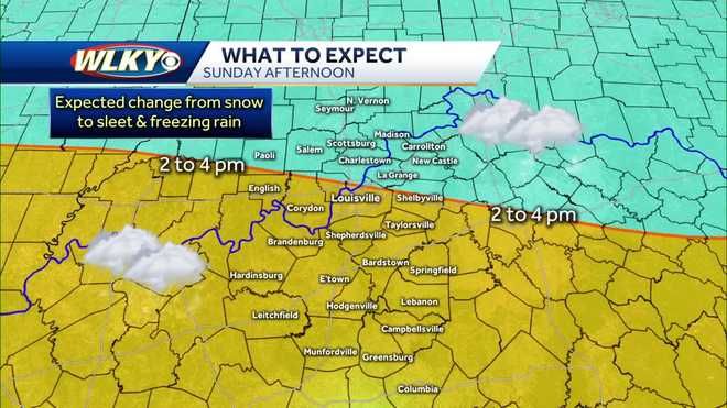
A large zone of freezing rain is expected over southern Indiana and north central Kentucky, including the Louisville Metro area where substantial icing will be possible.
With winds expected to become rather gusty, power outages are on the table.
Check power outages: Duke | LG&E
As temperatures continue to warm, any freezing rain will change over to rain especially across southern parts of Kentucky Sunday night.
As we move into Monday, areas of drizzle and freezing rain will be common, but as the upper energy of this system moves through, another band of light to at times, moderate snow will develop Monday morning and continue into the midday hours.
This band will have the potential to produce a couple of more inches of snow.
TOTALS: When you add up the snow/sleet that we’re expecting Sunday and Monday, 5 to 6 inches looks like a pretty good bet in the metro with heavier totals to the north and lighter amounts as you head south.
In terms of ice, the greatest concern of this whole storm is going to be near and south of the I-64 corridor.
A 1/4 of an inch to a 3/4 of an inch is expected. The ice has the potential to cause power outages and road issues.
And what falls will stick around, as temperatures will stay well below freezing in the days following — we’re talking bitter cold, sometimes in the single digits — so you can expect the impacts to last.
