CNN
—
A historically strong bomb cyclone, which triggered winds that killed at least two people, is working with a powerful atmospheric river to bring heavy rain, potential flooding, gusty winds and mountain snow across Northern California and the Pacific Northwest – and another system may be on the way.
The combined effects of the weather systems triggered a rare, high risk for excessive rainfall, or a level 4 of 4, across northwestern California through Thursday, according to the Weather Prediction Center.
Widespread rainfall of 3 to 5 inches with isolated totals of more than eight inches are possible across the region. Combined with rainfall from Wednesday, a potentially record-breaking 16 inches or more of rainfall is possible through Thursday.
Mountain snowfall will also continue across the northern Sierra Nevada and Oregon Cascades through Thursday morning, where storms are expected to bring one to two feet of snow.
Residents by California’s Pacific shore were filling sandbags Wednesday in preparation for heavier showers and potential flooding. The area was also battered by high winds from the bomb cyclone that wreaked havoc on the Pacific Northwest this week, including a 98 mph gust near the coast in Humboldt County.
About a dozen small landslides have already struck across northern California in a 24-hour period, including one on Highway 281 Wednesday morning that caused a vehicle crash, according to the Associated Press.
Authorities in the state were also struggling to identify flooded roads overnight, Cal Fire warned, in a post on X. These inland roads, also coated with snow, have created slick conditions that could make driving treacherous.
“Remember to slow down and drive cautiously in these hazardous conditions,” Cal Fire said. “Ensure your windshield wiper blades are in good condition, use your headlights for better visibility, and increase the distance between your vehicle and others on the road.”
As the deadly bomb cyclone helping to fuel the atmospheric river moves away from the coast Thursday, the National Weather Service is monitoring another low-pressure system that has the potential to strengthen on the heels of the first one.
This new low-pressure system is expected to move toward the Northwest coast Friday and undergo strengthening. This low is expected to “bomb out” or undergo “bombogenesis,” which is the decrease in pressure of 24 millibars in 24 hours.
Forecasters, however, remain skeptical this storm will bring the same impacts as the bomb cyclone that is moving away from the Pacific Northwest.
“Another deep surface low is expected to track towards our region offshore early in the morning,” the weather service office in Seattle warned. “Want to iterate to the public that the impacts are not expected to be as widespread as with the low earlier in the week (winds will be lighter out of the south, and precipitation amounts will be lighter),” the office said.
Conditions are improving in Washington as the first storm moves away from the coastline. All blizzard warnings have expired for the Cascades, with the remainder of winter weather alerts expiring Thursday morning.
Energy outages in the state have also improved, though nearly 350,000 customers in Washington are still without power as of late early Thursday, according to PowerOutage.us.
Even without making landfall, bomb cyclones can be deadly
Although the first storm never made landfall, historic bomb cyclones can still bring devastating effects.
At least two people were killed in Washington state from strong winds that pushed down fallen trees. One, a woman in her 50s in Lynnwood, north of Seattle, and another – killed while showering in her King County home, according to the Bellevue Fire Department.
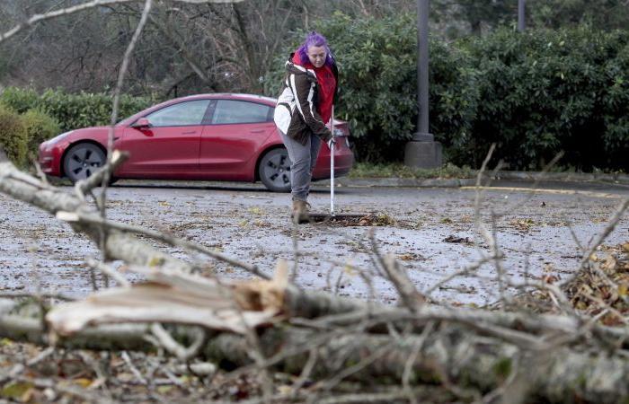
Video shows extensive damage to trees, powerlines and homes across the state, where police and fire workers have been working to remove tree debris scattered across roads, on top of cars and a leaking propane tank.
Some utility crews have also been struggling to restore power but have limited access to hard-hit areas because of blocked roads and mudslides.
Southeast of Seattle, two people in Maple Valley were rescued and taken to a nearby hospital after a tree fell on their trailer. While one person was freed quickly, it took firefighters an hour to extricate the second, according to Puget Sound Fire.
The storm was “one of the worst windstorms we’ve had in recent memory,” Issaquah Mayor Mary Lou Pauly said Wednesday. “We are seeing significant damage from trees (and) most of our traffic signals are out.”
A tree slammed into Washington resident Rob Corcoran’s home Tuesday evening and when it did, he told CNN it sounded like a jet landing on his roof.
“I didn’t even go outside because I was scared, I could be hit with flying debris,” Corcoran said. “I had no idea it was as bad as it is.”
An Amtrak train en route from Vancouver collided with a fallen tree on tracks north of Seattle Tuesday night, according to a statement from Amtrak. No injuries were reported among the 48 passengers on board and they were able to complete their journeys via alternate transportation. One engineer was hospitalized for evaluation and later released, according to Amtrak.
A waterspout was also spotted off the coast in south Washington Wednesday afternoon, according to National Weather Service’s Portland office, but didn’t appear to make on to land.
While the second storm is currently forecasted to be less severe than the first, soils are becoming more saturated across the Northwest.
With even more rainfall and flooding, the soil will become too saturated and rivers will begin to rise to more dangerous levels. The land’s natural defenses against excessive rainfall will begin to be unable to hold excess moisture which can lead to more runoff and flooding in future events.
CNN’s Isaac Yee, Hanna Park, Sara Smart, Andy Rose, Mike Madrigal and Taylor Romine contributed to this report.


