Highlights:
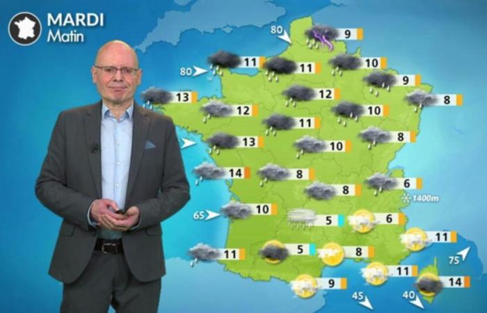
– heavy rains over the north-eastern half, descending towards the central regions in the evening.
– Strong winds especially from the Atlantic coast towards the northeast of the country
– seasonal temperatures despite a very gloomy feeling
– sudden drop in temperatures north of the Loire at the end of the afternoon
– Heavy snowfall at increasingly lower altitudes in the evening and at night in the center-east
An active cold front will cross France from north to south this Tuesday © The Weather Channel
Matin :
Driving rain and strong winds affect the northern two-thirds of the country, especially north of the Loire. Although temperatures are quite mild in the morning, the feeling is gloomy. Gray weather with scattered light rain also affects Aquitaine, Franche-Comté and the Northern Alps. Only the extreme south, from the Pyrenees to the edge of the Mediterranean, retains mild weather.
Minimum temperatures, temporarily rising, are 5 to 13°C.
Afternoon
It's raining steadily north of the Loire but the wind is weakening there. Temperatures plateau and will drop late in the afternoon when the rain stops.
From the Atlantic arc to the Grand Est and Franche-Comté, the wind blows strongly with gusts of 80 km/h inland and driving rain. The rain and snow limit remains around 1400 m before the sudden drop expected in the evening.
From the Pyrenees to the southern Alps and around the Mediterranean, the weather is nice and mild.
Maximum temperatures are 9 to 12°C (like in the morning), but 15 to 18°C in the far south.
Soirée
Be careful of the degraded weather conditions from Gironde to the Grand Est, with rain and strong winds. But above all, watch out for the rapid fall of the snow in the late evening and night around 700 to 800 m on the Vosges and the Jura, reaching the Northern Alps and the central massif during the night. North of the Loire, the rains stop but it is cold. You will also have to be wary of the risk of frost and black ice on the secondary network on Wednesday morning.
Further trend
On Wednesday, it will be cold and dry in the northern half. A few showers of snow will occur as far as the plains between the Central massif, Franche-Comté and the northern Alps. In the southwest, it will be less cold in the southwest while a strong wind will blow in the southeast.
On Thursday, a new disturbance coming from the Atlantic could cause an episode of snow at very low altitude or even in the plains, especially in the center-east.


