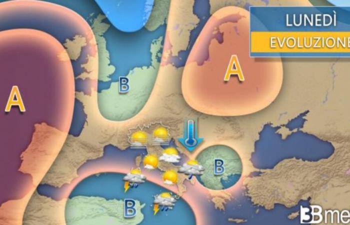
After unusual sun (and heat) for the month of October and the beginning of November, a deterioration is expected in our country from next week. Rain, thunderstorms, and especially a drop in temperatures will sweep away the heat of recent weeks. The low-pressure area that will continue to bring showers and thunderstorms to parts of the South over the course of Sunday will be the starting point for the more widespread deterioration expected in Italy over the next week.
Cold Air from the North Sea
As explained by 3B Meteo, the unstable circulation will be hooked and invigorated by an impulse of cold air coming from the North Sea, which will cross Western Europe and enter the Mediterranean near the Gulf of Lion on Tuesday. “The way this new depressionary circulation will develop is not yet entirely clear. The models lean towards a direction of the disturbed currents more towards Southwestern Europe, with greater involvement of Spain and France, but Italy will also be part of the unstable pattern,” explains Carlo Migliore on 3B Meteo.
Monday, St. Martin’s Summer
On Monday, the day of “St. Martin’s Summer,” little will change compared to the weekend. The area of instability will still be predominantly concentrated at low latitudes, so we will have showers and thunderstorms, locally even intense, on the major islands, while the rest of the Peninsula will have decent weather with more cloud cover on the mid-lower Adriatic where some mild phenomena are expected. Temperatures are expected to slightly decrease.
Rain and Thunderstorms from Tuesday
On Tuesday, the impulse of cold air will enter the Mediterranean, widening the area of instability to parts of the Central-North, especially the Northwest and the Southern Peninsula. Rain and showers are expected, with thunderstorms and locally strong intensity, with details we can only provide on Monday. Temperatures will drop a few more points.
Cold Air on Central-Western and Southern Europe
On Wednesday, the feed of cold air from Northern Europe will close, and a very large depressionary area extending from Spain to the Balkans will be active over Central-Western and Southern Europe. In this phase, the rains and showers should mainly affect the Center and South of the Peninsula, but the evolution is still unclear.
The Second Part of the Week
In the second part of the week, Italy will still be part of an unstable circulation that will renew showers and local thunderstorms in some areas. The uncertainty of the evolution does not allow us to define any preliminary details. Temperatures should return to normal for the period across the country. Updates will follow.
© ALL RIGHTS RESERVED
This article is automatically translated


