For the second time in less than two weeks, Ernst Bontemps attaches wooden boards to the windows of his clinic in Saint Petersburg in west Florida. His town, devastated by Hurricane Helene, is in Milton’s path.
“It’s too much,” sighs this 61-year-old gastroenterologist. “It’s really hard because we have already seen our city completely devastated” not long ago and “it’s starting again,” he despairs.
Hurricane Milton is expected to make landfall in this southeastern American state, the third most populous in the United States, during the night from Wednesday to Thursday. But violent winds will precede it, the hurricane having passed Monday into category 5 – the highest – off the coast of Mexico.
Tampa Bay, which includes the city of the same name and those of Saint Petersburg and Clearwater, has not yet recovered from Hurricane Helen, which caused at least 230 deaths in the southeast of the United States, including minus 15 in Florida and made landfall as a Category 4 hurricane.
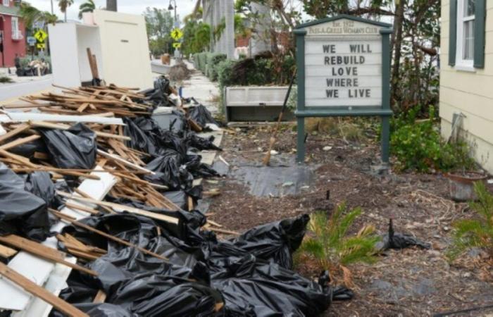
On the front line before Saint Petersburg: Treasure Island, a small island of 6,500 inhabitants in the Gulf of Mexico, where the streets are still strewn with debris. The waves submerged homes and shops.
Many residents have taken out furniture that was badly damaged by the floods: beds, mattresses, refrigerators and televisions form piles in front of the houses.
In front of his, David Levitsky, a 69-year-old retiree, worries about the possibility that the winds will carry this furniture and land it “on who knows who in the street.”
Like his neighbors, he tries to protect what Hélène left him before preparing to evacuate to a safer area.
“Living by the sea is a joy, but of course, this joy comes with a lot of risks” which are much darker, he notes.
The American meteorological observatory warned at the end of May that the hurricane season, which extends from the beginning of June to the end of November, was expected to be an extraordinary year. By warming sea and ocean waters, climate change makes rapid intensification of storms more likely and increases the risk of more powerful hurricanes, scientists say.
“I’ve been here 22 years and we’ve never been hit twice in a row in one year. Since I’ve lived here, the summers have gotten hotter. The heat is less bearable. Something is happening,” recognizes Ernst Bontemps.
– Elephants and rhinos –
On the other side of the bay, about forty kilometers away, the city of Tampa and its 400,000 souls are preparing to experience the “worst storm to hit the region in more than 100 years” if it keeps its trajectory, according to local weather services.
Sandbags are piled up in front of doors to anticipate the sudden rise in water while the streets are clogged with residents looking to stock up on food and fuel, although the latter is becoming increasingly scarce.
In the midst of this agitation, Tiffany Burns prepares an evacuation of a completely different kind. Responsible for the animals at the Tampa Zoo, she must organize the movement of elephants, rhinoceroses and orangutans into buildings built to resist hurricanes.
“We hope that they will suffer as little as possible,” explains this 41-year-old woman.
Two veterinarians try to lure a porcupine into a cage using carrots and strawberries. Once enclosed, the animal is then carefully transported to dry areas using a golf cart.
Zoo staff are trying to stay positive but many are worried about their homes.
“It’s really hard to see such a big storm coming so soon after the last one,” laments Tiffany Burns.


