The mysteries of the forgotten cities of the Silk Road never cease to amaze us. The rediscovery of Tugunbulak and Tashbulak opens new perspectives on medieval town planning.
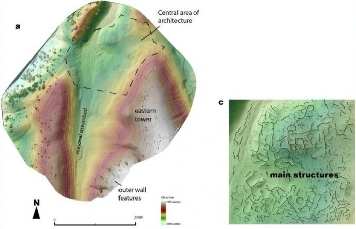
A team of researchers led by Michael Frachetti and Farhod Maksudov began their investigation more than a decade ago. Using drones and LiDAR technology, they revealed structures buried beneath mountainous landscapes. The images obtained immerse us in the history of commercial exchanges.
The LiDAR technique made it possible to map these difficult to access sites. Using this technology, researchers were able to identify complex structures, including fortifications and public spaces, revealing advanced urban organization.
Both cities are at an unusual altitude for urban settlements. At approximately 2,200 meters, Tugunbulak is the highest known medieval town inAsia central. This discovery prompts a review of the standards ofurbanisation in this region. Contrary to popular belief, trade routes actually crossed these mountains. The results of the study show that these cities were dynamic poles, driven by trade andcraftsmanshipbetween the 6th and 11th century A.D.
Tugunbulak, covering 120 hectares, was a real economic center. The first excavations indicate that this city was a place of metallurgical production, exploiting the surrounding resources. This may have contributed to its development and prosperity.
Tashbulak, although smaller, had a unique cemetery, testifying to the rise of Islam in the region. Its oldest tombs reveal a strong spiritual connection, attracting individuals from diverse backgrounds.
The reasons for the abandonment of these cities remain unknown. No signs of destruction have been observed, leaving room for speculation about political or climatic changes that may have influenced their decline.
The rediscovery of Tugunbulak and Tashbulak shakes up our understanding of medieval civilizations. These long-neglected mountain towns highlight the diversity of Central Asian societies.
What is LiDAR technology?
LiDAR technology, an acronym for “Light Detection and Ranging”, is a method of remote sensing which uses lasers to measure distances. By sending light pulses and analyzing the temps It takes for these pulses to return, LiDAR can create detailed 3D maps of landscapes.
This technology is particularly useful in difficult-to-access environments, such as mountainous areas. In archaeology, it helps reveal hidden structures, providing valuable information about previously inaccessible historical sites. Thanks to LiDAR, major discoveries, such as those of the medieval cities of Tugunbulak and Tashbulak, are now possible, changing our understanding of past civilizations.


