Although there are still many uncertainties about its exact trajectory and the strength of the winds in our country, we can already characterize this phenomenon which will affect France on Wednesday and Thursday.
An extra-tropical depression whose trajectory resembles that of Xynthia
Kirk will arrive at the stage of a strong extra tropical depression with very low pressure, forecast from 975 to 980 hPa. More common in winter, it is a fairly unusual pressure on our country, especially at this season. Remember that the pressure observed during the passage of the storm Xynthia in February 2010, which had approximately the same trajectory, was much lower, at 969 hPa.
In addition, during the passage of Xynthia, the tidal coefficients were very high (102). These high coefficients had contributed to a deadly marine submersion, which will not be the case at all this time, since they will only be 52/45 on Wednesday, and 40/34 on Thursday.
Storm warning for France
Maximum gusts expected © The Weather Channel
These low pressures as well as a tight pressure gradient (strong reduction in pressure around the low pressure center, visible by tight isobars on the maps), will generate stormy winds, both when arriving on the coast and inland, because the ex-Kirk should cross our country while maintaining its low pressures.
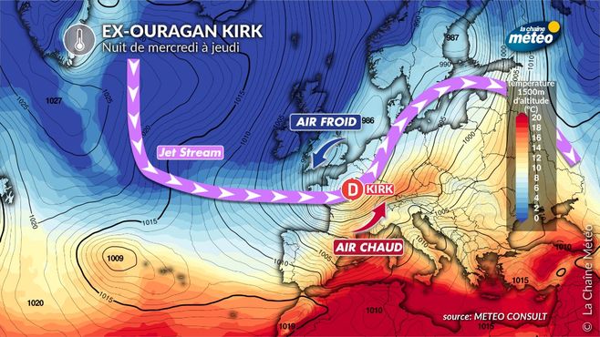
Some numerical models envisage a further deepening of this depression by progressing towards the northeast, which is atypical, and would be caused by the influx of cold air at the rear, further boosting the cyclogenesis process (formation of a depression).
A moderate jet stream, but a violent air mass conflict
The jet-stream constitutes a factor in the strengthening of storms, which occurred during the “hurricane of October 1987” in the north-west of France, and especially during the storms of December 1999.
In the situation this midweek, the jet should not be an aggravating factor. Indeed, although very fast currently (it is he who “sucks” Kirk towards Europe), it will soften on Wednesday and will become moderate when the depression passes. However, there is one parameter that will accentuate Kirk’s strength during his passage over our country: a powerful air mass conflict.
Indeed, Kirk will rise with warm air ahead (southwest flow), then cold air will rush towards Brittany, wrapping around the depression. This thermal shock then risks reinforcing the dynamism of this depression, which could deepen even further as it moves towards the north-east of France. It is also this situation which explains why the gusts could be so strong from the Atlantic to the northeast, which is atypical.
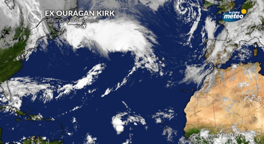
Ex-ouragan Kirk © La Chaine Meteo
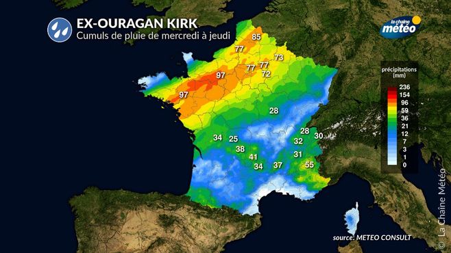
Heavy rainfall
Rainfall forecast © The Weather Channel
In addition to the stormy wind, Kirk will drain a atmospheric river from the subtropical Atlantic.
Heavy rains will therefore fall along the path of the depression, from the center-west to the north-east via the Paris basin, areas whose soils are already saturated with water. The risk of hydrological reaction will need to be monitored.
Strong cyclonic swell, but low tidal coefficients
Due to the fairly southern trajectory of the Kirk depression, which will rise from Cape Finisterre towards the Charentes, the cyclonic swell of 8 to 10 m will hit La Coruña (north-west of Spain) and the Portuguese coast. Our coasts in the south of Aquitaine will experience strong waves of 4 to 6 m, especially south of Gironde.
This context will occur with low tidal coefficients (around 40), which will limit the risk of submersion. However, due to low atmospheric pressure, a surge will occur, which may raise the water level compared to the theoretical tide. This phenomenon will be especially present at high tide on Wednesday evening, between the Pertuis Charentais and the Gironde estuary.