Between the warm air which will rise from the Maghreb and the Balkans and the cool air of Atlantic origin, a return to calm is not expected this week. Several stormy waves are expected in the country.
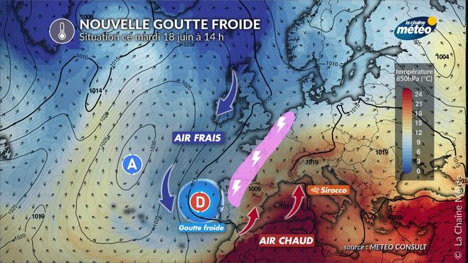
This situation is caused by a new “cold drop” which broke off from the North Atlantic and which plunged down to the level of Portugal. Its rotating movement causes the rise of very hot air coming from the Sahara and brushing against the south-east of France. With the proximity of fresh Atlantic air, several stormy waves will occur over France.
General situation this Tuesday © gmatricon
Tuesday, between strong storms in the west and a big heat peak in the east
In the west and north, a disturbance will bring very rainy thunderstorms in the morning north of the Seine, which you should be wary of. In the east and south, it is the heat that will make the news. The maximums will reach and exceed 30°C from Strasbourg, Lyon, Toulouse and Grenoble to Avignon, with peaks at 38°C in Corsica, due to the sirocco effect.
Wednesday, strong heat in the east and new storms in the west
The weather will remain unstable and very stormy in the west. Near the English Channel, the weather will be calmer and cooler due to a fairly noticeable northeast wind. To the east and south of a Strasbourg / Clermont-Ferrand / Limoges / Bordeaux line, it will be very hot. The atmosphere will be heavy and tropical. 32 to 35°C will be reached occasionally in the lower Rhône valley to the south of Lyon and near Grenoble as well as in Corsica.
Thursday, generalization of storms towards the east
For this first day of calendar summer with the solstice, and with the progression of the cold drop towards Belgium through France, the very stormy weather will extend to 3/4 of the country, especially from the southwest to the borders from the northeast through the center of the country. These storms are expected to be very active again and accompanied by a risk of hail. In the northwest, the weather will be calmer and cooler. On the other hand, from the Alsace plain to Lyonnais, it will be very hot with 30 to 35°C in the afternoon, before the evening storms.
Friday, storms concentrate in the east, general cooling
While the weather will return calmer from the west, storms will extend from the Pyrenees to the Alps to Alsace, with the risk of violent phenomena possible east of the Rhine, the Saône and the Rhône where temperatures will drop more than 10°C compared to the day before.


