
The last hours of September 2024 still look relatively pleasant, but tomorrow, for the start of October, the pendulum will unfortunately swing. A wave of humid air will arrive from the west, with sometimes heavy rain, especially during the night from Tuesday to Wednesday. Then, the trough in terms of precipitation will be reached this week. With the arrival of the north wind on Thursday, cooler air will infiltrate Switzerland.
Smooth end of the month
Switzerland is on the southern edge of a stormy depression centered on England, in a westerly current. Behind a receding warm front, drier air temporarily reaches us this way. As a result, we can still look forward to a few hours of sunshine until tonightthere will generally only be harmless cloud fields. The southwest wind will strengthen a little further and, in combination with the sun, temperatures will reach 19 to 21 degrees. In Ticino, cloud cover is greater and temperatures are around 18 degrees. Next night, cloudiness will increase from the west.
Wetter and wetter with heavier and heavier rains
From the low mentioned above, a surge of humidity will reach us tomorrow, integrated with an air mass boundary. Mardithe sky will be very cloudy and the rain will extend from France. – Only the far east of the country will benefit from prolonged dry weather in the morning.
Fig. 1: Weather Tuesday – increasingly heavy rain from the west; Source: MeteoNews
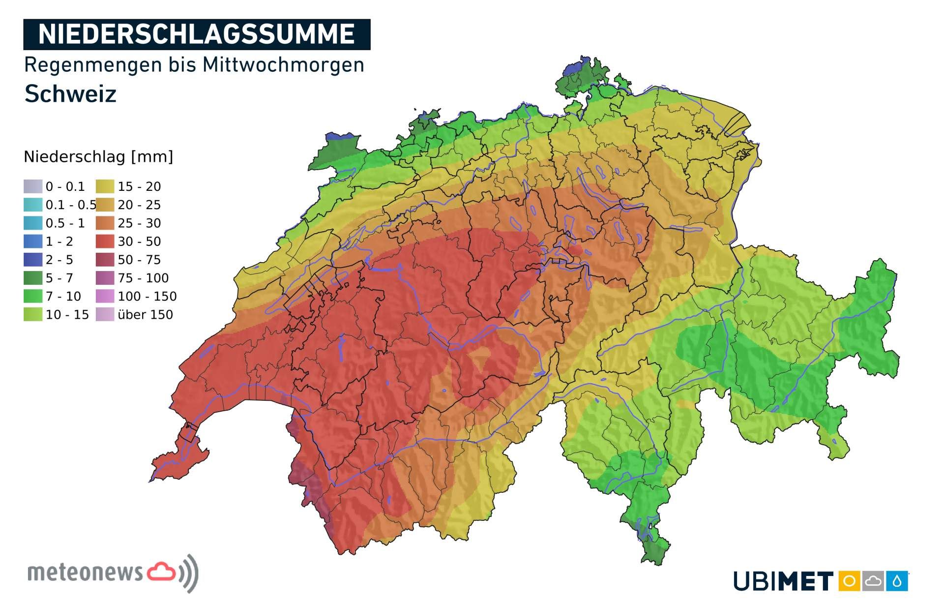
During the afternoon, the rain will begin to slowly intensify and the snowfall limit will rise to over 2500 meters. In the evening and the following night it will rain heavily at times and the snowfall limit will begin to slowly fall. By Wednesday morning, precipitation amounts will be significant! Most of it will be in the western half of the country, where we will record between 50 and 70 mm – locally a little more. Towards the east, the quantities are lower.
Fig. 2: Rain through Wednesday morning, heaviest in the western half of the country; Source: MeteoNews, Ubimet
A few showers only Wednesday
After a gloomy and humid night, the precipitation will ease early Wednesday morning. Wednesdaythe weather will be more variable with a mix of clouds, clear spells and occasional showers. Dry periods will be more numerous. Temperatures will be around 15 degrees and the snowfall limit will be around 2000 meters.
Autumnal freshness with a sensitive kiss
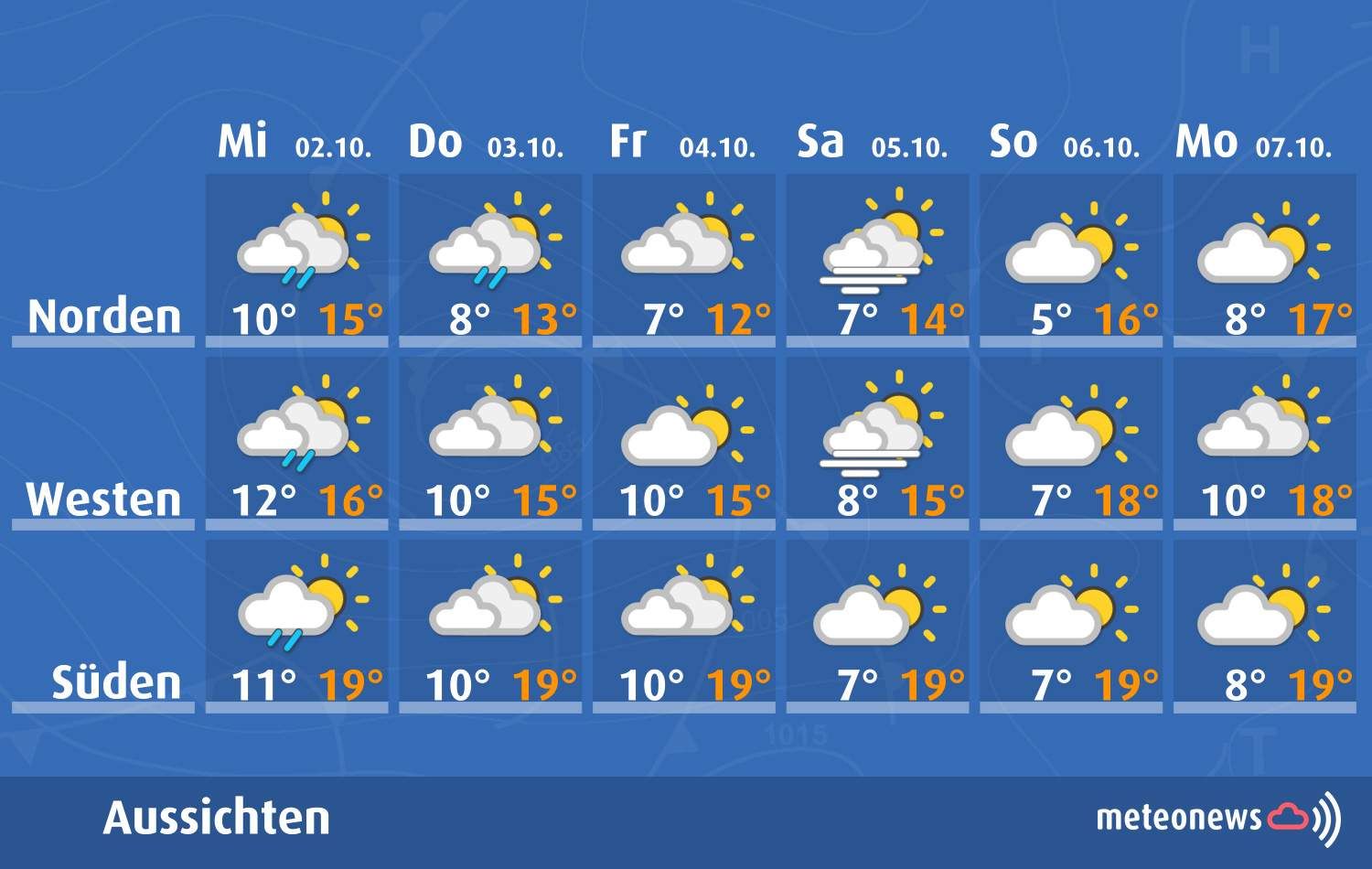
THURSDAYour country will find itself between an anticyclone on the North Sea and a depression in the Mediterranean, in a wind current, above which there will still be an altitude trough. With often significant cloudiness, a few showers will still be present, but the quantities and intensities will no longer be worth mentioning. Temperatures will drop, the weather will remain cool – the moderate wind will further reinforce this impression.
The same will go for the Fridaywhere it will be a little cooler and the wind will strengthen, often exceeding 60 km/h on the west of the Plateau and the Lake Geneva basin. It will have the merit of clearing the sky between Lake Geneva and Valais, while the further we go towards the north and east of Switzerland, the more clouds will remain.
Fig. 3: Outlook for the days to come; Source: MeteoNews
SATURDAYthe wind will ease and the air will become drier, especially at altitude. In the evening, we will be ahead of a marked depression centered over the North Atlantic. The current will move to the southwest, the zero degree isotherm will already rise to more than 3000 meters in French-speaking Switzerland. This development will continue Sunday with milder weather and a progressive foehn.
#Swiss


)