This Friday, November 22
08:30
Snow showers fall locally in Île-de-France, Normandy and Champagne-Ardenne. These flakes lightly sprinkle the already snow-covered ground on the plateaus and hills. But this does not hold on the main roads covered or in the Paris metropolitan area.
Traffic resumes very gradually but remains very slow. The few current showers of snow remain of no consequence.
07h30
Traffic conditions remain complicated on the roads that were covered in snow yesterday, but there are no significant new snowfalls. You must be wary of refreezing on roadways that are still wet and snow-covered on the secondary network. But this does not impact urban areas. On the other hand, the traffic routes which were blocked yesterday evening are still complicated after a difficult night for hundreds of motorists. The A36 motorway near Montbéliard (25) remains blocked. These vehicles have been blocked since yesterday evening, but little by little, motorists are able to leave after a sleepless night. It will no longer snow in this area from now on but it is -5°C.
07h05
This morning, showers of #snow and sleet are falling from #Normandy to Île-de-France and as far as the northeast. These showers are anecdotal and weak, but can sprinkle rural areas. This does not hold in urban areas or on the main roads treated.
06h30
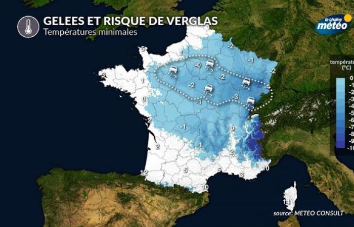
The frost is less severe than feared and the ice is therefore less widespread and less dangerous. The main roads are treated but the secondary network remains snow-covered. It will take time this morning to clear the roads still blocked this morning but the weather situation is improving.
Temperatures at 6:00 a.m. this morning © The Weather Channel
Thursday, November 21: snowfall and a record storm
At 9 p.m., This is the end of this follow-up. This evening, 230,000 homes were without electricity following snow and wind. Watch out for icy conditions tonight on snow-covered surfaces.
At 8:17 p.m.the snowy episode ends, but be careful of the risk of icy formation in the regions affected by snowfall this Thursday.
Risk of ice during the night from Thursday to Friday © The Weather Channel
A 19h50the snowy episode is now over from Normandy to Île-de-France. However, temperatures become negative and the risk of icy conditions is high. However, it continues to snow heavily in Franche Comté and southern Alsace as below in Hésingue (Haut-Rhin).
At 6:50 p.m.snowfall is gradually decreasing in intensity in the departments from Normandy to the Paris basin. On the other hand, it continues to snow more abundantly and continuously in the north of Burgundy and Franche-Comté. We sometimes find up to 25 cm in the Paris region, particularly north of Yvelines.
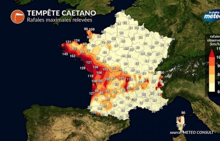
At 5:00 p.m.the storm is still blowing south of the depression with record gusts in the Massif Central, as in Superbesse with 136 km/h. Snow continues to fall at the same time from Normandy to the center-east.

Maximum gusts recorded at 5 p.m. (Caetano storm) © The Weather Channel
A 16h48snow continues to fall heavily in the Paris region at the time we leave the offices. We measure up to more than 15 cm in the suburbs, like at the Weather Channel near Orgeval.
A 15h42The snow front is almost standing still in the middle of the afternoon. The snowfall will soon stop in the English Channel but will continue for a few more hours from the interior of Normandy to Île-de-France then all evening in the Grand-Est and Franche-Comté.
A 15h36Nantes beats its record for wind gusts for the month of November with 121 km/h.
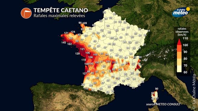
Storm Caetano (maximum gusts) © The Weather Channel
At 2:39 p.m.gusts exceed 150 km/h on the coast, as in Brittany, where a gust of 162 km/h was recorded at 1 p.m. on the island of Groix, which constitutes a monthly record.

Maximum bursts © The Weather Channel
At 2:00 p.m.the wind is already blowing very strongly on the Atlantic coast with gusts above 120 km/h for example at Cap Ferret. In the video below, the gusts are already reaching 80 to 90 km/h in Saillans near Libourne. The wind will strengthen again very significantly in the coming hours.
At 1:45 p.m.the snow front extended from Normandy to Franche-Comté, still with high intensities in places. The snow holds well in the Paris region, particularly in the suburbs. Numerous slowdowns are reported on the main roads, in particular the A13. Caution. Another 2 to 3 hours of snow to expect in Île-de-France.

