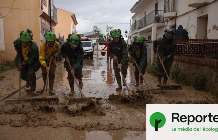
The violent floods which hit the Valencia region, in the south of Spain, on Tuesday October 29 and Wednesday October 30, caused at least 205 deaths and significant damage according to a still provisional report.
Urban planner specializing in bioclimatic design and adaptation to climate change, Clément Gaillard details for Reporterre the reasons which created the fertile ground for such a catastrophe.
Reporterre — It rained more than 400 mm of water in a few hours in places around Valencia, an amount that had not been observed since September 1996 (520 mm in 24 hours). During such extreme episodes, are floods inevitable? ?
Clément Gaillard — It is clearly documented that these exceptional rains will increase in frequency due to global warming. From this point of view, what falls on our heads is indeed an inevitability for which we will have to prepare.
But there is something that we control, it is the way in which we manage these extreme episodes, in terms of land use planning, town planning and soil treatment.
Valencia is located at the end of a gigantic watershed. It recovers all the water that was unable to infiltrate upstream. In the past, there were buffer zones on the outskirts of the city, but 9,000 hectares of Valencian orchards were destroyed between 1956 and 2011, or two thirds of their surface area, as demonstrated by the geographer Victor Soriano. It's almost the size of Paris. This urbanization, close to flood-prone areas, has increased vulnerability.
After the major floods of 1957, the municipality of Valencia diverted the Turia river, creating a new bed of 12 kilometers which bypasses the city from the south…
This is a typical approach to practices of the time. We have channeled watercourses, in large buried pipes or in the open air. Except that the life cycle of a river, in its natural state, is never completely regular. He moves into his major bed. Wanting to constrain him is a mistake.
On the contraryin Geneva, Switzerland, it was decided to do the opposite, with a renaturation of the waterways, particularly the Aire. The river will be diverted into an area where it can resume its natural course, without imposing a predefined shape or trajectory.
Is Spain a special case? ?
Areas urbanized in a somewhat anarchic manner, near flood zones or in major river beds, we find them all over the world. This corresponds to a time when urbanization took place without taking into consideration the issues linked to water. We treated rainwater as waste. We are paying for 150 years of brutal urbanization.
What should be done concretely ?
This is the whole question of town planning. There are two paths: if we have money, we can develop the land, the surfaces, the buildings. As much as possible, new development operations must take these subjects into account. And we have the possibility of changing what already exists. Some commercial areas are becoming deserted today. We can transform them to make them more porous and better adapted.
Since the 1970s, a counter-model has developed, with the « integrated rainwater management ». Unlike the desire to channel water, this method tries to ensure that the public spaces that we imagine can serve as a reservoir or buffer space to retain rainwater in the event of flooding. If we observe that a street turns into a torrent, we must design it in such a way that it can serve as a torrent in the event of an extreme episode.
« Review our arrangements and develop a new risk culture »
But if we don't have money, which is often the case, we must develop a culture of risk. Like in Japan where, from school, each citizen is trained in the reflexes to adopt in the event of an earthquake or tsunami. It's about learning to live with risk. Faced with the risk of flooding, this must lead us to review our occupation of the ground floors, ensuring that they are no longer inhabited in flood-prone areas. In Tours, for example, a collective of artists organized an operation « flood day »pretending there was a flood. People slept in a gymnasium, to mime the event and prepare for it.
It would be best to follow these two paths. Review our arrangements and develop a new risk culture. With climate change, we are going to experience volumes of precipitation that were never predicted.
With each new flood, it seems that our reflex is to strengthen the dikes: should we review this practice? ?
This can typically be a case of maladaptation: we consider solutions to the effects of climate change that only shift the problem. It is an important philosophical question to know whether we can adapt by avoiding, precisely, shifting the problem.
This precaution regarding dikes, however, depends on the area we are talking about: the Netherlands, for example, cannot exist without dikes, because many areas are below sea level. The important thing is that policies development plans integrate hydrological issues, which is generally the case during town planning operations in the Netherlands or Germany.
Is the city, in essence, unsuitable for climate change? ?
On the contrary, the proximity of facilities in the city makes it possible to reduce greenhouse gas emissions by limiting transport needs. Clustering into cities is a strategy humans have adopted for millennia to make things simpler. But if we densify our cities, we risk reducing the open land coefficient. That is to say the areas allowing water infiltration.
Cities should therefore be made to grow in height. But living in towers is less well accepted. We must therefore succeed in adapting this model as best as possible. This is the whole challenge of town planning: finding compromises between all the issues. We never have an ideal answer, but we must at least be able to design with knowledge of the facts.
legend


