By Arielle Bossuyt
Published on
May 6, 24 at 7:38 p.m.
See my news
Follow Le Démocrate Vernonnais
At the beginning of April, the level of the Seine increased significantly in Vernon (Eure) to the point that the floating docks on the left bank found themselves submerged for a few days. The previous week, a raw had been reported at the Yonne after heavy rain. A phenomenon which had the consequence of increasing the level of the Seine and the Marne.
A peak of 4.37 meters on April 7
Usually around the 3.7 meters in Vernon, from April 4, the level crossed the 4 meter mark until reaching a peak of 4.37 meters on April 7. For comparison, during the January 2018 flood, the level had exceeded the 5 meters. Data recorded using the graduated scale placed under the Clemenceau bridge.
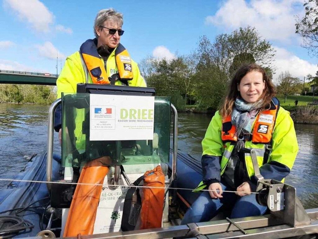
“It is not a question of the depth of the Seine, which varies greatly depending on the location, but of the water level on this graduated scale,” explains Christophe Dycke, employee of Drieat (Interdepartmental Regional Directorate of the environment, planning and transport).
Thursday April 18, he was on a mission to Vernon with Audrey Bildstein, head of the hydrology and measurement networks unit at Drieat. On board a boat, they were responsible for recording various data relating to the height and speed of flow of the river, in order to estimate the flow. On that day, the height of the Seine was 3.75 meters (according to the graduated scale, Editor’s note).
In the middle of the river, Drieat employees estimated a depth of around 7 meters. The flow fluctuated around 900 m3 per second.
As a reminder, the flow rate corresponds to the volume of water flowing in a given time. It varies naturally during the year and increases in the event of flooding since the flow will have a impact on the water height. During the 2016 flood, in Vernon, it was above 2,000 m3 per second.
Data visible in real time
In order to collect all this data and keep an eye on the river, Vernon has equipped itself with a monitoring station in 2006 connected to sensors in the Seine (the posts that we observe in the river, Editor’s note). These allow data to be transmitted in real time, visible on the Vigicrue website. (the figures are updated every ten minutes, Editor’s note).
Drieat employees come to the stations once a month to check the sensors and cross-reference the data.
“This allows us to see if there are any failures. We then rework the information collected on site and compare it so that it can be used, particularly in the context of forecasts. »
The Drieat of Île-de-France manages 80 stations distributed between the Seine, the Loiret, the Yonne, the Loing. The hydrology and measurement networks unit has 14 people. The work of the agents makes it possible to supply the Vigicrue site but also Hydroportail on which all the data is processed and archived.
The importance of locks in flood prevention
Near Vernon, two locks manage the level of the Seine: one located in Méricourt in Yvelines and the other in Notre-Dame-de-la-Garenne in Eure. “The dams help maintain a correct water level so that boats and barges can circulate, since we are on waterways. Without the locks, the levels would not be good,” explains Christophe Dycke, Drieat employee. Dams are levers for absorbing floods and regulating the water level: “They act like hydraulic elevators. In September, the water is released to be able to capture water in winter. » These infrastructures make it possible to intercept a significant flow, an element which was lacking during the flood of 1910 when the level of the Seine reached 7.11 meters in Vernon (see below). In Paris, the level had well exceeded 8 meters. The Great Lakes of the Seine in Troyes also play a role in water regulation.
“Our information can also be used by communities. Currently, the City of Paris (with a view to the Olympic Games and the freestyle swimming events in the Seine, Editor’s note) is particularly interested in the flow speed of the river because it plays a role in water pollution . »
In order to raise public awareness of the work of Drieat, an educational panel will soon be installed under the Clemenceau bridge presenting a QR code leading to the Hydroportail site.
Follow all the news from your favorite cities and media by subscribing to Mon -.


