This and the strong winds have led to dangerous and unpredictable driving conditions, especially as rising daytime temperatures bring rain rather than snow, particularly in the west, only for it to get colder again in the evening.
Some calm weather temporarily settled over the mainland overnight, thanks to a departing high-pressure ridge. However, snow clouds, driven by a low-pressure system moving from southern Scandinavia across the Gulf of Finland, were forecast to reach the islands before midnight, with heavy snowfall and blizzards spreading quickly across the mainland early in the morning.
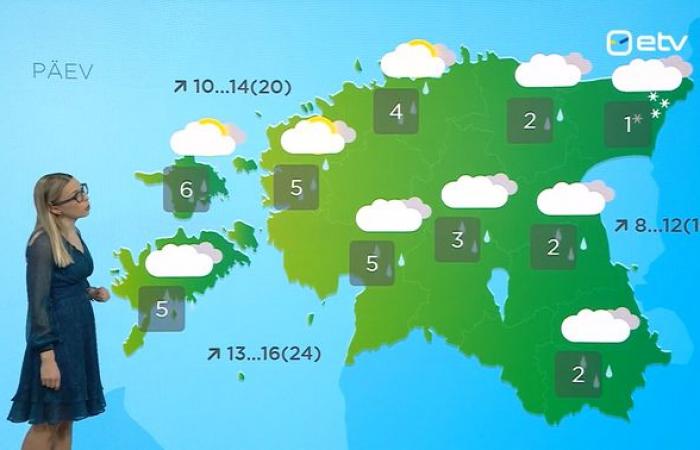
Temperatures will rise as the morning progresses, up to +5 degrees Celsius over the islands and +1–2 degrees in the west and south, though it will be colder in Tallinn and the north coast (-2 degrees).
This is being accompanied by strong winds, southerlies of 9–15 meters per second in gusts up to 22 meters per second, driving snow and sleet before it – save for in the mildest parts over the islands and the westernmost areas of the mainland, where the precipitation is falling as rain.
As the day progresses, the low-pressure system is to move eastward over southern Finland and the Gulf of Finland.
This means rain and sleet will continue to fall widely, though the snow will persist in northeastern Estonia through the morning and into the daytime.
Temperatures in the western half of the country will be milder during the daytime, at +4 to +6 degrees, than in the center and east, at +1 to +3 degrees.
The strong southwesterlies will remain, with coastal gusts up to 24 meters per second.
It will remain wholly overcast save for the northwest coast and, again, the islands, where the sun will occasionally peep through.
The winds will gradually weaken by the evening, swinging round to the north.
However, as a new cold air mass moves in, precipitation will shift back to snow, starting in the northwest.

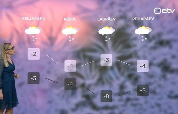
In the first few days of 2025, it will stay cold, however. Mean air temperatures will be below zero every day, though no lower than -4 on average, and at night too – with the coldest values forecast for Friday night, at -8 degrees.
The Transport Administration has already issued a warning urging drivers to exercise caution due to the icy and hazardous road conditions throughout the region.
At least the days are starting to get longer, albeit at a very slow rate for now: Sunrise is at a bit before 9:20 a.m. on New Year’s Day, compared with around 9:15 a.m. on Sunday, while sunset, just after 3:30 p.m. on Wednesday, comes nearer to 3:40 p.m. on Sunday.
—
Follow ERR News on Facebook and Twitter and never miss an update!
Source:
“Actual camera,” weather forecaster Kirsi Kajamäe-Novikov.


