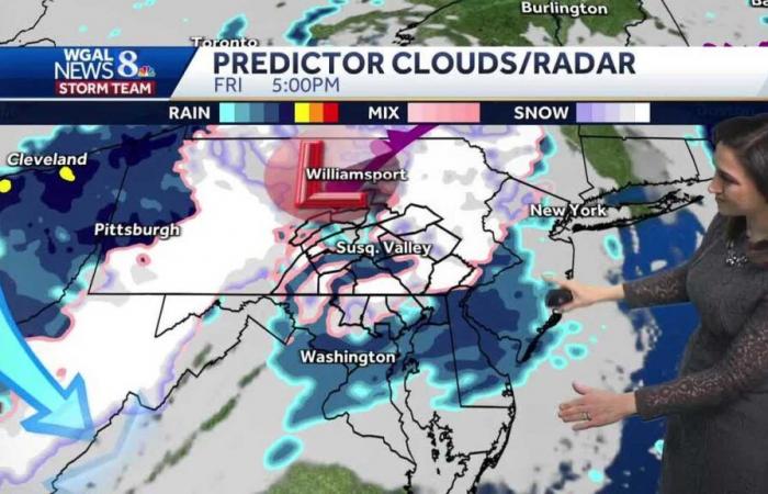
OFF TO OUR NORTHEAST. THIS AREA OF LOW PRESSURE OVER THE GREAT LAKES IS STARTING TO DIE OFF, BUT IT’S GOING TO KICK A LOT OF COLD AIR OUR WAY TO GENERATE THAT SNOW. AS WE HEAD INTO TOMORROW. SO HERE’S WHAT THE PREDICTOR SHOWS. TODAY WE START OUT WITH A SUN. THEN WE SEE INCREASING CLOUDS AND A COUPLE OF SHOWERS IN THE AFTERNOON AND EVENING. TONIGHT THERE COULD BE SOME PARTIAL CLEARING, BUT NOT FOR LONG. BY TOMORROW MORNING, CLOUDS FILL BACK IN AND SOME LIGHT SNOW DEVELOPS FROM NORTH TO SOUTH THROUGH THE MORNING HOURS. ROADS WILL BE WET AND THEN IN THE AFTERNOON THOSE SNOWFLAKES MIX WITH RAIN WILL BE UP TO ABOUT 40 FOR OUR HIGH TEMPERATURE. ALL OF THAT RAIN HITS THE ROAD LATE ON FRIDAY NIGHT AND THEN SATURDAY IS LOOKING MAINLY DRY. CAN’T RULE OUT A COUPLE OF TRAILING SHOWERS. I DO SEE CLOUDS HANGING TOUGH ON SATURDAY THOUGH, WITH HIGHS CLOSE TO 50, SO PREDICTOR ESTIMATED SNOWFALL TOTALS. YOU SEE AT ELEVATION YOU’RE GOING TO DO BETTER. I FAVOR AREAS, ESPECIALLY OUT TO OUR WEST NEAR JOHNSTOWN AND SOMERSET FOR SOME HIGHER TOTALS. EVEN IN PARTS OF NORTHERN LEBANON, DAUPHIN AND SCHUYLKILL COUNTIES ABOVE 1500 FEET, YOU COULD PICK UP AN INCH OR TWO AT ELEVATION. SO HERE’S A LOOK AT OUR TEN DAY FORECAST. WE HAVE 48 DEGREES FOR THE HIGH TODAY, 40 TOMORROW. COOLEST DAY OF THE WEEK. WE’RE UP TO 50 ON SATURDAY, 52 FOR SUNDAY AND NEXT WEEK WE START IN THE 50S BUT END UP IN THE 40S WITH A SYSTE
Hour-by-hour snow projections for South-Central Pa.
Updated: 8:14 AM EST Nov 21, 2024
The first snow of the season in South-Central Pennsylvania is expected to arrive Friday morning.Above, we’ve posted the hour-by-hour model run, showing snowfall projections for the Susquehanna Valley.The WGAL News 8 Storm Team has designated Friday as an Impact Day, meaning the weather could disrupt your normal daily schedule or routine.WGAL NEWS 8 STORM TEAM | The full forecast is here.Winter weather toolkitWe put together this Winter Weather Toolkit to highlight all of the weather features right at your fingertips at WGAL.com and on the WGAL app – iPhone | Google Play.Stay weather awareRADAR: Track wintry weather with WGAL’s interactive radar.CLOSINGS: See if schools, businesses, churches or other organizations are closing or delaying.LOCATION-BASED ALERTS: Instructions for activating our personalized weather alerts are here.ROAD CLOSURES: Our interactive traffic map is always updated with crashes, construction and road closures. It even has a weather radar overlay.EMAIL ALERTS: We’ll send you daily updates, or just alerts when snow, sleet or ice are headed your way.HOUR-BY-HOUR: See what you can expect every day with the hourly forecast.WEEKEND WEATHER: Know what to expect before you make your plans.10-DAY FORECAST: Check WGAL’s extended forecast here.Alert Days vs Impact DaysYou may hear the WGAL News 8 Storm Team highlight Alert or Impact days in the forecasts. Here’s what that means:An Impact Day is a day that features weather that will likely disrupt your normal daily schedule or routine.An Alert Day is a day that features the threat of extreme, severe, and possibly life-threatening weather.Share your weather photos and videosWe have several ways you can show us your snow photos and videos. We may use them on air or online.Here’s how you can share:DIRECT UPLOAD: There is a form here to let you upload photos or video.EMAIL: Just send to [email protected].
The first snow of the season in South-Central Pennsylvania is expected to arrive Friday morning.
Above, we’ve posted the hour-by-hour model run, showing snowfall projections for the Susquehanna Valley.
The WGAL News 8 Storm Team has designated Friday as an Impact Daymeaning the weather could disrupt your normal daily schedule or routine.
WGAL NEWS 8 STORM TEAM | The full forecast is here.
We put together this Winter Weather Toolkit to highlight all of the weather features right at your fingertips at WGAL.com and on the WGAL app – iPhone | Google Play.
Stay weather aware
Alert Days vs Impact Days
You may hear the WGAL News 8 Storm Team highlight Alert or Impact days in the forecasts. Here’s what that means:
- An Impact Day is a day that features weather that will likely disrupt your normal daily schedule or routine.
- An Alert Day is a day that features the threat of extreme, severe, and possibly life-threatening weather.
Share your weather photos and videos
We have several ways you can show us your snow photos and videos. We may use them on air or online.
Here’s how you can share:
Belgium


