The strongest storm in years is about to hit parts of Western Washington, according to University of Washington Atmospheric Sciences professor Cliff Mass.
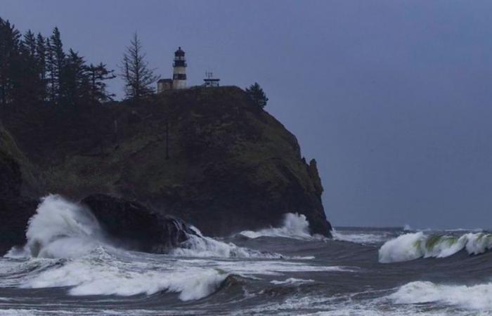
Mass told KIRO Newsradio that a cyclone developing in the Pacific Ocean is the equivalent of a Category 1 hurricane.
“It will be as strong as a hurricane in terms of wind speed and size,” he explained.
However, because this storm develops differently and has a different energy source, it is called a “cyclone” instead.
“They’re just as intense, but we don’t call them hurricanes,” Mass said.
More weather: King tide season has arrived in Western WA
Mass expects strong winds along the Washington coast and Vancouver Island on Tuesday, with gusts up to 60-80 mph. Downed trees and power outages are likely, he said.
“There may be a significant impact here in Western Washington because this very deep low offshore will create a large difference in pressure across the Cascades,” he warned.
The hardest-hit areas will be the Cascade foothills.
“Places like Enumclaw, Black Diamond and North Bend are going to get some extremely strong winds. Some of those winds may extend out even as far as Sea-Tac Airport. It’s going to get very windy on Tuesday afternoon and evening,” Mass said, expecting gusts of 60-80 mph.
Mass notes that such weather events are rare.
“We do get lows off the coast, but this is going to be an extraordinary one. This is going to be one of the strongest in probably a decade or so offshore. It’s revving up very quickly, unusually so. It’s happened before, but this is an unusual event,” he explained.
For downslope wind storms, he added, “We get strong winds here every three to five years, a really strong one every 10 or 20. This one is potentially on the strong side, but we’ll have to watch it.”
Mass advises residents to prepare now.
“There’s an extremely good chance of power outages along the coast and the foothills on the western side of the Washington Cascades. If you live there, you should be ready for a power outage,” he said.
For those living closer to Puget Sound, the impact won’t be as severe.
“If you get away from the mountains, it’ll be blustery. The winds will probably gust up to 20-40 mph, but it’s not going to be the damaging kind of winds that we’re going to see in the foothills or the coast,” Mass said.
The upcoming storm is not just a typical weather event but an extraordinary one that has been building up rapidly.
“This is going to be one of the strongest in probably a decade or so offshore. It’s revving up very quickly, unusually so,” Mass emphasized.
The combination of the cyclone and the downslope wind storm makes this a significant event for the region.
Residents in the affected areas are urged to take precautions.
“If you live there, you should be ready for a power outage. This is a good chance,” Mass advised.
Preparing for potential power outages and securing outdoor items that could be blown away by strong winds are essential steps to take.
Similar news: Wind advisory ends after gusts reached 50 mph in Western WA
The storm is expected to bring hurricane-strength winds to the Washington coast and Vancouver Island, with significant impacts in the Cascade foothills. While the Puget Sound lowlands will experience blustery conditions, the most severe weather will be in the foothills and coastal areas.
With the storm’s rapid development and potential for strong winds and power outages, residents are encouraged to prepare now for what could be one of the most powerful storms in recent years.
Interview transcript:
Charlie Harger: Cliff, thank you for joining us today. We don’t call these hurricanes, but am I right that this is what is called a bomb cyclone?
Cliff Mass: It is. In fact, it will be as strong as a hurricane in terms of wind speed and size. The only reason we don’t call it a hurricane is because its origins are different. Hurricanes develop over warm water, which gives them their energy. Our storms get their energy from a different source, the change in temperature north-south. So, they’re low-pressure systems, they’re cyclones. They’re just as intense, but we don’t call them hurricanes.
Charlie Harger: But if it walks like a duck and talks like a duck, it’s something there and it’s going to cause at least a lot of wind and rain. Where is it going to be affected by this? Is it the Washington coast, the BC coast? What are you expecting?
Cliff Mass: Well, there are several effects. There will be very strong winds along the coast. Some places along the Washington coast and particularly the coast of Vancouver Island can have winds gusting up to 60 to 80 mph. Interestingly enough, there may be a significant impact here in Western Washington because this very deep low offshore will create a large difference in pressure across the Cascades. We’re going to get winds accelerating as they go from east to west down into Western Washington. So, I expect downslope winds in the foothills, so places like Enumclaw, Black Diamond, or North Bend are going to get some extremely strong winds. Some of those winds may extend out even as far as SeaTac Airport. It’s going to get very windy on Tuesday afternoon and evening.
Charlie Harger: You usually don’t use words like “extremely strong.” Can you give us an idea of how strong this might be?
Cliff Mass: In those areas, we could have gusts up to 60 to 80 mph. There could be power outages. This is something we get once in a while, the cold downslope wind storms. Enumclaw is very famous for it, and it looks like we will have one of those again on Tuesday.
Charlie Harger: And this is a direct result of the cyclone on the coast?
Cliff Mass: That’s right. It’s created by this kind of phenomenon, a big difference in pressure across the Cascades with an intense low offshore.
Charlie Harger: How often does this sort of thing happen? And by that, I guess that would be two questions because of the cyclone in the Pacific and also these downslope wind storms.
Cliff Mass: We do get lows off the coast, but this is going to be an extraordinary one. This is going to be one of the strongest in probably a decade or so offshore. It’s revving up very quickly, unusually so. It’s happened before, but this is an unusual event. For downslope wind storms, we get strong winds here every three to five years, a really strong one every 10 or 20. This one is potentially on the strong side, but we’ll have to watch it.
Charlie Harger: OK, so this will be almost an hour-by-hour situation?
Cliff Mass: Yeah. The models are very good, and especially as we get into Tuesday morning, we should know what will happen.
Charlie Harger: So, your word of advice might be to start preparing now, especially if you’re in the foothills or any of the areas you’ve mentioned. Maybe start prepping for potential power outages?
Cliff Mass: That’s right. There’s an extremely good chance of power outages along the coast and the foothills on the western side of the Washington Cascades. If you live there, you should be ready for a power outage. This is a good chance.
Charlie Harger: Let’s look from, say, Olympia to Everett. How is it looking along the Puget Sound lowlands?
Cliff Mass: If you get away from the mountains, it’ll be blustery. The winds will probably gust up to 20 to 40 mph, but it’s not going to be the damaging kind of winds that we’re going to see in the foothills or the coast.
Charlie Harger: OK. And just real briefly, how are we looking for the winter season overall? I hear there are some models that say it might get kind of cold.
Cliff Mass: We are in a La Niña period, which means the tropical Pacific is colder than normal. That tends to have a correlation with our weather here. In La Niña years, we tend to be cooler than normal, slightly wetter than normal, with more snow in the mountains. This is not the strongest La Niña in the world, but we tend towards that direction.
Charlie Harger: What’s it like at your weather station, your forecasting center, when you see something like this developing? Do you take a double glance? What goes through your mind when you see that?
Cliff Mass: We have our little conversations online between meteorologists, and of course, people are very excited about this. There’s a lot of traffic online about it right now. We love weather. Most meteorologists love weather, and we particularly like extreme weather.
Charlie Harger: Well, let’s hope it is one of those storms that is exciting but doesn’t cause much damage, and we can all go, “Wow, that was crazy.”
Cliff Mass: I have to be honest. If you’re on the coast or in Enumclaw, it’s going to be crazy. So be ready.
Charlie Harger: Alright, Cliff Mass. Thanks for your time today.
Charlie Harger is the news director for MyNorthwest and KIRO Newsradio. Follow Charlie on X here and email him here.


