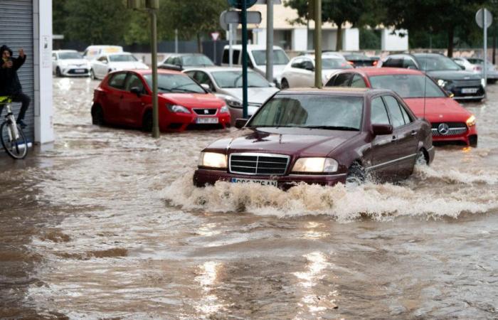
The significant risk of rain puts various areas of the country on notice. Almeria, Catalonia, Murcia and the Valencian Communityaccording to the State Meteorological Agency (Aemet).
Specifically, it has extended the red notice, of extreme danger, to the entire province of Almeríaexcept for the west and capital — which are under a yellow warning — due to torrential rains and possible overflowing of riverbeds and flooding. “The danger is extreme! Do not travel unless it is strictly necessary!” Aemet has indicated on social networks. This call has been joined by the president of the Junta de Andalucía, Juanma Moreno, who has asked for “maximum caution.”
The notice has been established, in principle, between 9:00 a.m. and 5:59 p.m. in part of the province of Almería due to “extreme risk due to rain”, specifically in the Levante area, Valle del Almanzora and Los Vélez, and Nacimiento and Campo de Tabernas, where it is expected a total of 60 liters per square meter in an hour.
In addition, 110-120 liters can be reached in twelve hourswith the possibility of reaching higher totals in some points. As announced by the Board through Emergencies 112, the Emergency Plan, operational situation 1, has been activated in the north and east of Almería due to the risk of flooding.
In other areas of the Mediterranean, the agency continues, “the orange warning persists: significant danger.” In this way, it is expected that the accumulated precipitation could reach 100 liters per square meter in twelve hours. on the southern and northern coasts of Valencia; northern coast and northern interior of Castellón; and southern prelittoral and southern coastline of Tarragona and in Vega del Segura, Murcia.
At all these points the showers will be localized, so that nearby locations could have very different accumulations. The yellow warning – of lower intensity – is also established in the rest of the Valencian Community due to precipitation accompanied by hail that could accumulate 20 liters per square meter in one hour and 60 l/m2 in twelve hours.
Special notice due to the impact of rain on accumulated water
Both in the areas of Catalonia and the Valencian Community, the most affected by DANA, with more than 200 fatalities, The warning begins at 9:00 a.m. (until that time the alert is yellow)while in the Region of Murcia is already activated. In the Guadalentín Valley, Lorca, Águilas, Campo de Cartagena and Mazarrón, all of them in Murcia, between 40 and 50 liters per square meter are expected to be collected in one hour. The forecast is that the alerts will remain throughout the day.
It should be noted that the Emergency Coordination Center of the Generalitat has issued a special warning due to the impact that rainfall may haveif it occurs, due to the rain accumulated on the ground.
In Catalonia, in addition to Tarragona on orange alert, areas of Barcelona and Girona are also on alert, but at yellow level. For example, on the southern and pre-coastal coasts of Girona and Barcelona are expected to accumulate 20 liters of precipitation in one hour. per square meter.
Yellow notices in points of Andalusia and Aragon
In the Andalusian community there are also yellow warnings for coastal phenomena on the Cádiz coast, the Strait, the Granada and western coasts and Almería capital. East wind is expected between 50 and 61 kilometers per hour.
In Aragon, yellow level alerts will also be activatedboth due to rain and storms – both of low probability -, specifically points of Teruel (Bajo Aragón). The accumulated precipitation in one hour could be 20 liters per square meter. Also areas of Castilla-La Mancha are; Hellín and Almansa, both due to rain (accumulation in one hour of 15 liters per square meter) and storms with probable hail.
For this Monday The yellow notice will be maintained in the province of Castellón due to rainfall of 20 liters per square meter in one hour and 60 l/m2 in twelve hours.
Rising temperatures
Las Maximum temperatures increase in the Canary IslandsCantabrian coast, Iberian and Catalonia, and descend in the north of Castilla y León and the upper Ebro. Increasing lows in the northeast and eastdeclining in the center and few changes in the rest.
East winds will predominate in the peninsula and the Balearic Islands, with east and south winds in the Cantabrian Sea, northwest and the Gulf of Cádiz. In general they will be weak inland and more intense on the coast, with strong intervals and very strong gusts in the Strait and Alborán; In the Canary Islands, light winds will blow from the east in the eastern islands and, more intense, from the southwest, rolling to the northwest in the western islands.
*Follow the latest news about the weather and weather forecast on RTVE.es


