By
Briac Trébert
Published on
June 18, 2024 at 6:47 a.m.
See my news
Follow News
They were announced, they will multiply this week. A new round of storms will hit a large part of France this Tuesday June 18, 2024. A sequence which could be marked, with possible associated violent phenomena.
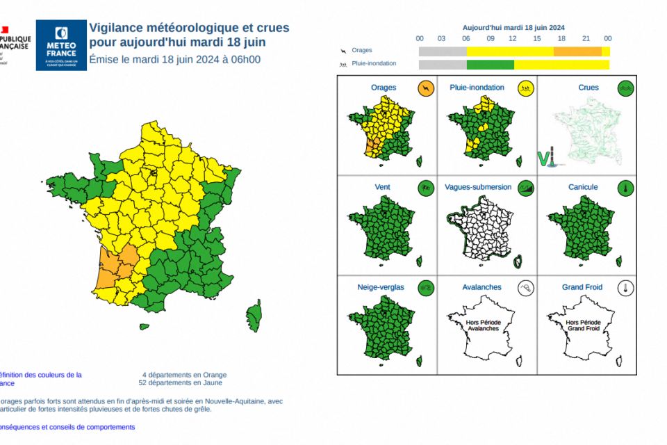
In its 6 a.m. bulletin this Tuesday, Météo France has already placed four departments on orange alert (Dordogne, Gironde, Landes and Lot-et-Garonne). Vigilance begins at the end of the day, at 6 p.m.
52 departments are also in yellow, from the Pyrenees to Pas-de-Calais, because of these upcoming bad weather.
The storm system expected this Tuesday evening over New Aquitaine will circulate quickly towards the west and north of the Massif Central as well as towards Center-Val-de-Loire then Burgundy. An extension of orange vigilance to other departments remains possible.
Strong squalls, intense rain and large hail
These storms could be violent with strong gusts of wind, intense rain “and above all a risk of large hail”, warns the weather organization. They are expected late afternoon and early evening this Tuesday in New Aquitaine and should then spread towards the Center and Burgundy.
This stormy degradation should take place on the Bay of Biscay then approach the west of New Aquitaine initially then the north of New Aquitaine before evacuating towards the north of Massif Central and Centre-Val-de-Loire during the night.
As the storm system passes, we are waiting in the departments placed on orange vigilance for hail (marked risk of hailstones with a diameter greater than 2 cm), cumulative rainfall of up to 30 to 50 millimeters in a short time and wind gusts of around 90 to 100 km/h.
Note that a first stormy salvo, less violent however, should already affect the regions from Normandy to Center-Val-de-Loire this Tuesday morning with, in places, hail possible.
Follow all the news from your favorite cities and media by subscribing to Mon Actu.


