Highlights of this Monday
– thunderstorms from the Pyrenees to the Jura to Alsace with a risk of hail at the end of the day
– significant degradation in the south hence our alert and strengthening of the rains in the evening with a Cévennes episode
This morning
Threatening weather awaits you with rain and stormy showers already in the southwest as well as in Languedoc. North of the Loire, the weather is calmer, but very cloudy, except near the English Channel where clearings are required. The mildness is present from daybreak with 12 to 20°C from Alsace to Provence.
This afternoon
North of the Seine, as well as in the Pyrenean foothills, you are privileged with generally dry and mild weather despite a thick veil of clouds. From Vendée to Brittany, to Pays de la Loire to the interior of Normandy, showers are developing. It is from the south of the Massif Central to the Center-East that the deterioration is most marked with showers and stormy rains which are increasing. Around the Mediterranean too, the weather is getting worse.
It is mild with 19 to 24°C from north to south.
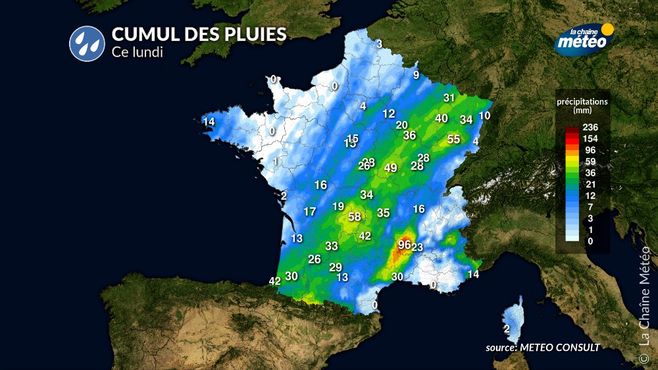
Total rainfall Monday October 7 © the weather channel
Evening and night from Monday to Tuesday
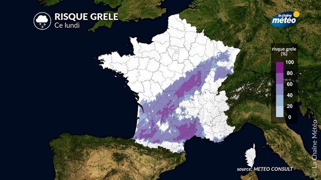
Be careful, because the rains increase in the southwest as far as Burgundy in the evening with a risk of hail.
Risk of hail Monday October 7 © the weather channel
These grigenous storms will extend to Languedoc. They will go back towards Auvergne-Rhône-Alpes and Franche-Comté during the night from Monday to Tuesday. A Cévennes episode takes hold in Ardèche.
Things to remember over the next few days: conditions are very choppy on Tuesdayi in the south and east with intense rains. On Wednesday, if the weather begins to improve in the south, it is in the north that conditions become agitated in connection with the rise in temperature. Ex-Hurricane Kirk with a risk of storms between Wednesday afternoon and Thursday morning.