


This weekend will be marked by the passage of two new depressions of oceanic origin near our regions, the first passing on Saturday from Brittany towards the North Sea, the second lingering on Sunday and Monday on the Channel before sliding towards northern Italy.
videos
The sky will therefore become cloudy this Saturday from the west and south of the country and rain will sprinkle all the provinces around midday with even a risk of storms in Limburg and the province of Liège. The maximum temperatures will be reached before the arrival of bad weather with around 12° in the upper Ardennes, 14° on the coast and 15 to 17° elsewhere. The south to southeast wind will not be too strong, blowing at peaks of 30-50 km/h.
Other improvements will appear at the end of the day from the French border. It will continue to be cool with roughly the same daytime temperatures as the day before.
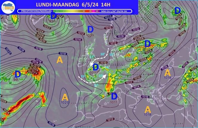
Mondaythe proximity of the second depression will increase the instability of the air mass under a very changeable sky with, from the morning, showers over the west and south of the country and even thunderstorms sometimes accompanied by hail and Gusty winds in the afternoon and evening in many places.
It will be a little cooler with locally 18° in the plains.
Tuesdayan anticyclonic zone will develop from the west of the British Isles to the south of Scandinavia which will put us in a flow oriented north-east towards the south-west where freshness and rain or showers will still circulate which will however decrease by intensity moving away towards the south and being followed in the afternoon by beautiful clearings in the north and west of the country
Wednesdaythe cool current from north to northeast will still persist over the country with morning temperatures between 6 and 11° and afternoon maximums of barely 11 to 15° in the Ardennes and 15 to 18° in the plains .
The sky will initially still be very variable with the last showers in the eastern provinces but also clearings then spreading from the west of the country.
No improvement before the second half of next week
THURSDAYAscension Day, the anticyclonic center will have moved towards the south of the North Sea which will favor dry weather with increasingly beautiful clearings and a small increase in maximums which will be between 13 and 17° on the Ardennes and between 17 and 20 in the plains.
Friday and Saturdayas the anticyclone will slowly move towards central Europe and the north of the Balkans, it will organize over western Europe an increasingly gentle and above all very dry continental current with lots of sunshine and maximums rising between 16° in the Hautes Fagnes and generally 21 to 23° in the plains and at the sea.
Probable developments for Sunday May 12
It should still be very mild or even quite hot with daytime temperatures between 17 and 24° but the risk of showers will increase in the evening or the following night.


