


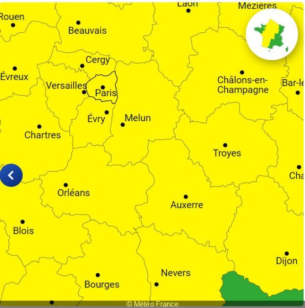


The weather is still very unstable and a risk of thunderstorms is once again announced over part of France on June 18, 2024. Météo France places around fifty departments on yellow alert for thunderstorms this Tuesday. Paris and the 7 other departments of Île-de-France are affected by this alert. We take stock of the forecasts.
Will thunder rumble this Tuesday, June 18, 2024 at Paris and Île-de-France ? It’s possible. New storms could hit part of the country at the start of the week. Also, Meteo France places around fifty departments of France in yellow alert for thunderstorms for this day of June 18.
In detail, a large part of France, going from the southwest to the north, is placed on yellow alert.thunderstorms“. The Pyrénées-Atlantiques, Lot-et-Garonne, Gironde, Charente-Maritime, Seine-Maritime, Pas-de-Calais, Ardennes, Puy-de-Dôme or even the Meuse and the Oise have thus placed in yellow vigilance for a risk of violent thunderstorms this Tuesday. “Risk of strong thunderstorms over the country in several waves, from the end of the night from Monday to Tuesday, until the evening of Tuesday“warns Meteo Franceadding that “heavy rain and hail are to be expected“.
“This day presents a very strong conflict of air masses over France with a burst of very strong heat in the east. Result: violent thunderstorms are expected from the southwest to the northeast” announces La Chaîne Météo on its site.
What about the weather Paris and the Île-de-France region ? The capital and the 7 other Ile-de-France departments (Seine-et-Marne, Yvelines, Essonne, Hauts-de-Seine, Seine-Saint-Denis, Val-de-Marne and Val-d’Oise) are also placed by Météo France in yellow alert for thunderstorms this June 18. Météo France thus announces a “Active rain-stormy passage expected early in the morning with locally marked rainy intensities (even a little hail in places)“, followed by a “lull during the day then more uncertainty about the potential risk of storms at the end of the day and evening“.
So, according to Meteo Francestorms could hit all departments of Île-de-France this Tuesday morning between 6 a.m. and 11 a.m., then again at the end of the day, between 5 p.m. and midnight.
Residents and visitors to the region are advised to remain vigilant, follow Météo France updates and take necessary precautions to protect themselves from these severe weather conditions.
Recommendations for Ile-de-France residents
During these periods of bad weather, Meteo France recommends paying attention to thunderstorms, which are synonymous with danger. here are some recommendations to follow as a precaution:
- limit your movements,
- do not go out with an umbrella,
- take shelter under a building,
- avoid touching electrical wires on the ground,
- move away from posts, gates, trees and watercourses,
- by car, avoid wooded areas.


