A remarkable Cevennes episode is in place until Friday. Follow the situation in real time with our tracking article.
This Thursday
A 7 h 29the stormy rains continue to reactivate constantly on the Cévennes relief. The structure of these storms is reminiscent of a “V” shape, typical of these self-regenerating convective structures.
At 6:59 a.mthe rains are abundant on the Cévennes relief, but also reach all of Lyon up to the Saône valley. The intensities on the Cévennes relief sometimes reach 30 to 40 mm/h, with total accumulations revised upwards, while waiting for the peak of intensity for this afternoon.
A 6 h 02the rains were heavy all night in the Cévennes where the accumulations exceeded 400 mm in 24 hours locally. Since the start of the episode, 500 mm have already been reached in Mayres (07) for example.
This Wednesday
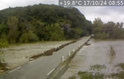
At 9 p.mthe rains remain intense in the Cévennes. In the south of Lozère and central Ardèche, the equivalent of 1 month of rain has already fallen. The Ardèche upstream, the Baume, the Chassezac, the Cèze, the roaches of Alès and Anduze undergo significant reactions and enter into flood. Furthermore, rains coming from Spain invade the west of the Pyrenees, taking on a stormy character.
The situation continues to deteriorate throughout the night from Wednesday to Thursday in the areas mentioned. Avoid traveling as much as possible. The greatest caution is also recommended if you find yourself near rivers flowing down from the Cévennes swollen by rainwater.
At 7:20 p.mthe Cévennes episode continues. The bar of 300 mm of rain in 24 hours has just been reached in Villefort in Lozère. Stormy showers are developing in the east of the Var, in the Fréjus sector. Other stormy showers occur in Roussillon, remaining scattered for the moment.
At 6:25 p.mif conditions improve in Provence Côte d’Azur and the plains of Languedoc, the Cévennes episode is in full swing on the relief of the south of the Massif Central. Accumulations are approaching 300 mm in the Villefort sector (48), corresponding to 1 month of rain.
At 5:42 p.mthe total rain reached 273 mm in Villefort (48), although we are not yet halfway through the episode.
Generally, the Cévennes heights range from 200 to 250 mm. In the PACA region, a few stormy showers persist in the hinterlands, but without the intensity of this morning.
To the west, the new disturbance brought sometimes sustained rain to the Pays de la Loire and Limousin.
At 4:11 p.mit is still raining in the Cévennes, but the rain remains moderate only in the high relief. The new oceanic rains are arriving in the Nantes region with moderate intensities.
At 2:53 p.mheavy stormy rains continue on the summit of the Cévennes. It has fallen in the last 24 hours, 220 mm in Villefort (Lozère), 200 mm in Cassagnas (Lozère), 196 mm in Mayres (Ardèche) and even 130 mm in Colognac in Gard. Rivers respond quickly.