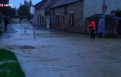

A 16hthe Vigicrues organization places the Seine-et-Marne department on red level alert for the Grand Morin flood which promises to be exceptional. Only 15 days after the last flood at the end of September, the precipitation expected until next night, the equivalent of a month of rain, will cause a major flood peak next night with flooding in the valley of Grand Morin.
A 15h13the rainfall totals are becoming exceptional in the Loire" rel="tag">Pays de la Loire with 95 mm observed in the last 24 hours. The rain record of 96.3 mm dating from 1946 is about to be broken. We also noted 70 mm in Nantes (44) and 82 mm in Pornic (44). The wind blows in stormy gusts on the Basque coast with 120 km/h in Ciboure (64). On the Pyrenees relief, we find 116 km/h at Loudervieille in the Hautes-Pyrénées. The southerly wind strengthens significantly in the center-east with 109 km/h in Brindas (Rhône), 104 km/h in Puy-en-Velay, 96 km/h in Lyon.
At 2 p.m.it still rains continuously on the Pays axis from the Loire to the Ardennes via the Paris basin. The rainy axis will strengthen during the afternoon.
At 12:30 p.m.the very rainy axis extends from the Pays de la Loire to the Benelux. The intensities are more marked between Nantes and Le Mans. We are already seeing up to 1 or 2 weeks of rain in places.
Storm Kirk © The Weather Channel
At 12 o’clocka gust of 211 km/h was recorded at Iraty (1427 meters) in the Pyrénées-Atlantiques. On the Aquitaine coast, the first strong gusts are also observed with 93 km/h at Pointe de Socoa (Pyrénées-Atlantiques). In the center-east, the southerly wind is also strengthening with 85 km/h in Les Sauvages in the Rhône.
Storm Kirk © The Weather Channel