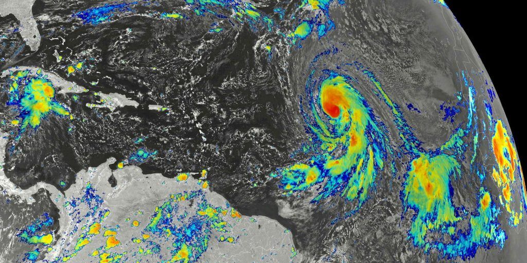
Abe careful, be careful! This week, France is under the influence of not one but two ancient tropical systems, as mentioned The Parisian. Tropical storm Joyce as well as hurricane Kirk could thus hit France. But it will only be remnants of these two tropical systems. So high in the northern hemisphere, the daily specifies, they lose their tropical characteristics and are therefore less violent than they may have been in the past.
Every Saturday at 4 p.m.
Receive all the latest science and tech news and dive into major talks, major discoveries, innovations and behind the scenes…
Merci !
Your registration has been taken into account with the email address:
To discover all our other newsletters, go here: MyAccount
By registering, you accept the general conditions of use and our confidentiality policy.
Joyce, this former tropical storm turned depression, will be the first to hit the country at the end of this weekend. Off the coast of Ireland, its size and counterclockwise rotation will cause an upwelling from southern Europe as well as northern Africa. We could therefore reach 25°C in the south-west of France. It is not excluded that, locally, temperatures will be even higher. But Joyce will not only cause a rise in temperatures.
ALSO READ 15 dead, thousands affected: storm Boris devastates central EuropeHeavy rainfall will indeed hit the entire country on Monday. First in the North-West, due to the depression. But, with the air mass, they will also move in the South, with particularly high intensities between the Cévennes and the south of the Jura. After this Joyce episode, which is likely to be particularly significant, it will be the turn of the remains of Hurricane Kirk to intervene, during the night from Tuesday to Wednesday.
Gusts between 90 and 100 km/h
For the moment, it is expected that it will lose its tropical characteristics and affect France while it will be at the storm stage. The NHC, the American hurricane center (a country recently hit by Hurricane Helene), warns, however, that it is difficult to accurately predict its trajectory more than three days apart. But the trend still remains that the heart of this storm will indeed hit the country and will not just follow it in the Channel, as was initially predicted.
Indeed, the forecasts are, as the days go by, less and less good. The quantities of rain expected in the territory are always higher, the wind speed is increasing and the extent of the areas concerned is increasing. If we imagine an axis starting from Nouvelle-Aquitaine and going to the borders of the north-east of the country, the remains of this hurricane Kirk could cause gusts of between 90 and 100 km/h.
ALSO READ Rain and storms: Guadeloupe placed on red alert by Météo-FranceSo between the winds of a depression and those of a storm. But The Parisian believes that this speed, in certain regions with little exposure and where the trees, with their leaves, are still very heavy, could not be without consequences. Central Europe knows something about this, having been hit in September by the historic storm Boris.