Over 1500 kilometers, almost half. And much more than what he expected.
“When we look at certain great rivers of the world, like the Rhône, it is obvious that they are very anthropized because we see that the banks have been worked. But it is not easy when you look at the banks of the St. Lawrence, with trees and vegetation, it gives the impression that it is still relatively natural. Except that when we did the exercise, we realized that there were about one kilometer of banks in two which was artificial. For us, it’s still huge, “said Mr. Mériy, who is a research professional at the researcher’s laboratory Patrick Lajeunesse, a geomorphology teacher at Laval University.
Mr. Mériy presented these results Wednesday morning at the 92nd ACFAS congress, which is held this week in Montreal.
“Zero time”
Between 2017 and 2020, Mr. Mériery and the rest of the team have mapped all the banks of the St. Lawrence in several ways between Cornwall and the east tip of the island of Orleans with a resolution of five meters. Their goal was to establish a “zero time” in order to measure later how storms, floods and ice change the contours of the river.
But the researchers quickly realized that their initial question was not very relevant everywhere: if it is the human who is the main “factor” which reshapes the banks on the half of the sector studied, then measuring natural factors which have much less impact does not have so much meaning – even if natural disasters can have enormous impacts on residents, but that is another question.
“It is sure that if we look at the daily changes in the coastline, we can see a correlation between the traits of the coast and the big storms or the ice. But in the longer term, we no longer see this correlation [dans la moitié du Saint-Laurent dont les berges sont artificielles]”Explains Mr. Mériy.
Between Cornwall and Trois-Rivières, 50 % of the banks were reshaped in one way or another by human action. Between Trois-Rivières and the Pointe d’Argentenay, it is a little less (40 %), but the total still remains at 48 % over the entire length studied.
-If the “human hand” sometimes looks at the eyes, it is much less obvious in places that ended up turning up afterwards. This is particularly the case for several river beaches in Quebec. That of the Anse-Tibbits in Lévis, for example, does not appear on the cards drawn at the beginning of the 19th century-these cards show that the current beach was overwhelmed. It is the arrival of the railroad at this location in 1854 which will lead to its backfilling.
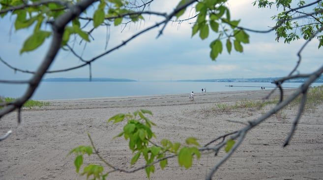
The vegetation at the Anse-Tibbits, in Lévis, gives the impression that the bank is natural, but it is not. (Sidney Meury)
Same thing for the little point that forms the Beauport bay beach: there is no apparent wall or backfill, which gives it natural tunes, but it is on no old card. Due to its size compared to the rest of the bay, it would have been impossible to ignore by any cartographer; It must therefore be concluded that it did not exist.
“In the historical photos, as we can see,” said Mr. Mériy. We have photos of 1948 where there is simply nothing there. And in photos taken 10 years later, we see the appearance of a large mound of sand coming from the dredging of the seaway. ”
Finally, note that the same principle prevails for the Jacques-Cartier beach, in Sainte-Foy, which would not exist if we had not removed large quantities of materials at the top of the cliff to pass the train.
In all, calculates Mr. Mériy, it is no less than 42 % of the banks of the St. Lawrence would be made of “non-cohesive embankment materials” of this kind.


