Weather: Very strong winds, gusts arriving at up to 130 km/h, risk areas
Article dated 12/20/2024
ore 22:28
by Mattia Gussoni Meteorologist
Weather warning: I'm on the way very strong winds about Italy with folate until 120-130 km/h.
Maximum attention already from the next ones due to the passage of the Solstice Storm.
HURRICANE GUSTS
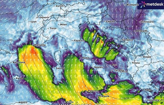
The clou phase worsening is expected in Friday 20th and Saturday 21st December: pay particular attention to the Sardinia where violent gusts of Mistral are expected up to 120-130 km/h. The Mistral will then affect a large part of the Centre-South.
We can scientifically talk about hurricane gusts when the wind reaches peaks equal to or greater than 119 km/h (Category 1 hurricane according to the classification scale of Saffir-Simpson).
Even the wave motion will consequently be very rough or even large, with the where which will be able to reach the relevant height of 6-7 meters: the risk of storm surges it will be concrete especially along the coasts of the two Major Islands and on the lower Tyrrhenian Sea.
The Bora and the Grecale will blow instead on the middle and upper Adriatic, here too with stormy gusts at over 90-100 km/h, especially on Romagna e Marche.
The Tramontana will sweep the coasts of Liguria causing a sharp drop in thermal values, while the Favonium (wind falling from the Alps) will break out on Piedmont e Lombardywith gusts of over 40 km/h even at Milano. Finally, it is worth mentioning twenty theses by Libeccio on the ionic sectors of Sicily, Calabria e Puglia.
FOR MORE INFORMATION: Weather: Solstice Storm, from Friday 20th Italy in the grip of a Cyclone, the details
Temperatures, consequently, are expected to drop significantly and we will feel even colder due to the so-called effect windchill: basically, when there is a lot of wind, the temperature perceived by our body is lower than the real one. The more wind there is, the more the temperature drops: generally, we are talking about around 3°C for every 10 km/h of wind speed.
And be careful because according to the latest updates, which have just arrived, also the Christmas week it will be stormy with the entry of new unstable fronts capable of causing not only precipitation, but once again also intense winds.
FOR MORE INFORMATION: Weather: Christmas week, the forecast has changed. Let's see what will happen for the start of the holidays


