
From reflection comes action. “Initially, we proposed a method to protect against flooding but also and above all to take advantage of the river,” explains Yannick Gourvil, partner of BMC2 Architectes, whose team (1) was the winner of the ideas competition at the end of 2021 Amiter (2). Their project, “Inhabiting the major bed of the Touques, a strategy of withdrawal and unfolding in the face of the concomitant risks of flooding” in the community of communes Cœur Côte Fleurie (CCCCF) [3]in Calvados, has since irrigated the considerations of elected officials and community services.
To the point that the latter has just awarded a contract worth around 700,000 euros for the creation of a guide plan for the development of the banks of the Touques, the specifications of which are imbued with the ideas which had been suggested in the competition . It indeed provides for a study at the scale of the main bed of the watercourse (4). This territorial unity, recommended by the winning team, was not until then envisaged by the project owners, as these seaside communities have turned their backs on their river for decades.
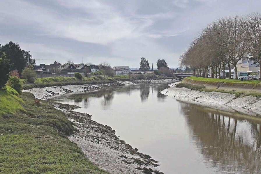
“Amiter only concerned two plots (34,190 m²) as well as the banks of the river in the town of Touques. We wanted to zoom out to the main bed [voir carte ci-contre]. Indeed, the risk of flooding – here by overflow, runoff and marine submersion – cannot be managed on a plot-by-plot basis.
Imagining the best building in the world will not solve the problems,” says the architect.
The multidisciplinary team, made up of architects, town planners and landscapers but also engineers, teacher-researchers and even a philosopher, also looked at the different temporalities of the developments. The reflection was projected over the long term with a “time 1”, where the rise in sea level remains less than 1 m, and a “time 2”, more distant, with a higher elevation which must already be integrated .
“A toolbox”. “The effects of climate change are such that they create a feeling of dizziness. They must be understood gradually via a flexible transformation process. Thus, we did not propose a project but a toolbox with several types of possible responses, in consultation with the population. This allows us to imagine a common future via a process capable of navigating uncertainty and adapting to it,” explains Yannick Gourvil.
To begin, the team recommended “tactical operations” developing uses with the river, for example the rehabilitation of a building, located on its banks, to make it a nautical base and the construction of an inn for seasonal workers. next to. The latter will be able to abandon its ground level at “time 2”, while providing access to the nautical base via a footbridge. At the same time, it was proposed to create a landscaped city entrance open to the Touques and to create structuring urban and landscape elements revealing flood phenomena and adapting to hazards: urban quay anticipating rising water levels, development of flood-prone banks, renaturation …
“For the longer term, we have imagined typologies of transitional buildings that can be dismantled, recyclable and do not include any housing in the thickness of the vulnerable zone. We also made several proposals on neighboring plots, even those not affected by the flood, in a spirit of territorial solidarity,” notes Yannick Gourvil. The ideas formulated in 2021 inspired the broad spatial and temporal framework retained for the specifications of the future guide plan. Its objective is in fact to “design, for the thirty years to come, the entrance and the heart of the CCCCF agglomeration in the short, medium and long term by proposing an innovative and sustainable vision of the territory and by repositioning the river in the heart of the city. Having just been selected for this mission, the TER agency (manager) and its team (5) will therefore work for twenty months on this territorial resilience plan.
(1) With Céline Bodart and Antoine Begel (Commune), Artelia, Atelier Florence Sylvos, Chris Younès.
(2) Launched in February 2021, it aimed to bring out innovative development projects to ensure change of nine territories throughout France. (3) The CCCCF, located between Cabourg and Honfleur, brings together 12 municipalities.
Its population is 20,778 inhabitants – and up to 120,000 in high season – on a territory of 11,817 hectares.
(4) Maximum bed occupied by a watercourse when water overflows out of the minor bed where it flows most often. (5) With BMC2 (Yannick Gourvil), Artelia, Cuesta, Atelier PréAU, Créaspace and Céline Coderch.
“The objective is to translate the guide plan into the PLUi”, interview with Caroline Vigneron, deputy general director of services and director of the territorial planning and prospective department of the CCCCF
How did the idea of participating in the Amiter competition come about?
The origin of this approach was the development of our territorial climate-air-energy plan (PCAET). We worked on the consequences of climate change with Cerema who told us about the Amiter competition organized by Puca. It seemed interesting to us to have architectural agencies work without it committing us, either financially or in launching projects.
We then proposed to open the discussion on land located on the banks of the Touques, very well placed but in the red zone of the PPRI, therefore subject to a significant flood risk.
How did the community move from this competition of ideas to the launch of a guide plan?
In 2022, students from the School of Architecture of the City & Territories Paris-Est proposed to the City of Touques to come and carry out a study on themes similar to that of Amiter. It focused on the three risks of flooding – overflow, runoff, marine submersion -, the requalification of the entrance to the city and the place of water in the landscape. Following their study and that of Amiter, the community decided to launch the production of a guide plan incorporating their recommendations.
When will the orientations of the guide plan be known?
We have just awarded the contract for the project management contract which marks the start of twenty months of studies. The objective is to gradually return the city to its river, with developments but also calls for projects from associations to liven up the banks.
It also involves reclassifying the activity zone dating from the 1970s, and providing avenues for building in a resilient manner, for example with buildings adapted to floods that follow the rhythm of the tides. An important consultation component is of course planned. The recommendations of the guide plan will allow us to translate it operationally into the PLUi via development and programming guidelines (OAP).