
For a long time, Hurricane Kirk was only known to weather enthusiasts. However, the tropical storm has now turned into an extratropical depression and is moving from Britain to the Baltic Sea. It brings strong winds and sometimes large amounts of precipitation to parts of Spain and France in particular, while Switzerland is only marginally affected.
Career of Kirk
At the end of September, a tropical depression formed west of Cape Verde. It is the eleventh named system – Kirk in the current Atlantic tropical storm season. As a result, Kirk continued to strengthen and reached hurricane status on October 1 (average winds of over 121 km/h). Until October 4, the hurricane continued on a northwesterly track with continuous strengthening, and its core pressure dropped to 934 hPa in the meantime. With mean winds of around 230 km/h and peak winds of up to 280 km/h, it reached category 4 (out of 5). As is often the case with such tropical systems, the track begins to turn more and more from northwest to northeast from around 25 degrees north latitude. This is due to the influence of the jet stream (strong wind band at a height of 8 to 12 kilometers, which blows from east to west), but also the Earth’s rotation (Coriolis force), which causes a deflection to the right (i.e. to the east in the northern hemisphere) with increasing latitude.
On October 7, Kirk was a category one hurricane to the southwest of the Azores over increasingly cooler waters. The tropical characteristics of the storm were subsequently lost due to a lack of energy supply from the sea surface. The now extratropical depression passed north of the Azores and headed for northern Spain and the west coast of France.
Fig. 1: Hurricane Kirk on October 4; Source: EOSDIS Worldview
Effects on Europe
In Europe, the Iberian Peninsula and France are most affected by the wind field. Winds of 80 to 100 km/h are expected near the coast, with gale-force gusts in slightly exposed locations. On the Mirador del Cable in the Spanish national park “Picos de Europa”, a gust of 205 km/h was measured this morning. On the Vega de Urriellu and on the Valdezcaray it was 145 km/h and 144 km/h respectively.
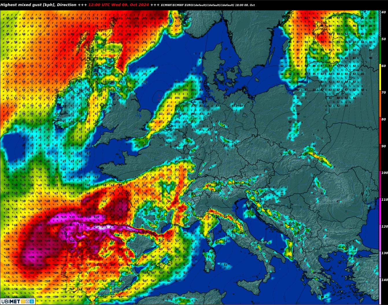
Fig. 2: Strongest wind peaks today at noon according to ECMWF; Source: MeteoNews/UBIMET
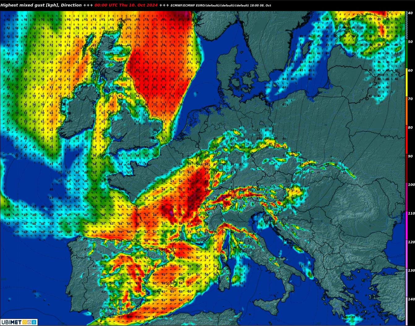
In the second half of the day, the low pressure system moves eastwards over France. In the Alps, the drop in pressure in the north results in strong to stormy southerly Foehn winds (see also corresponding wind warnings).
Fig. 3: Strongest wind peaks until midnight according to ECMWF; Source: MeteoNews/UBIMET
Outside the Alpine valleys, it becomes increasingly stormy in Switzerland towards the evening and especially on Thursday night. In the lowlands, wind speeds of 60 to 80 km/h are likely to be widespread, and even higher in slightly elevated or exposed areas. A storm with gale-force gusts in places is raging on the mountains. The following maps show the approximate wind peaks to be expected until tomorrow.
Large amounts of precipitation in some areas…
The cold front responsible for the strong winds also brings heavy precipitation in some areas. Outside Switzerland, the heaviest rainfall is expected in a band from Nantes via Paris to the Benelux countries and on to the Baltic Sea. In addition, the Pyrenees – are likely to see accumulated precipitation similar to that in the Alps –.
As the air masses are of subtropical originthe moisture content is above average. In this context, there is also talk of precipitable water. The potential for flooding is significantly increased in the areas mentioned above, and in some areas it is even pre-programmed. Click here for the rain warnings for France.
… And in Switzerland?
Once again, southern Switzerland in particular is hit hard. Depending on the model, 50 to 80 mm and local outliers are expected by Thursday evening in the worst-affected regions, with the majority falling during the night.
Fig. 7: Expected precipitation amounts until Thursday evening; Source: MeteoNews/UBIMET