A fairly clear change in weather is looming in France. While temperatures are currently wintry and often below average, the thermometer should quickly display early spring values, according to Météo France forecasts.
Maximum values should therefore increase by up to ten degrees between now and Friday in the northern part of France. The rise in temperatures has also started slightly since the weekend which has just passed. The forecasts for the national thermal indicator for the coming days also point in this direction. This indicator aggregates the readings from around thirty meteorological stations representative of the metropolitan area. While it has been between 0 and 2° in recent days, the different weather models, represented in this Infoclimat graph by various colors, anticipate a rise in the average temperature between 3°C and 7°C for the day. on Thursday.
This Monday afternoon, when temperatures will be the highest, they should generally peak between 0 and 5°C in the northern half, a little closer to the coast. They would oscillate around ten degrees in the southern half, possibly even approaching 15°C in the regions closest to the Pyrenees and the Mediterranean. In the latter, the levels should remain the same in the coming days.
This will not be the case in the northern half. On Tuesday, the maximum temperatures should gain between 2°C and 3°C compared to Monday. Wednesday and Thursday they would remain of the same order but would rise between 2°C and 3°C on Wednesday in the central regions, from Vendée to Lyonnais and in their surroundings.
Early April temperatures
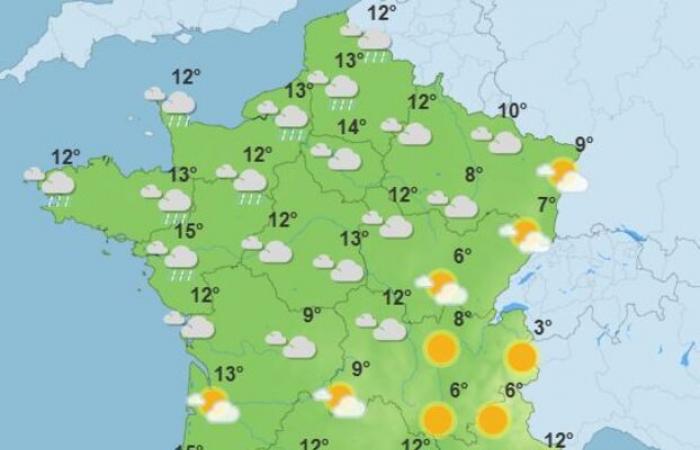
It's Friday that the difference will be noticeable. During the day, north of the Loire, the maximums will range from 7°C in the east of France to 14°C in the Pays de la Lorie. In the evening, as shown in the map below, 15°C could even be reached there. It would be at least a dozen degrees as far as the western part of the Grand Est region, between 13°C and 14°C in Hauts-de-France and Île-de-France. It will be warmer there than in the South.
-Saturday and Sunday, temperatures should be fairly uniform across the country, ranging from 12°C to 15°C in the plains. Only Corsica would stand out with around twenty degrees.
Such levels would be around 7°C to 8°C above seasonal temperatures in the north of the country. In the south of France, the difference would be contained at around 3°C. These would be values equivalent to the start of calendar spring, i.e. the period from the end of March to the beginning of April.
This rise in temperatures will go hand in hand with a significant rainy deterioration. If the North and the North-West should be among the wettest areas taking into account the whole week, as shown in the animation below, Wednesday and Thursday should be copiously rainy days overall. of the country or almost.
This situation should in no way prefigure the program for the following weeks. All weather models are converging towards a dry and warmer than average month of February. The snow would almost disappear below an altitude of 2000 m.


