The weather conditions are far from calming down this week. Cover up between this Wednesday and Thursday, the snow returns.
You are not likely to be spared from the cold again this week. The freezing rains this weekend and the Floriane depression have already set the tone for a recovery marked by agitation. These tumultuous weather conditions favored a conflict of air masses, characterized by a depression off the coast of the English Channel, this Tuesday.
At the end of the day, a mild spell is expected from the southwest with the arrival of active rains over 3/4 of the territory during the night from Tuesday to Wednesday. “North of the Seine, the cold air is still resisting with generally dry weather,” specifies La Chaîne Météo.
This Wednesday, rain will continue to fall over the majority of the country, accompanied by a noticeable wind coming from the southwest at 70 km/h in the northwest. But the situation is more particularly sensitive in the north of France. “In the far north, the flow will be from the northeast, since it is located in the upper part of the depression.
In this occlusion, it is the cold air which will rush into Hauts-de-France. In contact with the disturbance coming up from the south, snow could fall, in quantity, as far as the plains near Belgium, since temperatures would remain close to the 0°C mark”, according to forecasts from La Chaîne Météo.
The models are currently having difficulty reaching agreement and are proposing divergent scenarios. Indeed, the instability of the depression makes it difficult to make solid forecasts. It only takes a shift of a few kilometers for the situation to change.
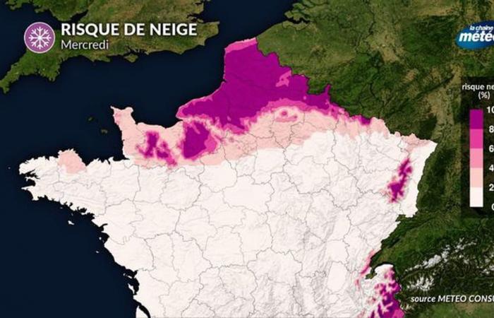
In the immediate future, the models are considering two possible scenarios regarding the risk of snow between Wednesday and Thursday morning. The first, the most probable, supports the arrival of a shower of flakes between Brittany and the Grand-Est, with the arrival of cold air from the northeast over part of the northern half. This snowy episode is illustrated on the map above, it would extend from the north of Paris to Belgium, but would intensify in Nord-Pas-de-Cas with colder, even negative temperatures.
“In this situation, the snow could stick to the ground and accumulate near Belgium,” underlines La Chaîne Météo. The departments affected by a probability of more than 80% of snowfall in the plains are: Nord, Pas-de-Calais, Somme, Seine-Maritime, Oise, Ardennes, Eure and part Calvados and Aisne.
The Weather Channel forecasts possible accumulations of “5 to 10 cm on the Picardy plateaus as far as Artois, by early Thursday morning”. “A significant risk of black ice is also present at the very beginning of this Thursday morning”, also writes the institute, which also fears up to 50-60 mm of rain in Morbihan and saturated soils and courses of rising water.
In the second scenario, less likely, the mild air prevailing up to the north of the capital would restrict the snow conflict to the northernmost part of the country. If you want to see the white gold fall for sure, it is recommended to go to Hauts-de-France where the snow will be there in part of the Nord and Pas de Calais.


