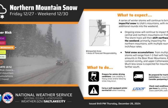
Park City snowpack levels dipped to less than 50% of average for December, reaching a 30-year record low this year. But several storms rolling through from Christmas Day through Monday should help jump start ski season here with an estimated accumulation of 22 to 30 inches.
OpenSnow forecaster Evan Thayer cautioned that warmer temperatures and wind may make the five-day buffeting better for building that skinny base than riding, but hey, it’s something.
Higher up the mountains, the total could reach up to 3 feet of fresh snow, according to the Salt Lake City National Weather Service.
“We have a prolonged period of storminess coming up here,” said Mike Wessler, meteorologist with the National Weather Service. “We are going to see moisture and wind. Most of that wind will be out of the west, with gusts along the ridgelines at potentially 50-60 mph. Hidden Peak and Baldy are seeing even higher speeds, plenty to move some snow around.”
The combination of historically low snowpack and the current onslaught, along with high winds, has put avalanche forecasters on edge. On Tuesday a snowmobiler in the Logan area was caught and buried by an avalanche, and that was before the first storm in this series made Christmas Day white. He was fully buried but recovered without injury after being quickly located and rescued by his brother using an avalanche transceiver, according to the Utah Avalanche Center.
Trent Meisenheimer, a forecaster with the Avalanche Center, explained in a video Wednesday that the snowpack is extremely unstable right now.
“It’s no doubt that Utah has hardly any snow. We have a very dangerous snowpack set up,” he said. “We’re doomed in Utah for a very dangerous winter. Our snowpack is completely faceted, and this is across the entire state. This snow is loose, it does not bond. As we stack snow on top of it with the storm this weekend, this weak snow will give way.”
As the snowfall continues, forecasters expect the avalanche risk to rise to high danger ratings.
“Heavy snowfall and drifting by strong winds will elevate backcountry avalanche danger over the next several days,” the avalanche center forecast on Friday morning. “Very dangerous conditions and HIGH avalanche danger are expected to develop in many areas.”
The center warned that new snow falling on top of these fragile layers will overload the weak pack beneath, increasing the risk of sliding. The weather will continue to fuel the dangerous conditions, with the storm expected to intensify through the weekend.
Meisenheimer said that northern Utah is going to become very dangerous as the storms progress.
“This is not the year to be riding in avalanche terrain, and what that means is any slope steeper than 30 degrees. We don’t want to be adjacent to, below, or on any terrain steeper than that,” said Meisenheimer. “It doesn’t matter if you’re sledding, snowboarding, throwing snowballs, northern Utah is going to be dangerous for some time to come.”


