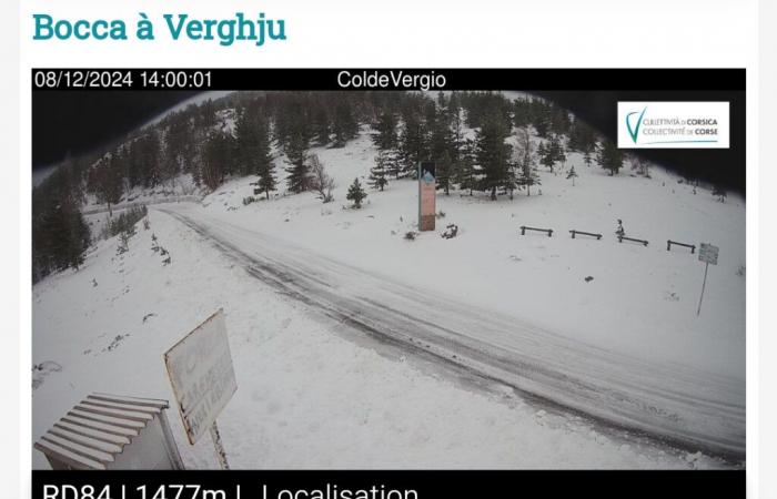
The first snow appeared very early this season, since Monte Ritondu was covered by a few millimeters last Friday September 13! Snow which returned in force and more consistently on November 21 with temperatures which had dropped sharply in Cortenais. But this time it is the Darragh storm which has been raging since yesterday Saturday through this cold drop which has also affected Corsica since last night.
It was in the second part of the night that the first flakes appeared in Vizzavona, but also at the Sevi pass, the Vergio pass, the Verde pass as well as on the Ghisoni and Ascu stations.
If in Vizzavona, the road was darkened very early this Sunday morning, on the other hand, special equipment remains mandatory to cross the other passes, while the circulation of articulated vehicles is prohibited there.
Elsewhere, special equipment is strongly recommended, especially as Météo France forecasters are announcing further snowfall tonight as well as tomorrow during the day, even if the expected quantities should remain low. However, according to those responsible for the CdC roads department, there was no particular problem crossing the Vizzavona pass.
This Sunday, Corsica is placed on yellow alert for snow, ice and avalanche phenomena until tomorrow. The maximum temperatures recorded this Sunday by Météo France were well below seasonal norms with 10° in Bastia and 7° in Corte. As for the temperatures felt, they were around 4° in Corte, for example, due to the sustained north wind. We also noted -1° at Vizzavona as well as -4° on the relief.
A few showers will still be possible this Monday throughout the day with a rain-snow limit located at 1,000 meters above sea level. Temperatures should be between 8° and 11° with only 14° in the Eastern Plain. Tuesday returns to calm, but the weather should remain overcast throughout the day
France


