Even though tropical models show Sara, once a powerful tropical storm, moving through Central Florida this week, the severe weather threat is extremely low.According to the National Hurricane Center, Sara has dissipated after moving through Mexico and will now continue moving into the Gulf of Mexico as remnants of a tropical system.As of 4 a.m., Sara had maximum sustained winds of 30 mph and a minimum central pressure of 1,005 mb. Any additional strengthening is not expected, and the NHC said it is no longer issuing advisories on this system. Even though Sara is not a powerful storm, the tropical moisture associated with the system must go somewhere. Models show that moisture combining with an oncoming cold front that will push into Florida around Wednesday.During that time, rain chances will increase significantly. Though the beginning of the week will remain pretty clear, the slow-moving front will bring widespread rain and possibly a few storms — starting in the morning and not clearing until the afternoon.After the front and Sara’s moisture moves through, drier air is on tap and so are cooler temperatures, even dropping into the 40s by this weekend.Where is Sara going?First Warning WeatherStay with WESH 2 online and on air for the most accurate Central Florida weather forecast.RadarSevere Weather AlertsDownload the WESH 2 News app to get the most up-to-date weather alerts.The First Warning Weather team includes First Warning Chief Meteorologist Tony Mainolfi, Eric Burris, Kellianne Klass, Marquise Meda and Cam Tran.
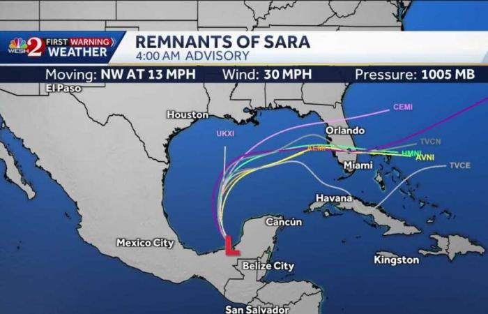
Even though tropical models show Sara, once a powerful tropical storm, moving through Central Florida this week, the severe weather threat is extremely low.
According to the National Hurricane Center, Sara has dissipated after moving through Mexico and will now continue moving into the Gulf of Mexico as remnants of a tropical system.
As of 4 a.m., Sara had maximum sustained winds of 30 mph and a minimum central pressure of 1,005 mb. Any additional strengthening is not expected, and the NHC said it is no longer issuing advisories on this system.
Even though Sara is not a powerful storm, the tropical moisture associated with the system must go somewhere. Models show that moisture combining with an oncoming cold front that will push into Florida around Wednesday.
During that time, rain chances will increase significantly. Though the beginning of the week will remain pretty clear, the slow-moving front will bring widespread rain and possibly a few storms — starting in the morning and not clearing until the afternoon.
After the front and Sara’s moisture moves through, drier air is on tap and so are cooler temperatures, even dropping into the 40s by this weekend.
Where is Sara going?
First Warning Weather
Stay with WESH 2 online and on air for the most accurate Central Florida weather forecast.
Download the WESH 2 News app to get the most up-to-date weather alerts.
The First Warning Weather team includes First Warning Chief Meteorologist Tony Mainolfi, Eric Burris, Kellianne Klass, Marquise Meda and Cam Tran.


