As an atmospheric river is expected to bring heavy rain and mountain snow to California, many are turning to Google to search the term “bomb cyclone.”But what is that? In short, it’s a rapidly intensifying storm system. The “bomb” term comes from “bombogenesis” which in the meteorology community is defined as, a storm system that experiences a drop in surface barometric pressure by 24 or more millibars in 24 hours. Around the immediate cyclone, winds can increase rapidly, and rain or snowfall rates can become intense. Bomb cyclones are most common in the winter season and occur more frequently off the Northeastern U.S. coast. However, they can form here on the West Coast. The last notable one we saw in Northern California was in 2021. Downtown Sacramento broke a 24-hour rainfall record when 5.44 inches fell on Oct. 25 of that year. This week’s storm system did officially achieve “bomb cyclone” status on Wednesday afternoon. The minimum central pressure dropped from 997 millibars at 4 p.m. Monday to 955 millibars at 10 a.m. Tuesday. However, the center of the storm will remain well offshore, keeping the strong wind threat away from Northern California. It will instead be the atmospheric river, the first one of the water year, making its way through the region. The KCRA 3 weather team is issuing an Alert Day on Wednesday because of the rainfall for areas near and north of Interstate 80. We are not expecting that amount of rainfall from the 2021 storm this week or any intense destructive winds. Get a look at the forecast for the week here.This storm and periods of rainfall from Nov. 20-23 will likely bring total rainfall around Sacramento to about 3 inches.See more coverage of top California stories here | Download our app | Subscribe to our morning newsletter
As an atmospheric river is expected to bring heavy rain and mountain snow to California, many are turning to Google to search the term “bomb cyclone.”
But what is that? In short, it’s a rapidly intensifying storm system.
The “bomb” term comes from “bombogenesis” which in the meteorology community is defined as, a storm system that experiences a drop in surface barometric pressure by 24 or more millibars in 24 hours.
Around the immediate cyclone, winds can increase rapidly, and rain or snowfall rates can become intense.
Bomb cyclones are most common in the winter season and occur more frequently off the Northeastern U.S. coast.
However, they can form here on the West Coast. The last notable one we saw in Northern California was in 2021. Downtown Sacramento broke a 24-hour rainfall record when 5.44 inches fell on Oct. 25 of that year.
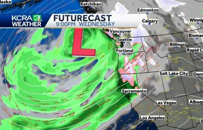
This week’s storm system did officially achieve “bomb cyclone” status on Wednesday afternoon. The minimum central pressure dropped from 997 millibars at 4 p.m. Monday to 955 millibars at 10 a.m. Tuesday.
However, the center of the storm will remain well offshore, keeping the strong wind threat away from Northern California.
It will instead be the atmospheric river, the first one of the water year, making its way through the region.
The KCRA 3 weather team is issuing an Alert Day on Wednesday because of the rainfall for areas near and north of Interstate 80. We are not expecting that amount of rainfall from the 2021 storm this week or any intense destructive winds.
Get a look at the forecast for the week here.
This storm and periods of rainfall from Nov. 20-23 will likely bring total rainfall around Sacramento to about 3 inches.
See more coverage of top California stories here | Download our app | Subscribe to our morning newsletter
Belgium


