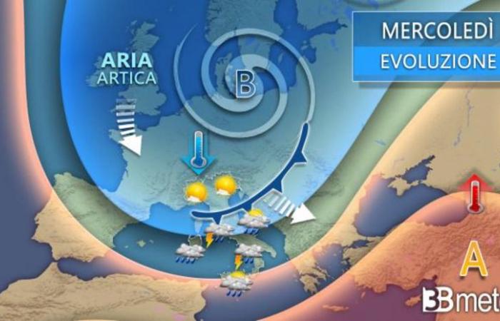
The first disturbance comes to Italy from Northern Europe. But new eddies will soon emerge from the nearby Atlantic and move towards Central Europe. The first is expected in Germany tomorrow, Tuesday, bringing with it an intense disturbance that will cross Italy on Wednesday. A second will arrive on Thursday and follow in the same direction. Two episodes of bad weather The first half of the week will therefore be characterized by heavy rainfall and strong, even stormy, winds, explains 3B Meteo. The The temperature will tend to rise in this first phase, both due to the southerly winds and the Föhn effect of the falling currents from the Alps and the Apennines, before starting to fall on Thursday with the arrival of the Arctic air.
On Tuesday rain in the Levante and snow in the Alps
North, generally cloudy skies over Liguria and the Po Valley with some rain in eastern Liguria. More clearing over the Alps and foothills of the Alps with snowfall in the western border areas of the Alps. Center, cloudy over the Tyrrhenian regions, in Umbria and the Marche with isolated rain between Tuscany and Lazio. More information about Abruzzo. South, some rain in western Sardinia, the Tyrrhenian regions and from the afternoon also on Sicily. More sunny stretches elsewhere. Temperatures continue to rise slightly, winds from moderate to strong from the southwest in the Tyrrhenian region, moderate from the south elsewhere. Seas very agitated, up to stormy the central and northern Tyrrhenian Sea.
Wednesday showers and thunderstorms in the center and south
North, rapid unstable passage between Friuli-Venezia Giulia, Emilia-Romagna and eastern Liguria with showers that quickly fade away. Sunny elsewhere, except snow in the border areas of the Alps. Center, unstable with showers and thunderstorms, locally intense over the Tyrrhenian strip, but weakening quickly from Tuscany in the afternoon. South, unstable between Campania and Calabria with showers and local thunderstorms, some rain also in Sardinia and Sicily, irregularly cloudy elsewhere without significant phenomena. Temperatures continue to rise in the south and along the Adriatic. Strong winds from the west or southwest.
Thursday Rain at the end of the day in the northwest. Temperatures are falling
North, initially sunny, then increasing clouds from the west with widespread rain by the end of the day in the northwest and weaker in the northeast. Snow falls into hilly areas. Center, worsening from the west with widespread rain and showers until the afternoon over the Tyrrhenian regions and also in the Adriatic until the evening. South, unstable in Sardinia, worsening by the afternoon also over the Tyrrhenian regions with showers in Campania and by the evening in Calabria and Sicily. Better on the Adriatic. Temperatures will fall in the north and in the center until the evening, stable or continue to rise in the south. Strong winds rotating from northwest quadrants. Seas very choppy or stormy.
Arctic air from Friday

How 3B Meteo explained, the entry of cold air of arctic origin over Italy will occur on Thursday and will spread over much of the peninsula until Friday and the first half of the weekend, followed by a rapid disturbance accompanied by stormy winds. Therefore, a partly disrupted Friday with rain, thunderstorms and also snow, which could fall into hilly areas in some areas due to the drop in temperature. In the second half of the weekend, the development of a deep low pressure area over the Atlantic in Western Europe and also over Italy will trigger an influx of moist and mild air of North African origin, which will end the cold phase. The change is expected with a final disturbance expected to arrive on Sunday, but for now it appears to only affect northern regions.
The cold front on Friday
The passage of the cold front, which will bring showers and thunderstorms in the center and south, with snow reaching medium and low altitudes in the Apennines of Emilia, Tuscany, Marche, Lazio, Abruzzo and, towards the evening, even below 1000 m also in the south, between Campania, Molise, Apulia and Basilicata, can sink. Wide clearings will affect the north. Temperatures are clearly falling. Strong winds rotating from northern quadrants with stormy seas and storm surges along exposed coasts.
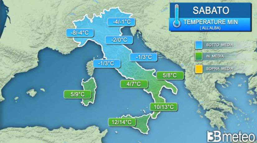
What changes on Saturday
An overall sunny day in Italy, but still cold in the morning, especially in the north and along the Adriatic. Winds will shift from the southern quadrants.
The forecasts for Sunday
New unstable/disturbed transit expected in the north in a generally milder climate for all. Strong southerly winds.
© ALL RIGHTS RESERVED
This article is automatically translated


