After the passage of a vigorous cold front this Tuesday, accompanied by driving rain and sustained wind, a rapid drop in temperatures will take place during the night from Tuesday to Wednesday, in the regions located north of the Loire. On Wednesday, this cold air will have invaded the northern two-thirds of the country.
Sudden cooling during the night from Tuesday to Wednesday
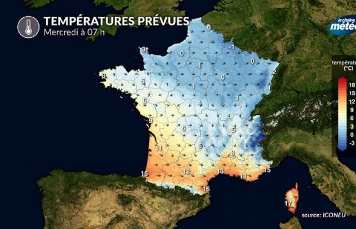
Temperatures begin to drop Tuesday evening in the north © The Weather Channel
It is Tuesday evening and during the night that the wind will turn to the north after the rains of the day. The feeling will become very chilly, especially as the wind will still be sensitive. But the precipitation will stop and it will not snow in these regions located north of the Loire.
On the other hand, on Wednesday morning, temperatures could approach 0°C in the Hauts-de-France and Ile-de-France countryside, which could cause the formation of a few patches of ice. This phenomenon will be limited but be vigilant, especially on two-wheelers.
Cold air will have invaded the northern half Wednesday morning © The Weather Channel
A Wednesday as cold as December
We will really notice the cooling on Wednesday during the day. Certainly, clearings will return to the northern half of the country, with blue skies. But the light wind will be really cool, and maximum temperatures will not exceed 4 to 6°C in the northeast, and barely 8 to 10°C in the northwest. This is certainly not remarkable, but on the one hand, we are not used to it and it will objectively be temperatures 3 to 5°C lower than the seasonal averages, worthy of a December normal.
Thursday, another cold day with snow on the plains
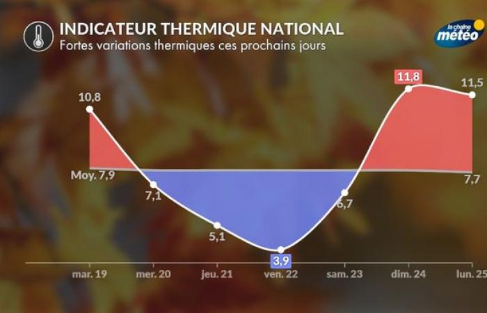
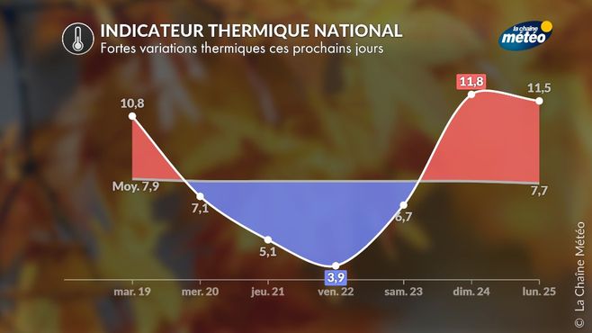
Thursday will be an equally cold day, excluding the regions located south of the Garonne as well as the surroundings of the Mediterranean, which will be very windy. But elsewhere, it will be just as cold with a episode of snow in the plains. However, except in the mountains, the frosts will remain quite weak, so that the snow on the plains will really struggle to hold on. On the other hand, the first reliefs in the center-east could experience a fairly significant snow episode from Thursday until Friday morning. Maximum temperatures on Thursday will remain between 3 and 6°C over the northeast two-thirds, and locally close to 0°C under the Burgundy snow.
Friday, last day of cold
The evolution of snow in the center-east and south-east remains to be refined. On the other hand, the cold seems well established, of the same order as the day before, with morning frosts in the east, where the night sky will have cleared, particularly on snowy ground. it will be the coldest day nationwide as nighttime lows will be lower. For the future, a significant mild spell will set in on Saturday across the country.
© The Weather Channel

