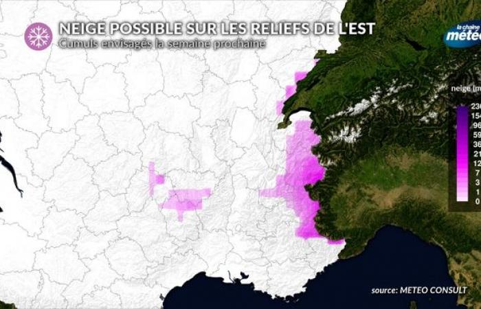
Even if the current situation is not unprecedented, the snow deficit is still remarkable in our mountains. After the two bouts of snow in September and October, an anticyclonic situation emerged, synonymous with dry and mild weather at altitude. However, this situation should change next week with the probable passage of a cold drop over the countries of Central Europe. Under its influence, fairly cold air should reach eastern France, bringing some snowfall at medium altitude. Please note that the evolution of this situation is not yet reliable and that many uncertainties persist.
A new cold drop on Central Europe
A cold drop will form next week over Central Europe © The Weather Channel
Cold drops punctuated our European autumn. We remember that of mid-September which caused historic floods in Poland and Austria, bringing huge depths of early snow to the Alps. Since then, snow has remained very rare. In addition, an unusual mildness has reigned since October 13, which contributed to the melting of this first white coat of which there is nothing left below 2600 to 2700 meters altitudewhether for the Alps or the Pyrenees.
But the weather will change next week. Our anticyclone will retreat towards the British Isles, letting fairly cold air infiltrate central Europe, forming a depression, synonymous with unstable weather (rain and snow in the mountains). This “cold drop“, however, presents an unreliable development. According to weather models, its trajectory presents numerous divergences. It should concern the east of our country, before fading for the following weekend.
Cold weather, snow in the mountains: what to expect in our country?
Possible snow depths next week in the mountains © The Weather Channel
This cold drop will therefore lead to a drop in temperatures. This drop will be moderate, and we will roughly reach the seasonal averages, possibly 1 to 3°C below for 2 to 3 days. This change of atmosphere will be quite radical in the regions of the southern half, where the weather is currently spring-like. The mountain will experience the most drastic variation as cold air will circulate aloft.
As the cold drop passes, a disturbance will arrive from Germany to the eastern half of our country from Tuesday to Thursday. This disturbance will bring rain to the plains and very probably snow from 1100 m of the Vosges in the center-east, and from 1300 to 1500 m when arriving in the Pyrenees. The uncertainties concern the quantities of precipitation (rain and snow) which will fall as this disturbance passes. From the Jura to the Northern Alps and the northern slopes of Auvergne, 10 to 20 cm of fresh snow could fall at 1500 m altitude. However, this bout of snow will be brief because a mild spell and the return of dry weather already seem to be on the horizon for the weekend of November 16.
On this subject, our 4-week weather trend is not very optimistic about the chances of snow in the coming weeks.


